Walking the South West Coast Path: An In-Depth Guide
Articles on this site contain affiliate links, meaning I may be compensated if you buy a product or service after clicking them. The full privacy & disclosure policy is here.A few months ago, I turned 50.
It’s a bit of a tradition of mine to do a multi-day walk each year, and since the UK is my favourite place in the world to walk and I’d be there for my birthday anyway, it wasn’t long before a plan started coming together.
I’d walked the Cotswold Way, Hadrian’s Wall, South Downs Way, and Norfolk Coast Path in the past, and while they were all fantastic in their own ways, I found myself wanting to tackle something more than a week-long trail this time around.
I wanted a bigger challenge to celebrate another decade around the sun, and by God I got one.
On paper, the South West Coast Path looked like it would be the longest, steepest, hardest walk I’d ever attempted, and since I’d be sleeping in a tent most nights, I’d also be carrying more gear than usual. On more than one occasion before setting out, I wondered if I’d even be able to get to the end.
Seven weeks later, I had my answer. Through sun and rain, wind and…more wind, one foot in front of the other over one and a half million times, I’d made it. It had been even longer and significantly harder than I’d expected. It had also been the best thing I’d ever done.
I’ve spent the last few months writing up guides to each day of the walk, and I’m now finishing with this overall picture of what it’s actually like to tackle a long-distance trail like this, and what you need to know if you’re thinking about doing the same thing yourself.
The first part is all the logistical stuff: where it is, how to get there, accommodation details, distances, costs, what the food and drink options are like, and all the rest. The second part has overviews of the distance and difficulty you’ll encounter, with links to read (much) more about each day.
It’s the kind of guide I wish I’d had before I set out, and I hope you find it useful!
Planning and Logistics
Where Does It Start and Finish?

The South West Coast Path starts beside a large metal sculpture on the promenade in Minehead, a historic port town in West Somerset. From there it heads west into Devon and along the edge of Exmoor National Park, before turning largely south for the next 200 miles.
The path crosses into Cornwall at Marsland Mouth, between Hartland Quay and Morwenstow, and runs along the entire Cornish coastline. At Land’s End it turns east and continues through the rest of the county, before crossing back into Devon at Cremyll and finally heading into Dorset just before Lyme Regis.
The path finishes beside a smaller metal sculpture at South Haven Point, at the end of Knoll Beach and just across the harbour from Poole.
As I mentioned earlier, as well as this post you’re reading, I’ve written up individual guides for each day that I walked and put them on a map. Yes, all 49 of them! The map gives a good idea of where the path goes, so I’m including it below.
In terms of which way to walk, the trail is waymarked in both directions, but most people choose to start at Minehead and walk anti-clockwise with the sea on their right. That’s the direction I chose, but there’s no particular reason you have to. I met a few people going the other way, both those walking the entire path in one go and those doing it a few days at a time.
Just be aware that with the prevailing wind coming from the southwest, chances are you’ll spend more time walking into it if you start at South Haven Point.
How Long Is It?

Officially, the South West Coast Path runs for 630 miles (1014km). More than another other trail I’ve tackled, though, that number is at best a very rough guide to the distance you’ll actually walk.
Erosion is a major issue along the entire path, although some parts like the Jurassic Coast are more affected by it than others. As a result, temporary diversions and permanent rerouting are very common: barely a day goes by without encountering at least a minor change to the trail. These usually don’t add much extra distance, but there are exceptions, and it all adds up.
That’s before you factor in everything from walking to and from your accommodation, going off-trail to find food or supplies, optional detours to points of interest, and anything else you might do over the course of several weeks of walking.
Measuring from when I set out in the morning to when I arrived at my accommodation each night, my Garmin measured a total of 742 miles (1194km). If you include the walk to dinner and anything else I did in the evening, adding 20% to the official distance is probably a pretty good estimate.
Staying in campsites like I did added to the total: while some of the places I stayed were right beside the path, others were more than a mile from it. Opting for traditional accommodation (or wild camping) would have meant less walking overall.
How Hard Is It?

I’m not going to sugar coat it: walking the entire South West Coast Path in one go is hard work. It’s by far the most difficult long-distance path I’ve ever tackled, and despite everything I read beforehand telling me not to underestimate it, I still did.
That’s not just because of the distance, although obviously that’s part of it. 630 miles is the furthest I’ve ever walked in one go, a solid 140 miles longer than the Camino Frances, and that’s before you add the extra 100+ off-trail miles I mentioned earlier.
Much more than the distance, though, is the elevation change. I’d seen a few stats about the path before I started, and the one that stood out was that despite never getting more than 1044 feet (318m) above sea level, you climb and descend the equivalent of 4x the height of Mount Everest over the course of the walk.
At the time, I didn’t really have a grasp for exactly what that meant in terms of difficulty. Now, I do.
Over the entire 49 days, there’s five or six I’d classify as relatively flat. The rest have somewhere between a moderate amount of up and down, and a hell of a lot.
To make it harder, that elevation change often comes both quickly and repeatedly, especially in the early and late stages of the route. The section between Hartland Quay and Bude, for instance, has ten steep valley descents and climbs in the space of eight miles: it’s generally seen as the hardest day on the Coast Path, but there are several others that aren’t much easier.
Like the other National Trails I’ve walked in the UK, there’s thankfully very little walking on asphalt or concrete. That doesn’t mean that there aren’t hard surfaces, though: the path is often quite rocky, either large stones embedded in the dirt or just walking along a rocky cliff.
The steep, rocky descents combined with longer distances and hot temperatures during the early stages of my walk meant I ended up with a badly blistered and bruised toe within the first week. I hardly ever get foot injuries when doing a walk like this, but this one was a doozy. Let’s just say it didn’t make things easier!
While I got noticeably fitter and stronger over the course of the walk, I also got more fatigued. Towards the end, while I didn’t find the ups and downs as brutal as I did at the beginning, I was no less exhausted when I fell into bed each night.
All of the above, plus the difficulty of getting 6-8 weeks off to go on a very long walk, explains why most people don’t attempt the entire South West Coast Path in one go. Instead, they do it in sections, often a few days or a week at a time, over the course of a few years.
That doesn’t make the individual days any easier, of course, but it does reduce the overall exhaustion and risk of injury. That injury risk isn’t just theoretical: my shared walk with Lauren became a solo endeavour three weeks in, when she picked up when turned out to be a stress fracture in her heel.
Not that she realised that until she’d walked on it for another 50 miles, mind you!
All of that said, though, it’s not like every day is extremely strenuous. Just most of them 🙄. If you’re just wanting a nice walk along the coast and a bit of a taste of what the SWCP is like, there are several parts that are comparatively flatter and easier than the rest, or where you can just walk for a couple of hours between villages and then return via bus or taxi to where you started.
I’ve included a difficulty rating with each of my daily guides below, as well as the distance and elevation so you have some idea of what you’re in for if you walk the whole section. Click through on any of them to see a map and elevation profile: sometimes the tough stuff is all at the start or end, so you could choose to walk just part of the way and have a much easier time of it!
How Scenic Is It?

I’d usually find it hard to generalise about the beauty of 700+ miles of coastline, but not here. With remarkably few exceptions, the South West Coast Path is an incredibly scenic walk.
Before I set out, I was a bit concerned that the whole thing would end up feeling a bit samey by the end. I mean, walking with the sea on the right for the better part of two months around a relatively small corner of the country: wouldn’t I get bored of the view?
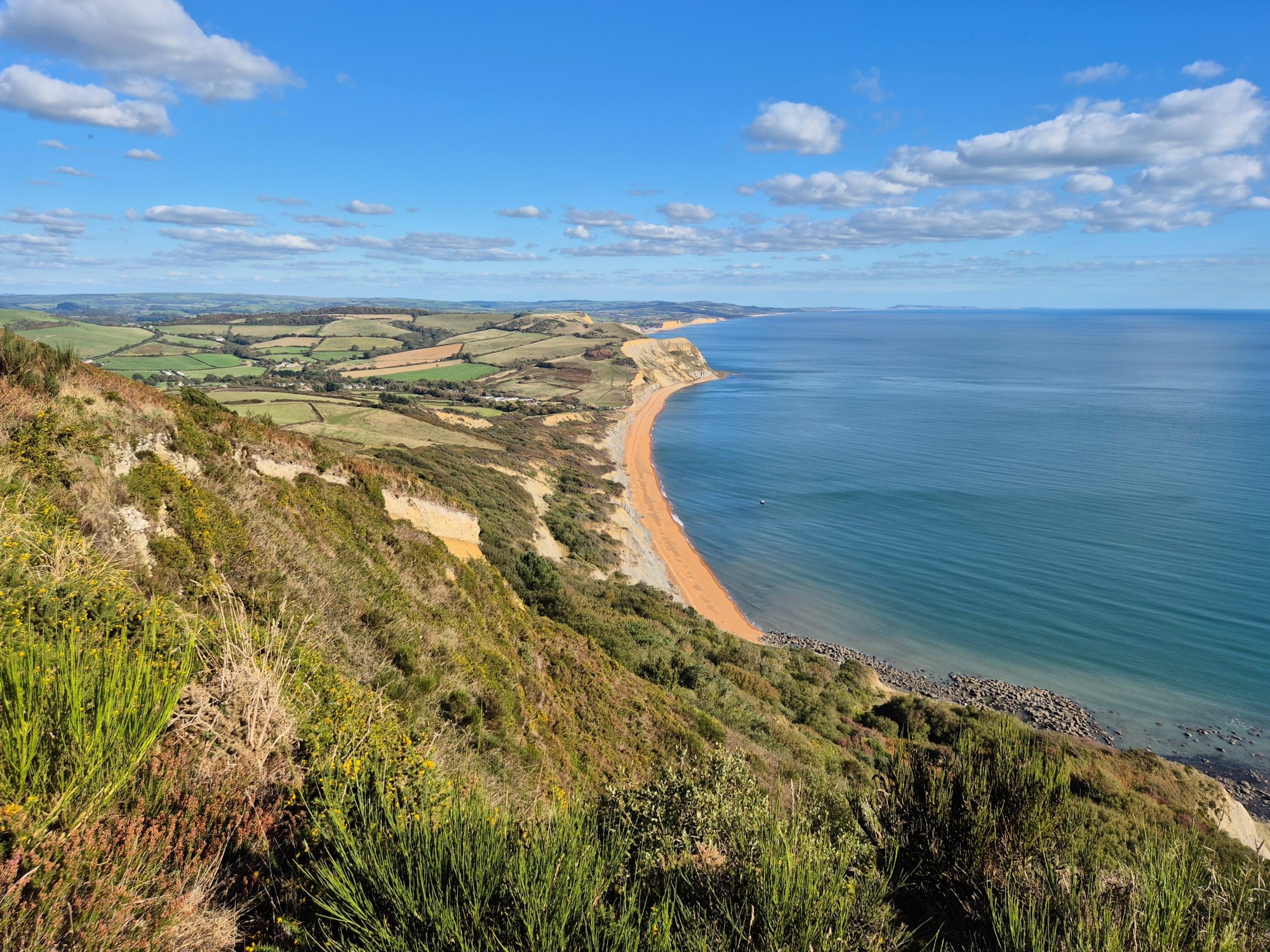
The answer was a definitive no. The path and the views change, if not hour by hour, then at least day by day and certainly week by week. Beaches change from wide sandy bays to pebbly beaches and rocky coves, and from gold to white to grey to orange depending on what they’re made from.
The ocean, too, endlessly changes colour, from glistening turquoise to dark blue and every shade in between. The windswept moorlands of Exmoor are nothing like the crumbling red cliffs of the Jurassic Coast, which likewise bear no resemblance to the surf coast of north Cornwall or the dark woodland of the Undercliffs near Lyme Regis.
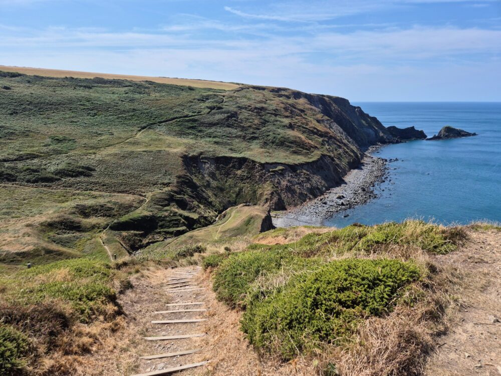
Many parts of the path are rugged and wild, especially when the wind is blowing and the waves are crashing below (or in some cases, over) the trail. It’s not all like that, though: there’s plenty of calm, peaceful countryside, dappled woodland paths, and gorgeous little villages as well.
Almost every time I found myself at the top of yet another steep cliff, gasping for breath and leaning on my hiking poles for support, there was an impressive view that made the climb worthwhile. Even if it didn’t feel like it right at that exact moment.
Really the only parts of the walk I didn’t love were through the cities, although even those had their merits. While the eastern side of Plymouth is industrial and ugly, for example, the western side is all charming Victorian buildings and historic harbours. Newquay’s high street around the train station isn’t particularly thrilling, but the dramatic surf at Fistral Beach on the other side of town is a whole other story.
What’s the History of It?
The South West Coast Path started off as a number of different walking paths used by coastguards and tax officers on the lookout for smugglers. That’s why it runs so close to the coast, with views from the cliff edges down into the innumerable bays and coves along the way.
The paths were still used for that purpose up until the early 1900s, at which point they started to transition from official to recreational use. Work started to join and upgrade the path in the 1970s, and it was opened in sections from 1973 to 1978, when it was designated as a National Trail.
The total length has changed over time since then, as sections get added, removed, and rerouted. The current 630 mile route (which is still very much an approximation) didn’t come about until 2003, when the circuit around the Isle of Portland in the final week was added into the mix.
How Popular Is It?

As I mentioned earlier, because it’s so long and hard, relatively few people tackle the South West Coast Path as a thru-hike. I met two others the entire time: part of that is probably due to starting a bit later than most others, but even so, only a tiny fraction of the people on the path at any given point are walking end-to-end in one go.
That said, nine million people or more walk some part of the route every year, and the vast majority of those are concentrated over the warmer months (roughly April through September). Certain sections end up very popular as a result, generally the shorter, easier, and/or prettier ones between one village and the next, especially in areas that are already popular with visitors.
Even so, with 630 miles of trail to choose from, there are vast empty spaces where it’s easy to go an hour or two without seeing another person. Even when I did come across a busy section, it was almost always near a village or town: a mile further down the path, there’d be nobody in sight once again.
This is not the Camino Frances: you’re not going to run into dozens of other long-distance walkers each day, make a “South West Coast Path family”, and walk the next several weeks with them. I didn’t walk with anyone who I didn’t already know for more than a few minutes until the final week.
If you like quiet, empty, beautiful trails and long periods of solitude, this is the path for you.
How Well Is It Waymarked?

Given how long the path is, and how much it changes year by year and even week by week thanks to erosion and other damage, I found the waymarking to be really pretty good most of the time.
That’s undoubtedly helped by an influx of money from the creation of the King Charles III England Coast Path, which officially opened this year and incorporates the South West Coat Path into its 2700 mile length.
Parts of the SWCP have been rerouted as part of this project, and as a result, many signs have been added or replaced. They now often just refer to “Coast Path”: with a couple of exceptions at Barnstaple and the Plym estuary, the SWCP and the KCIII ECP (great acronym) follow the same route.
The waymarks themselves take all kinds of different forms, although you can usually expect the National Trail acorn to feature on them somewhere. As well as wooden signposts with destinations and distances, there are simple black and white acorn stickers, metal signs, and wooden poles with directional arrows.
You’ll also find metal markers inlaid into footpaths, stones on the side of the trail, and even a huge rock with the acorn symbol carved into it sitting high on a hillside above Mount Batten, just outside Plymouth. If you manage to miss that one, you’re really doing well.
That said, as good as the waymarking generally is, it’s not perfect. There were plenty of places where there wasn’t a sign somewhere that probably should have had it: unclear trail intersections, for instance, or the beginning or end of a recent detour.
As usual with any long-distance walk, cities were generally the hardest part to navigate: that’s partially because they didn’t always have a sign or marker where they should have, and partially because there are just exponentially more options for which way to go!
Where there is waymarking, it’s done in both directions: as I mentioned above, while most people walk the path anti-clockwise, there’s no inherent need to do so, and you won’t be disadvantaged in terms of navigation if you do.
Whether you’re walking just a section, a week, or the entire thing, I’d highly recommend having some kind of map with you. Some people swear by paper maps: I understand their reasons, but at least for a path like this, I’m not one of those people.
Using a phone app means I don’t need to carry any additional weight, and I can see at a glance where I am versus where I’m meant to be. I have a phone case to protect against breakage and a lightweight power bank to deal with running out of battery, and for me, that’s mitigation enough.
I talk more about the app I used in a section below.
How Long Does It Take to Walk?

Simply because of its length and difficulty, different people take vastly different amounts of time to walk the South West Coast Path.
It took me exactly seven weeks (49 days) of walking to complete the path, plus three rest days where I tried to do anything except walk. That works out to be just over 15 miles (24km) each walking day, although of course the average hides a lot of variation: my shortest day was 8.3 miles (13.4km) right at the start, my longest was exactly 20 miles (32.2km) one day from the end.
The official guidebook breaks the trail up into 52 daily sections, and when I first looked at the distances, I naively assumed I’d be able to walk the path much faster. Remember that whole underestimation thing I mentioned earlier? Yeah, that.
All that elevation change really was no joke, especially in the earlier stages of the walk when I hadn’t yet built up the strength and fitness I’d have towards the end.
Camping and not booking ahead meant that I could adjust the daily distances to a certain degree, although I often still found myself walking further than I’d have liked to just to get to the next campsite.
If you’re staying in hotels, pubs, and B&Bs, or otherwise need to book your accommodation for whatever reason, I’d definitely recommend shorter distances than you think you can manage, at least until you get a good idea for what the SWCP is like and how much you can handle in a given day.
Wild camping gives the ultimate flexibility, of course, but comes with other issues: more on that in the accommodation section below.
Getting To, From, and Around the South West Coast Path
The Cornish peninsula is renowned for many things, but a good public transport network isn’t one of them. The beginning and end are relatively easy to get to, and the larger towns and cities also have decent train service to elsewhere in the country, but that’s about where the good bits end.
For much of the path, you’re looking at a patchwork of bus routes run by different operators, often with limited or no service at weekends. That’s assuming there’s a bus route at all: several sections aren’t covered by public transport, certainly not along their length and sometimes not between the start and end either.
In my daily guides, I’ve given as much information as I can about buses and trains each day where they exist, as well as parking details if you’ve got a car and want to leave it somewhere and walk to or from it.
For now, though, I’ll cover off getting to/from the beginning and end points, and point out several other places along the route that are at least relatively easily accessible from elsewhere.
Minehead

Minehead is one of those places where train service has actually got worse since Victorian times. Back then, with sea bathing and tourism in general on the rise, you could take a train from London and elsewhere all the way there. Now, while the rails still exist, they’re only used as part of a heritage railway that doesn’t run often or cheaply enough to be useful for walkers.
Even so, it’s not especially difficult to get to Minehead: chances are you’ll just have to swap to a bus somewhere, most likely Taunton. Services run at least once an hour from both Birmingham and London Paddington to Taunton, where you can swap to the 28a bus that drops you off on the Minehead esplanade, a few minute’s walk from the start point.
If you’re coming from further afield, the closest airports are Bristol and Exeter. In either case you’d need to take a bus from the airport into the city, and then catch a train to Taunton and bus to Minehead as above.
South Haven Point

The end at South Haven Point is almost directly alongside the vehicle and passenger chain ferry that runs across the narrow stretch of water to Sandbanks, on the outskirts of Poole. Foot passengers travel free on the ferry in this direction (it’s £1 going the other way).
More usefully for most, the number 50 bus that runs between Swanage and central Bournemouth also uses this ferry, and there’s a stop for it a short distance back down the road from the sculpture at the end of the path.
From both Poole and Bournemouth, trains and National Express coaches run regularly to London, Birmingham, and elsewhere.
Bournemouth and Southampton both have small airports, if you happen to need to go to one of the relatively few destinations they serve, otherwise you’ll likely end up flying out of London.
Other Useful Places to Get On and Off the Trail
The easiest places to get on or off the South West Coast Path are, unsurprisingly, those with a train station on the national rail network. There are a few others with heritage railways, both steam and electric, but they aren’t particularly useful for connecting to anywhere else.
Anti-clockwise from Minehead, these towns and cities are:
- Barnstaple
- Newquay
- Hayle
- St Ives
- Penzance
- Falmouth
- Par
- Looe
- Plymouth
- Paignton
- Torquay
- Dawlish
- Exmouth
- Weymouth
Other than Plymouth which is slightly further, the stations are never more than half a mile from the Coast Path.
Some, like Hayle and St Ives, are on a branch line where you’ll likely need to change at a larger station for onward travel, but it’s not a difficult process. Well, unless you’re like Lauren and trying to do it on a broken heel, but lets hope that’s not the case for you!
Weather

When the prevailing wind in the UK comes from the southwest, and you’re on the literal South West Coast Path, it’s perhaps no surprise that the area gets a bit of weather. I’ve done enough long-distance walking in this country to know that conditions can be gloriously unpredictable anywhere at any time, but they were still a lot on this walk.
Summer had been long, hot, and dry in the UK this year, and for the first three weeks of my walk, that pattern very much continued. We got hardly any rain at all during that time, especially during the day. Occasionally it’d rain overnight or in the early morning, but even then, it’d almost always clear to become warm (or hot) and sunny by lunchtime.
Even the wind, so much of a factor for the rest of the walk, was less of an issue during this halcyon three-week period. Much of the time it was more of a cooling breeze than anything else, although it did get noticeably stronger on some days.
The weather turned while I taking a rest day in St Ives: I bid farewell to Lauren in the rain, and things became much more autumnal from that point forward. I had much stronger winds, frequent heavy rain, and cooler temperatures for most of the next three weeks, with 60+ mph winds on a couple of days around Plymouth making things particularly interesting.
Just when I thought that was my lot, the weather changed again for my final week: minimal rain, cold nights, relatively little wind, and plenty of sunshine almost every day. What a relief that was!
The wind is stronger and more frequent here than pretty much anywhere else in the country, and it will almost certain affect your walk even if you don’t get the wind warnings and storms that I did.
There were a few times on narrow paths up on the cliffs or rounding a headland that felt dangerous because of it, and that’s before we even talk about the day my walking companion and I were thrown to our knees and kept there for the better part of a minute by a particularly strong gust!
On the upside, the persistent breeze/gale means that rain often doesn’t last very long: I’d often see clouds blow in off the ocean, dump their contents on my head for five minutes, and then disappear inland to leave dry, sunny weather in their wake. For half an hour, at least.
Assuming you’re not in the middle of a storm, it’s often also a bit warmer and drier on the coast than even a fairly short distance inland. Because the ground pretty much always rises as it heads away from the coast, the humid air that blows in off the Atlantic gets forced upwards and then falls as rain on the higher ground.
God knows that doesn’t mean you won’t get wet on the Coast Path: it just means you’d probably be even wetter if you were a few miles inland!
Accommodation

Because so much of it is through popular tourist areas, there was more flexibility with accommodation on the South West Coast Path than any of the other National Trails I’ve walked in England.
Campsites
That flexibility was helped significantly by choosing to camp most of the time: 40 of my 51 nights were spent under canvas. I’d expected to wild camp for some of those nights, but in the end I was able to find an established campsite every time I needed one, even if it required a bit more walking to get there.
One of the key things I learned is that even in the height of summer, there’s very rarely any need to book ahead for a tent pitch. The people who run campsites anywhere near the SWCP are very used to walkers wandering in late in the afternoon looking for somewhere to stay, and they’ll generally do whatever they can to find you a patch of grass for the night.
I booked ahead for our first two nights on the path, and didn’t do so again the entire rest of the way. That’s despite walking for much of the summer school holidays, including the August bank holiday weekend, through some very popular tourist spots.
If you’re going to have any issues, it’s more likely that it’ll be at the start or end of the season. I found myself having to call ahead more often towards the end of my walk, just to confirm that campsites were still open.
Some close as soon as the summer holidays are done, others sometime in September, and many from early October onward. You still don’t need to book, as such, but you probably do need to make the phone call if you don’t want to risk standing outside a locked gate at the end of a long day.
The other good thing about not booking ahead, especially for the larger/more corporate campsites and (especially) holiday parks, is that it’s often cheaper. Many campsites along the path have special rates for those who walk in with a small tent, but only if you just show up and try your luck, not if you book ahead.
Let’s take Durdle Door Holiday Park as an example: walking in, it cost me £20 for the night. If I’d booked ahead, the exact same bit of grass would have cost £43.
Wild Camping
If you decide to wild camp, all of those concerns disappear: you don’t need to worry about how much it costs or whether the campsite is open, closed, or full, and you can to some degree decide exactly how far you feel like walking each day.
There are other issues, of course. The first is that wild camping without permission is technically illegal, and viewed as civil trespass. If you’re asked to leave by the landowner and don’t do so immediately, it becomes a police matter.
Many people do it anyway (I met some and saw several others), and as long as you’re respectful and sensible about where you camp, set up at nightfall and depart first thing in the morning, and don’t leave any sign you were there, most landowners are unlikely to care. That’s not the same thing as having permission, of course, but chances are you’ll be fine.
Another issue is that if you don’t have experience wild camping already, finding appropriate spots can be difficult and stressful, especially in bad weather and/or as night is falling. I didn’t do it, so I’m not going to comment about how hard or easy it is, but it’s definitely possible: one person I know has walked the entire path several times, often wild camping the whole way.
Finally, you’ll obviously need to be pretty self-sufficient on the nights you’re wild camping. Chances are there won’t be a safe water source nearby, there almost certainly won’t be a toilet, and you’ll have to decide what to do about food, whether that’s preparing your own or eating somewhere in the evening before finding a place to camp.
None of that is insurmountable or even particularly difficult, but it’s still something else to deal with at the end of a long, hard day.
Hotels, B&Bs, Pubs, etc
If you don’t want to carry a tent and other camping gear, or just prefer your walls a little more solid and your bed a little more comfortable, there’s no shortage of other accommodation options.
That said, while that comment is generally true most of the time, it has to come with some caveats. In popular areas at popular times, you may well find a shortage of available accommodation, especially if you care about minor details like being able to afford it.
On the flip side, there are a few remote sections of the path where accommodation of any sort is in short supply, especially if you don’t want to go too far off-trail to find it.
All in all, though, you’ll usually have more options, and they’ll be closer to the path, if you’re staying in a pub, hotel, B&B, or other sort of accommodation that doesn’t require you to carry it on your back.
If you’re planning to walk in the warmer months, when it feels like everyone else in the UK also wants to be on the coast, you’re going to want to book your accommodation well in advance. While we were able to get next-day bookings a couple of times in August, options were very limited indeed.
Once you’ve booked, you’ll obviously have far less flexibility about how far you’re going to walk each day: while you might be able to catch a bus or taxi the rest of the way to your hotel if your feet give up on you halfway through the day, depending on where you are at the time, you also might not.
With that in mind, as I mentioned earlier, I’d recommend planning shorter distances than you think you might be able to manage, at least for the more difficult sections of the path and/or in the earlier stages until you get a feel for how much ground you can comfortably cover each day.
I’ve included a comprehensive set of places to stay each day in the guides below, both campsites and other accommodation options.
Baggage Transfer

Since we were mostly camping and didn’t know for sure where we’d be staying each night, the only practical option was to walk with our usual 40-ish litre backpacks and carry whatever we needed. That doesn’t mean you have to do the same, especially if you’re only walking a section of the path and have booked your accommodation in advance.
A company appropriately called Luggage Transfers covers the entire length of the South West Coast Path, moving backpacks and suitcases from accommodation to accommodation along the way. They operate from 1st March to 31st October, and you can book anywhere up to the day before.
I’ve no affiliation with them and haven’t used their services: £23 to move one bag seems pretty expensive, but not having to haul many kilograms of backpack up and down the cliffs all day definitely has some value. The price becomes more reasonable for multiple bags, at least: it’s £25 for two and £8 per bag after that.
Apps and Guidebooks

Because of its length, guidebooks for the South West Coast Path fall into two basic categories: those that cover the entire path without a lot of information about each day, or those that cover a portion of it in much greater detail.
Since I was walking the whole thing in one go and didn’t want to deal with the logistics of swapping guidebooks along the way, I went with option A: specifically, the official South West Coast Path Association guide. It covers the entire trail from Minehead to South Haven Point, and is updated every year.
To keep it a manageable size and weight (290g), each of the 70 sections is usually a page, maybe a page and a half of succinct description, plus a summary of distance, elevation, and difficulty. It’s enough to get an idea of what lies ahead each day, but not to navigate it.
There are some basic overview maps but no detailed ones, along with contact information for various accommodation providers, and some useful logistical stuff at the end like tide times and ferry information.
I found it useful enough given the obvious compromises it has to make in terms of size, but Lauren really didn’t like it. On other, shorter National Trails, we’ve used Trailblazer guides that have large-scale sketch maps of each day and far more detail, and she much prefers that style.
If I was only tackling a week or two at a time and could easily swap things out between sections, I’d probably choose a Trailblazer guide instead. They have three separate books: Minehead to Bude, Bude to Plymouth, and Plymouth to the end.
Just check the publication date to make sure it’s been updated somewhat recently: no guide will ever be 100% up to date, but on this path in particular, the older it is, the less accurate it becomes.
In terms of on-the-ground navigation, I used the AllTrails app, which is the same one I’ve used for many short and long-distance walks in the past. It worked well the entire way, with the route and my position clearly obvious, along with all of the other roads, public footpaths, bridleways, and other tracks I needed to find my way to campsites, food, or whatever else I needed off the trail.
I’ve linked to the relevant AllTrails maps in the daily guides below. The app and maps are free, although I pay a couple of pounds a month for the Plus version which (among other things) lets me download those maps for offline use.
On this path more than any other, I’d highly recommend doing that: there are often large sections of each day where you won’t have phone signal. These are typically the more remote and rugged areas where a working map is, shall we say, more than useful.
Food and Drink

One of the things I particularly love about long-distance walking in the UK is that you’re rarely far from a pub or cafe, often several times a day. The South West Coast Path is no exception, and while there are some sections where you won’t find refreshments for several miles, they’re few and far between.
That’s especially true in the warmer months, since seasonal vans and kiosks pop up in all kinds of places along the path. Even in what feels like the middle of nowhere, it’s not unusual to find a converted horse float parked up beside a little beach, ready to sell you a coffee, cold drink, or some kind of tasty homemade baked good.
I am neither a doctor nor a nutritionist, but at least as far as I’m concerned, because the path is so damn difficult and you’re burning thousands of calories a day, you also get a free pass to eat as much of everything as humanly possible while you’re walking it. God knows I did.
I was eating big cooked breakfasts every morning, big cooked dinners every night, and whatever else I could get my hands on throughout the rest of the day, and still lost several kilograms over the course of my walk. I quite literally couldn’t replace the calories I was using, no matter how hard I tried!
Because it was so easy to find food most of the time, I really didn’t carry a lot of it with me. I always made sure I had a few protein bars in my backpack, and I’d pick up a meal deal in the morning if I knew it was going to be a few hours between food stops that day, but that’s about the extent of it.
Because I’m a snob, and also just because it’s nice to start the day by sitting outside my tent with a hot beverage, I had the basics for boiling water and making coffee with me. I was glad to have it, but it wouldn’t have been the end of the world if I didn’t: it was rare that I couldn’t find somewhere to sell me a coffee within an hour or two of setting out, even if the quality was hit or (often) miss.
I talk more about what’s available in the way of food and drink each day, and where to find it, in the guides below.
Costs

I kept a note of all of my costs while walking the South West Coast Path, breaking them down into meals, snacks and coffee, transport, accommodation, and other miscellaneous stuff.
Given the high cost of accommodation in this part of the country over summer, not to mention the impossibility of finding hotels 10-20 miles apart for 50 days in a row, camping most nights was the only practical option for walking end-to-end like this. It’s a different story if you’re only on the path for a few days or a week at a time, of course.
On average, I paid £12.25 per person per night in campsites, and £51.30 per night when staying in a pub, hotel, cottage, or anything else with solid walls. For the first three weeks, and a few nights later in the walk, my accommodation costs were shared with Lauren. The rest of the time, it was just the price for me in a one-person tent or single room in a pub.
Campsites were generally a bit cheaper in Somerset, North Devon, and Cornwall, and a bit more expensive in South Devon and Dorset. We’re not talking huge numbers, though: think £10–15 for the former, £15–20 for the latter. As I mentioned earlier in the accommodation section, many sites have discounted rates for walkers who just show up, even if they don’t advertise them.
Your food costs will vary widely, depending on where and how much you eat, and to some extent, whether your accommodation has breakfast included. I was making no effort to keep my food and drink costs down: I really did need all the calories I could consume just to get me through the day.
When I could, I mostly ate in cafes for breakfast and lunch and pubs for dinner, with occasional drinks and snacks during the day. I couldn’t always get food where or when I wanted it, though, so a fair number of my 154 meals during the walk were variations on a meal deal or other premade sandwich. Plus Jelly Tots. Never forget the Jelly Tots.
I averaged £10.80 for breakfast, £10.05 for lunch, £16.60 for dinner, and £2.05 for snacks and supplies each day. That’s an average of just under £40 a day on food and drink, but it hides a fair amount of variation: the most I spend in a day was £55, the least was £23.30.
Transport costs were relatively low, as you’d expect. I paid a total of £76, which includes all the ferries, a couple of buses to get back to the path from my accommodation, and an Uber ride to the middle of nowhere so I could walk back into Plymouth when ferries were cancelled due to strong winds. I was lucky enough to be able to get a lift to the start and from the end, so didn’t have any extra costs for that.
All up, it cost me £3,070 to walk the South West Coast Path from start to finish. I reckon that’s the best three thousand pounds I’ve spent in my life.
Get regular travel, hiking, and tech updates from me
News, reviews, guides, and more, from here and around the web
Day by Day
After finishing the walk, I spent several months writing up guides to each day. The first half of each one is my story of what the experience was like, the second has all the logistical information you’ll need if you’re thinking about tackling that day yourself.
Rather than repeat it all here, I’ve included key details about each day below, with a link to read the guide for (much) more information. I’ve broken things up by week, with a brief overview of each section to whet your appetite.
Note that all of the distances and elevations are what I walked from accommodation to accommodation each day. How closely they reflect your experience will depend on where you stay and what else you do each day, but they’re a good starting point.
Week 1: Minehead to Westward Ho!

The first week of the South West Coast Path takes no prisoners, and is a tough introduction to what lies ahead as you wend your way from the start point on the Minehead promenade.
The first few days in particular are hard work: with many long, steep sections and few places to find refreshments or break things up, your legs will definitely be feeling it. The payback is significant, though, with beautiful wild sections along the edge of Exmoor National Park, attractive woodland, spectacular clifftop views, and empty trails.
The second half is much flatter and more populated, with some exceptional beaches. Woolacombe, Croyde, and Saunton Sands in particular have some of the most impressive stretches of sand anywhere along the path, and you’ll be glad to give your knees and quads some respite for a few days. Don’t worry, it doesn’t last. 🙃


Week 2: Westward Ho! to Port Gaverne

The second week is arguably the most difficult seven-day section on the entire South West Coast Path. I certainly found it hard work, not helped by an injured toe from all the downhill during the first week.
That’s one of the reasons we decided to break the infamous section between Hartland Quay and Bude in two, spending a night in Morwenstow. I’m very glad we did: it turned one long, very hard day into two shorter, easier ones. Even with that, though, there were no “easy” days this week!
As hard as it is, it’s also an absolutely stunning section, and all of that endless climbing means there’s plenty of opportunity to appreciate the beauty from up on high. A few of the many highlights included the pretty little village of Clovelly, exhilarating walking and epic views between Morwenstow and Bude, a lovely few miles of trail after Boscastle, and a postcard-worthy campsite overlooking the ocean near Tintagel.
There are places to find refreshments or break up the walk on most days this week, but not all: I’ve noted down the options for food, drink, and accommodation in the daily guides.


Week 3: Port Gaverne to St Ives

This week is significantly easier than the previous two, thanks to both less daily distance and most of the time, less elevation as well. Lauren had picked up what turned out to be a stress fracture in her heel, so we were doing shorter days in an attempt to manage that, but this is also just a more populated part of the Cornish coast with many more places to stay.
If you’re looking for a good taster of what the South West Coast Path has to offer without breaking yourself in the process, this week would be my pick. Not only does it have some of the best beaches you’ll find anywhere along the path, there are many excellent places to eat, drink, and stay, and well-known attractions like the Bedruthan Steps right on the trail.
There’s even better public transport than usual, both buses between different parts of this section and trains to Newquay and St Ives. What’s not to like?


![Wide beach with several "steps" (rocky cliffs slightly separated from the mainland) alongside. Rocks below the cliffs suggest several rockfalls. Someone has written "[heart] Cornwall" in the sand.](https://whatsdavedoing.com/wp-content/uploads/2025/12/SWCP-Day-17-Pentire-Steps-beach-with-heart-Cornwall-in-the-sand-1000x750.jpg)


Week 4: St Ives to Maenporth

In direct contrast to the week before, this section is much more rugged, noticeably more difficult, and far less populated. If you like your trails empty and starkly beautiful, this is the one for you. Other than the tourist trap of Land’s End, it’s easy to go hours without seeing another soul, especially between St Ives and Pendeen Watch and large chunks of the Lizard peninsula.
As empty as much of it is, though, it’s not without major attractions. The fortress of St Micheal’s Mount sits just offshore from Marazion, an attractive village in its own right and close to Penzance, the only sizeable town on this section. There’s also the famous outdoor Minack Theatre above Porthcurno: you can’t see much of it from the trail, but time your walk right and you might be able to take in a show there.
The area’s rich mining history has left many ruined and restored buildings to explore or at least admire, and there are some wonderful old fishing villages like Mousehole, Porthleven, and Coverack along the way as well.
Public transport between towns and villages is a mixed bag to say the least, but getting here isn’t as difficult: trains run to both Penzance and Falmouth, which is just past Maenporth at the end of this section.


Week 5: Maenporth to Plymouth

As far as elevation and distance goes, this week is no easier than the last, although I had a tough time of it for other reasons. The weather was worse on this section than any other, culminating in gale-force winds and cancelled ferries forcing a last-minute change of plans that saw me having to walk the Plymouth-Wembury section in reverse. Hopefully you won’t have the same experience!
Assuming you don’t, there’s plenty to enjoy along the way. Epic views from the Narn, Gribbin, and Rame headlands, pretty villages like Portloe, Charlestown, and Polperro, empty (albeit often quite tough) trails as soon as you get away from the towns and cities, and even a few nice stretches of woodland to break up the coastal views.
There are a few river and estuary crossings on this section: assuming you’re walking in the warmer months and have decent weather, they all have regular ferry services and shouldn’t cause many problems.
There are large urban centres at the start and end of this week: I didn’t love walking through either Falmouth or Plymouth, especially the ugly industrial parts of the latter, but both have train stations that make them easy to get to and from. If you need it, public transport along the way is the usual mixed bag: some days are a lot better than others.


Week 6: Noss Mayo to Ladram Bay

This is a diverse section: the first half has some long, tough days through fairly steep and rugged terrain, while the second half is much easier, including a particularly flat day spent strolling between popular tourist towns along the “English Riveria”.
As tough as those earlier days were, I loved them despite the undulation (and variable weather). The part between Noss Mayo and Salcombe was particularly lovely even with wind that literally blew me off my feet at one point, and as tough and isolated as it was, the section from Dartmouth to Brixham was one of my favourite parts of the week.
Like last week there are several river crossings to deal with: all have regular ferry services between spring and autumn except the River Erme. That’s the only water crossing on the South West Coast Path that doesn’t have a bridge, ferry, or sensible detour, so you’ll need to wade across it around low tide. Details in the day 36 guide below!
While there are generally villages and other places to get food and drink most days, there are a few long sections with nothing on the trail for several miles: make sure you’ve got at least some basic supplies in your backpack!


Week 7: Ladram Bay to South Haven Point

In true South West Coast Path fashion, the final week is just as hard as the first: put away any thoughts you might have of gently coasting into the finish line!
Despite, or probably because of that, it’s also perhaps the most rewarding, diverse, and beautiful section of the entire path. The wild and enclosed Undercliffs between Seaton and Lyme Regis are completely unlike anything else you’ll walk through, and the views from Golden Cap are jaw-dropping (although your mouth will probably already be open, panting for breath from the climb up there).
You’ll spend an entire day walking around the Isle of Portland, only to finish up back where you started. The hills and valleys leading to the famous rock arch at Durdle Door feel like some of the longest and steepest on the path, until the next day when those through the Lulworth firing range are even steeper for even longer.
And then, of course, there’s the final walk down the lovely golden sand at Knoll Beach to reach the finish line at South Haven Point. If you’ve walked the entire length of the Coast Path to get there and don’t shed a tear at the end, you’re doing better than me.


A Few Stats and the Final Word
|
Total Days: |
52 |
|
Walking Days: |
49 |
|
Total Distance: |
741.6 miles (1193.5km) |
|
Calories Burned: |
83,212 |
|
Ascent: |
126,095 feet (38,434m) |
|
Descent: |
127,250 feet (38,786m) |
|
Steps: |
1,543,364 |
As long as it was, as hard as it was, walking the South West Coast Path is the best thing I’ve done in my life. Walking for seven weeks in all kinds of weather, carrying everything I needed to survive on my back, provided a level of simplicity and single-minded focus that’s near-impossible to find in the modern world.
The path is incredibly beautiful for almost its entire length: with very few exceptions, you’ll spend many hours each day walking in nature with few other people around, and no noise beyond your footsteps, the wind, and the occasional startled cow.
If you, like me, are the kind of person who loves the ocean, I can’t imagine anything more likely to inspire and bring you peace than the better part of two months spent walking beside it. There isn’t a day when you’re not close to water: some days, you’ll essentially never lose sight of it.
While I did a few multi-day walks as a child, my renewed love of long-distance walking came when I walked the Camino Frances for my 40th birthday. Ten years later, I knew I wanted an even bigger challenge for my 50th, and the South West Coast Path provided that in the best way possible.
I’ve never been fitter, stronger, happier, or calmer than when I walked up to that blue metal sculpture beside the entrance to Poole harbour and wrapped my arms around it. There’s something that happens to you over the course of a long walk like this that’s hard to explain to anyone who hasn’t done one.
The noise gradually drops away, not just the noise around you, but the noise inside you too, until all that’s left is the next valley, the next headland, the next deserted stretch of sand. I can’t find that kind of simplicity unless I seek it out, unless I put myself in a position where day after day, mile after mile, I let it slowly envelop me until there’s space for nothing else.
I hope you get to find that space too.
Have any thoughts or questions about the South West Coast Path? Feel free to leave them in the comments.
If you’ve got value from this guide, or any of the daily guides I link to above, please consider supporting me with a small donation. It takes a long time to write 160,000 words!
