
West Bay to East Fleet: South West Coast Path Day 45 Guide
Articles on this site contain affiliate links, meaning I may be compensated if you buy a product or service after clicking them. The full privacy & disclosure policy is here.

Despite the size of the holiday park I slept like a log last night. Apparently walking 20 miles up and down cliffs the day before had left me a bit tired. Who would have thought?
After a pasty and coffee from the Cornish Bakery on the way out of town, I proceeded to immediately miss a detour and ended up on the beach staring at a no-entry sign instead. Whoops. It helps if you actually read the descriptions in the guidebook before you start walking. You’d think I’d have figured that out by now.
Realising that the path now goes up Station Road for a short distance instead, I set out under sunny skies for the fourth day in a row. The wind and rain of the previous couple of weeks seemed to be finally taking a hiatus, and I couldn’t have been happier about it.
The path quickly turned right off the road and into a golf course, as it often seems to do on the Coast Path. Pretty much all of the courses I’ve walked through in the last six weeks have had amazing views, and while it still didn’t make me want to chase a little white ball around for hours, I’d at least been able to see the appeal.
There weren’t many people out on the course today, so the risk of concussion was lower than usual as I strolled beside the fairways all the way to a caravan park three-quarters of a mile away, outside Burton Bradstock. Already the trail felt much flatter than yesterday, which admittedly wouldn’t be difficult.
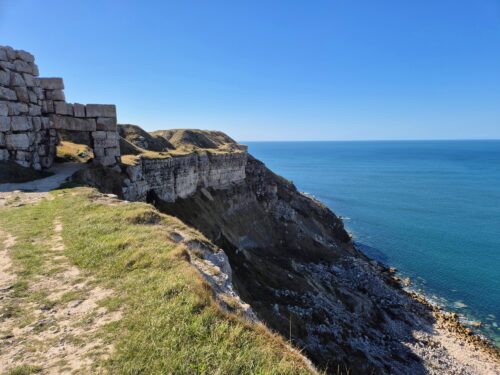
The path led through the park and along the bank of a small river to a footbridge, where it doubled back along the other bank before a short, sharp climb up onto the cliffs. The views back over the beach were particularly lovely, and now that it was getting towards the end of September, there was hardly anybody on it. It would’ve been a different story a month or so earlier!
Once up on the cliff, the route stayed there on a lovely near-flat dirt path along the cliff edge, before ducking slightly inland and down to Hive Beach. I’d had no intention of stopping there, but the cafe looked so appealing that I found myself inside ordering second breakfast before I even realised.
It was the right call, with a tasty bacon and egg bap, decent coffee, and a friendly vibe. I’d go out of my way to call in there again.


From the beach, the path climbed up and over a low cliff: remarkably, that was the last of the climbing for the better part of six miles. I don’t remember that last time that happened!
The first couple of miles of that was lovely and very easy, with a dirt and grass trail ambling towards Cogden Beach and then veering slightly left to pass inland of Burton Mere, a small wetland area that was full of birdlife as I walked by.
Returning back to the coast, however, the fun factor dropped immediately. Depending on who you ask, the entire 18-mile coastline from West Bay to the Isle of Portland is part of a vast shingle bank named Chesil Beach. The size of that shingle changes dramatically west to east, from small pea-sized stones that are easy to walk on to larger stones that are very much not.
The Coast Path route runs along the beach from just after Burton Mere for around three miles, and while there are a few parts where you can stick to the far left edge away from the stones, most of it is a straight, slow slog through deep gravel.
Let’s just say it wasn’t my favourite 90-minute section of the South West Coast Path, tiring and honestly pretty dull. I can usually find some kind of redeeming feature for almost anywhere I walk, but I was struggling here.


If walking on the shingle is doing your head in, a few different footpaths take you inland onto a parallel path that becomes New Lane as it bends up towards Swyre. From there, walk a short distance along the B3157 before heading back towards the coast on Swyre Road, which runs down into West Bexington.
Here, you can either walk back down to the Coast Path and rejoin near the end of the shingle section, or use the South Dorset Ridgeway to loop back inland and then drop down on public footpaths to come into Abbotsbury from the north.
It’s a bit longer, but more interesting and less tiring than walking on or beside the shingle: if you’re out for a day walk and not set on sticking to the Coast Path, I’d definitely consider those alternatives instead. The footpaths from the South Dorset Ridgeway down to Abbotsbury and the Coast Path are signposted, and shown on this map.
I stumbled off the beach shortly after the signpost for the alternate route, onto a path alongside that, while still gravelled, felt like walking on a cloud by comparison. The trail turned into a paved road as it continued, eventually ending at a carpark and cafe that I was very happy to see.
After a cold drink and a lot of procrastination, I continued on along the edge of the carpark and beach to start the long inland detour via Abbotsbury. If you’re an absolute masochist, it’s possible to continue along the endless shingle instead, all the way to the start of the Isle of Portland nearly nine miles away.
I couldn’t recommend this option less, but if you’re still considering it for some reason, just be aware that there’s nowhere to get off the beach once you start, there’s no access between 1 May and 31 August because of nesting birds, and you need to check there’s no firing on the military range at Chickerell at the time.
By contrast, the walk towards Abbotsbury was really quite lovely, a dirt trail through rolling fields with views back over the brackish waters of the Fleet lagoon, protected by the shingle bank that I was very glad to not be walking on.
The official route doesn’t go through Abbotsbury, although there are plenty of footpaths that lead into it if you’re in need of refreshment. I wasn’t, so looped back down past the famous swannery and along New Barn Road, before branching off on a short but unexpectedly steep climb up a hill through the fields.


The views from up here were particularly great, and this mile-long section along the ridgeline was probably my favourite part of the day. Eventually the path took a hard right down the hill and back towards the coast, meandering through fields and little patches of woodland before eventually meeting the lagoon at West Fleet.
It’s a tranquil spot and some sensible person has put a wooden bench there, which I took full advantage of to eat a snack and rest my throbbing feet for a while.
As it turned out, the hard stuff was now done: the last 3½ miles of the day was all on flat, mostly soft trails beside the lagoon. Dark clouds had started to roll in by this point, and it looked for all the world like I was about to get very rained on, but much to my surprise they passed overhead without incident.
Passing Moonfleet Manor, a fancy-looking hotel and restaurant, I noticed a sign that said they welcomed walkers. Given the way I looked and smelled by then, I’m not sure they’d have welcomed this particular walker very much.


Shortly after passing a sign warning of the danger of fast horses (!), and then the footpath leading to St Paul’s church, I spotted a little sign pointing off to the left for East Fleet Farm. That was my intended campsite for the night and I was pretty happy to see it: all that walking on shingle had done a number on my feet and energy levels today.
“It looks like you’ve walked a long way to get here!” said one of the staff at reception a few minutes later, a smile on her face. “Only 600 miles or so” I replied, and at that moment it really felt like it.
Shortly after, and not for the first time on this walk, I was surprised by a remarkable piece of generosity. Finishing up our conversation, my new friend pushed a site map and a tent tag across the counter towards me and said “no charge tonight. Enjoy your stay.”
Thanking her profusely, I almost shed a tear right there and then. There was absolutely no reason for her to give me a free stay: I didn’t ask for or expect any kind of discount. When you’re doing a long walk like this, little acts of kindness like this make an incredible difference.
Just like when that couple that had quietly paid for my lunch a couple of weeks earlier, my faith in human nature was well and truly restored this evening.
After pitching my tent in a near-empty field and having a particularly refreshing shower, I headed for dinner at the onsite pub. Its proximity meant that I would have overlooked a lot of other faults, but luckily there weren’t any: my pint was cold, the food was filling, and there was a power socket I could use to charge my phone while consuming both.
For a day that had otherwise been mostly unremarkable, it really couldn’t have ended up any better!
Get regular travel, hiking, and tech updates from me
News, reviews, guides, and more, from here and around the web
Planning
Started at: Parkdean West Bay (on-trail)
Finished at: East Fleet Farm (on-trail)
Even if the staff member hadn’t been as wonderfully generous as she was, I would still have enjoyed my stay at East Fleet Farm.
Not only is it right on the Coast Path, it had some of the nicest showers and toilets of any campsite I stayed at on this walk. It was very quiet and peaceful towards the end of September: there was one other tent at the other end of the field I was on, and only a few other campervans and caravans dotted around the rest of the site.

My pitch wasn’t perfectly flat but the slope was pretty minor, and many of the others looked to be level. There was a good amount of shelter as well, even if for once the wind wasn’t blowing enough to really need it.
I greatly appreciated the onsite bar/restaurant: it didn’t have a lot of ambience due to the small number of other people staying, but the staff were friendly, the food was absolutely fine, and I didn’t have to walk more than 100 yards to get there. The camp office had a well-stocked shop as well.
Transport and Parking
Public transport is unusually good on this section, with a regular bus service that covers the entire length.
The Jurrassic Coaster (X53) bus stops beside The George in West Bay, and then runs along the B3157 all the way to East Fleet. That road runs roughly parallel to the Coast Path and is never more than a mile from it (often much closer), so you can really decide for yourself where to get on or off.
It stops at several places I mentioned above, including the caravan park near Burton Bradstock, Hive and Cogden beaches, and Abbotsbury. To get to and from the Coast Path from other stops, just use one of the lanes or public footpaths shown on this map.
The X53 operates once an hour Monday through Saturday, once every two hours on Sundays and bank holidays.
That useful bus service also makes this section straightforward if you’re planning to leave a vehicle somewhere and do a bus/walk combo to come back to it later in the day.
West Bay has a surprising number of parking lots for its size: most are short-stay and/or expensive, but the one beside the roundabout on West Bay Road is somewhat more sensibly-priced.
There’s a limited amount of free on-street parking in Burton Bradstock, and National Trust carparks at Hive Beach and Cogden Beach. You may be able to find a free on-street park in West Bexington; if not, there’s a pay-and-display carpark with expensive all-day parking at the beach there.
There’s a cheaper all-day carpark a bit further along the path at the end of the stony beach section beside the cafe where I stopped for a drink, and another similarly-priced one in Abbotsbury, a short distance off the Coast Path. There’s also some on-street parking in Chickerell.
Waymarking and Navigation
Other than me not reading the guidebook properly and missing the detour sign on the way out of West Bay this morning, there weren’t many issues with navigation or waymarking today.
You do need to keep an eye out in a few places, especially through the golf course and Freshwater caravan park early in the day. Make sure you don’t miss where the path goes around the inland side of Burton Mere: I met a guy a couple of days later who hadn’t spotted it, and got to endure even more walking on the shingle beach as a result. He hadn’t loved that.
The inland detour towards Abbotsbury and down past Langton Herring requires a bit of attention as well, as there isn’t always a signpost exactly where you might want it. The rest of the time you’re either walking on or beside the beach, where it’s pretty hard to get lost.
I used AllTrails as my main navigation app for the entire South West Coast Path, and it worked well throughout: you can find the West Bay to East Fleet (and onto Weymouth) section here. The app is free to use, although I pay a couple of pounds a month for a subscription so I can download maps to my phone in advance.
Phone Service
Service with O2 was generally pretty good today: the only place where I consistently had little to no signal was between Abbotsbury and West Fleet as I made my way back towards the coast. There was no issue at either campsite.
As a backup, I’d also paid a few pounds for a data eSIM from Instabridge that let me swap between all three UK networks, EE, O2, and Vodafone/Three. It worked really well as a fallback option all along the Coast Path: if I didn’t have coverage with my usual provider, I’d just switch to another. As long as there were any mobile phone towers in range, I’d have service.
Facilities
West Bay has a few options for breakfast: not all of them open early, but a few do, including the Cornish Bakery where I had a decent pasty and coffee. There’s also a small Nisa Local supermarket at the holiday park where I stayed and a Spar 300 yards up West Bay Road, if you need to pick up supplies for the day.
There’s a bakery and a couple of pubs in Burton Bradstock, but since you have to detour off the path to get to them, I’d be more inclined to eat in West Bay or at the Hive Beach cafe instead. As I said earlier, the latter was somewhere I’d go out of my way to visit again.
After that, there’s The Clubhouse, a fairly expensive restaurant right on the path at West Bexington beach, and Manor, a more affordable one a few hundred yards up Beach Road.
Chesil Beach Cafe was a good place to stop for a drink, right before the path turns inland to head towards Abbotsbury. You’ll need to head around half a mile off-trail to get to the centre of the village, but you’ll be rewarded with several pubs, cafes, and restaurants to choose from if you do.
There’s a Spar supermarket there as well, and also a cafe at the Swannery, right on the path just south of the village.
You could also deviate slightly off-trail on one of the footpaths leading to Langton Herring to visit the Elm Tree Inn: again, it’s about half a mile each way. After that, there’s the high-end restaurant at Moonfleet Manor right on the path, before you get to the onsite bar/restaurant and camp store at East Fleet Farm.
Accommodation
After leaving West Bay there are only two campsites close to the path today, one at either end. The first is Manor Farm in Burton Bradstock, under half a mile from the trail, and close to a couple of different pubs. It’s a small, simple campsite with showers, toilets, and not much else.
After that there’s really nothing close enough to the trail until you get to East Fleet Farm where I spent the night. Slightly further along, you’ve got Seaview Farm Camping, a simple seasonal site that’s only open in July and August.
If you’re not camping, you’ve got a few more choices. The Manor House in West Bexington is a good option with an onsite restaurant, or you could head three-quarters of a mile off-trail to stay at the affordable Lemon Tree Inn in Swyre: there’s a footpath that runs directly to the village from the Coast Path.
This B&B would be my pick of the places to stay in Abbotsbury, and there’s also the Lugger Inn in Chickerell, about three-quarters of a mile off-trail up the footpath and lane you get to just before East Fleet Farm.
Have any thoughts or questions about today’s walk? Feel free to leave them in the comments.
If you’ve got value from this guide, or any of the SWCP guides I link to below, please consider supporting me with a small donation. It takes a long time to write 160,000 words!

All South West Coast Path Guides
Note that I tracked from accommodation to accommodation each day, starting my watch as I left wherever I’d stayed the previous night, and stopping it when I got to my campsite or hotel.
That includes every wrong turn and detour, extra distance to and from my accommodation, and whatever else I did each day that wasn’t on the official trail. As a result, my route maps, elevation chart, and measurements won’t exactly match yours or anyone else’s. Use them as a rough guide only!
Similarly, I can only write about the experiences I had while thru-hiking the South West Coast Path from early August until the end of September 2025. The day of the week, time of year, weather, and other factors affect everything from transport and opening hours to campsite availability and walking difficulty, so check the latest information before setting out.
