
Weymouth to Durdle Door: South West Coast Path Day 47 Guide
Articles on this site contain affiliate links, meaning I may be compensated if you buy a product or service after clicking them. The full privacy & disclosure policy is here.

After another chilly night spent tossing and turning thanks to traffic noise from the nearby A road, I wandered out of the campsite for the 15-minute walk back to Ferrybridge. That’s the point beside the Portland bridge where yesterday’s loop around the island started and finished: today, I crossed the road instead and started off around the bay formed by Portland’s vast harbour.
This first hour into central Weymouth was fast and easy, helped by it being flat and entirely on tarmac. It’s suburban walking, so not always the most attractive, but the path did a good job of sticking to patches of green space and coastline where it could.
The first part was along the Rodwell Trail, a shared path with a steady stream of cyclists heading in both directions. There’s only so much dinging of bells that one person can handle, so I wasn’t sad to see the Coast Path breaking off to the right at Sandsfoot Gardens.
From here the path was on pavement along quiet streets, first Old Castle Road and then Belle Vue Road for two-thirds of a mile until it turned right and into a small park. Passing a stone monument to anti-slavery campaigner Thomas Buxton, I carried on through the park, over a footbridge, and into Nothe Gardens.
This was a pretty little spot, the path looping around the gardens and past the fort and old stone pier at the end. After dropping down some steps on the south side of the harbour, I walked a little further along to cross Weymouth Bridge and start back along the northern side.
I didn’t make it far, though: it was time for breakfast, and the cafes along the harbourfront looked very appealing. I chose Custom House Cafe entirely on the basis that it had a spare table outside; great minds think alike, apparently, as my new friend Mike from last night’s campsite was just coming out as I walked in.
That cafe turned out to be an absolutely inspired choice. Not only did it serve up the best breakfast I’d had on the entire Coast Path, but it was very reasonably-priced for what it was. I made a point of letting the manager know just how good it was before I left, not something I’d felt the need to do anywhere else I’d eaten in the last 6+ weeks! 100% eat here if you’re in need of food on the way past.
The only disappointment was that my table in the sun had turned into a table under thick clouds by the time I finished up: more disappointing still was the fact those clouds then stuck around for the rest of the day.


The area around the harbour was really quite lovely, all attractive historic buildings and small boats bobbing around in the breeze. I’d never been to Weymouth before, but my vague impression of a somewhat tacky holiday town seemed entirely wrong so far.
And then I turned the corner.
Ferris wheel on the beach? Check.
Carnival games alongside? Check.
Toy trains, Punch and Judy shows, and a truly remarkable number of ice-cream shops? Check, check, check.
Still, even on a cloudy day, the endless golden-sand beach was impressive: there weren’t many people out enjoying it this late in the season, but I could still see the appeal.
The Coast Path stays on the esplanade here for a solid couple of miles, past the brightly-coloured Queen Victoria clock that dates back to 1888 and onwards past a long line of three-storey stone buildings on the other side of the road. It’s not the most exciting walking, but it’s easy, doesn’t require any climbing, and has endless places nearby to eat, drink, and resupply if you need them.
The paved path continued along above the beach all the way to Overcombe on the northern outskirts of town, where it briefly joined Bowleaze Coveway before turning right and heading up onto Furzy Cliff. This was also where the tarmac finally ran out: after six miles of it this morning, I wasn’t sad to see it go.
There were some good views back over Weymouth once I got to the top: like a lot of towns, it arguably looks better from a distance than up close. In contrast to the flat, urban scene in that direction, everything looked much more rugged and undulating along the cliffs ahead.


That’s mostly because I couldn’t see the holiday park and funfair down below me, at least not until the route ran straight through them. Closed up for the season, or at least for today, the funfair had a pretty dilapidated air as I passed.
Back up on the cliff, the path then skirted around the edge of an outdoor activity centre: I couldn’t see what was going on there, but I could certainly hear it. There’d been noticeably more up and down since turning off the tarmac: that was set to continue relatively gently for the next few miles and then, as I would discover, a hell of a lot less gently as I got closer to the end.
The empty paths and beaches were a nice change from the busy town I’d left behind; other than a few dog walkers, there was hardly anybody else around as I ambled from cliff to cliff along the grassy trail.
After a solid climb out of Osmington Bay, the path turned briefly inland before emerging onto a quiet lane that headed back to the coast. At the end of the lane sat the tiny hamlet of Osmington Mills, where a Coast Path sign pointed down into the garden of the Smugglers Inn.
I walked inside, just in case the trail ran straight past the bar. As it turned out, it actually goes around the left side of the building, but I was already committed by this stage. I didn’t really need another meal quite so soon after the last one, but safety first I guess. One plate of fish and chips later, I felt much more weighed down energised, and struck out for the second half of the day.
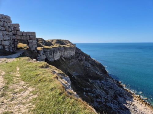
After a quick jaunt through a field and scrubby grassland, I ended up back on the clifftop path before dropping down again to cross a stream at Ringstead Bay. Passing the carpark and cafe (no, I didn’t need a third meal), the path turned off to the right to start the long climb up past a wooden church onto Burning Cliff and towards White Nothe, a headland with impressive views along the white chalk cliffs.
Knowing this was the highest point on the path today, I assumed the remaining three miles of this section would be relatively easy. How wrong I was. While the cliffs between here and Durdle Door were nowhere near as high, they were frequent, very steep, and slippery even when it hadn’t been raining. I can only imagine what they’re like in bad weather.
Still, even with all of those steep climbs and slippery descents, this was easily the best walking of the day. The views were absolutely stunning, with rugged coves and deserted beaches stretched out for miles ahead.


The path itself was gravel and dirt, usually just a narrow trail along the edge of large grass fields. After a steep descent from White Nothe, the path climbed over first Bat’s Head and then Swyre Head in quick succession. Well, quick on the way down, at least. Not so much on the way up.
For the millionth time on this walk, I was very glad of my walking poles: without them, my knees would still be sitting there on the side of the trail somewhere near the immaculately-named Scratchy Bottom. I mean, I don’t know who comes up with these place names, but I take my hat off to them.
Standing at the top of Swyre Head and trying to banish thoughts of haemorrhoid cream from my mind, I noticed two things up ahead of me: a very obvious rock arch in the ocean, and an even more obvious large group of people milling around on the beach nearby.
I guess that’s Durdle Door, then.


In some ways, I think the views from here were even better than those from above the actual archway: you’re higher up, with a better perspective of the cliffs and beach surrounding it. Still, there’s plenty of opportunity to compare them once you get to Durdle Door itself: the Coast Path runs right along the cliff edge, past the viewpoints and close to the stairs leading down to the beach.
Note that part of these stairs were washed away during winter storms in early 2026, and while that doesn’t directly impact the Coast Path, access to the beach itself is currently closed.
After taking a whole bunch of photos, I started the climb up the hill towards Durdle Door Holiday Park. I expected to see some familiar faces tonight, since this is the only campsite anywhere around here, and also the last one before Lulworth Cove, the military firing range a little further along the coast.
That firing range had been dominating my thoughts for the last couple of weeks, since other than Christmas, Easter, and the month of August, it’s only open (most) weekends and bank holidays. The Coast Path runs straight through it, and if it’s shut, you’ve got a long, unpleasant 12-mile walk around it on narrow roads instead.
As a result, I’d been doing some bigger days lately to make sure I got here at the right time. Today was Friday, so it worked out well in the end, even if my legs didn’t necessarily agree right now.
Sure enough, not long after I’d finished pitching my tent, both of the other walkers from last night’s campsite arrived and did the same. More surprisingly, an older guy who I’d walked and camped with a few weeks earlier suddenly appeared as well: I’d last seen him on the outskirts of Plymouth!
Dinner that night was at the onsite bar, and despite its mediocre reviews, I was more than happy with my meal. Given the alternative was walking in the dark to Lulworth village and back, my nachos would have had to be remarkably terrible for that not to have been the right decision. It was also nice to have company for a change, and all the random walking chat that went with it.
Two days to go!
Get regular travel, hiking, and tech updates from me
News, reviews, guides, and more, from here and around the web
Planning
Started at: Martleaves Farm (on-trail)
Finished at: Durdle Door Holiday Park (0.3 miles/0.5km off-trail)
This is the only place to stay anywhere near Durdle Door, and the obvious place to stop for anyone waiting to cross the firing range at Lulworth Cove the next day. It’s primarily aimed at people holidaying in static caravans, campervans, and cabins, but there’s a decent-sized strip of grass set aside for those in tents as well.
It’s a large, popular holiday park with all the amenities, and prices to match if you book ahead. I’d rung a couple of days earlier to make sure I’d be able to stay there, though, and they’d said that as long as you’re happy to take your chances, there was a discount for walkers who just showed up with a small tent.
As a result, I paid £20 for the night: the standard rate if you book ahead is more than double that, at £43 for the pitch even if it’s only one person.
The facilities, as you’d expect, were very good: there’s a clean and fairly modern shower and toilet block near the camping area, and considering the size of the park, it’s not far to either the large camp store beside reception or the Man O’ War bar/restaurant nearby.
I was told to just pick a spot on the grass to pitch my tent, so it wasn’t hard to find a flat, sheltered spot. There are hedges and plenty of trees to help with shelter, and a few picnic tables scattered around: always a welcome sight.
There are USB sockets in the dishwashing area for charging, and the staff at the restaurant were happy to let walkers use the wall sockets as well. There just aren’t that many of them, so set yourself up there early if you’re in desperate need of power.
The free Wi-Fi doesn’t reach to the camping area, but works fine around the restaurant and reception.
Transport and Parking
Public transport isn’t great on this section, although there is a limited bus service between Weymouth and Durdle Door.
The X54 leaves from beside the King’s Statue on the Weymouth waterfront, running up alongside the esplanade to Overcombe before turning inland away from the Coast Path. It stops at a few different places in Osmington, where it’s an easy walk down to rejoin the path at either Osmington Bay or Osmington Mills.
From there, it continues inland along the A353 a long way from the coast, before turning back south near East Knighton to head to Durdle Door and Lulworth Cove.
The bus only runs four times a day, though, and only on weekdays excluding bank holidays. The first service from Weymouth is just after 7 a.m., and the last bus returns from Lulworth Cove at 5:59 p.m.
If you’re starting at the same campsite I did, on the outskirts of Weymouth at Wyke Regis, you can either walk the two miles across town to the X54 bus stop on the esplanade, or take the number 1 (Portland Link) from Portland Road. It runs basically every 15 minutes throughout the day.
If you plan to leave a car somewhere instead, you’ve got a few options.
You should also be able to find parking on side streets around Wyke Regis and near the route of the Portland Link as it goes through the southern part of Weymouth. There are also plenty of paid carparks on and near the esplanade in the main part of Weymouth: the long-stay one beside the train station is probably your best bet.
There’s a carpark in Overcombe, but you’re better off using the one nearby at Bowleaze Cove instead: it’s half the price to park there all day. There’s a pay and display carpark beside the Smugglers Inn at Osmington Mills (you’ll get your money back if you spend 10 or more at the pub), or just park further back on the side of the road.
The path runs alongside a flat-rate private carpark at Ringstead Bay, and there’s also a National Trust one a mile inland. After that, there’s nowhere to park until you get to Durdle Door or Lulworth Cove: they share a parking fee, but are very expensive to park at all day. On-street parking is essentially non-existent in either place, but there’s a (slight) chance you might find something up the road in West Lulworth.
Waymarking and Navigation
Navigation was fairly straightforward today day, with good signage most places you’d expect to see it. It can be slightly tricky picking your way through the suburban streets on the way to Nothe Gardens and Weymouth Harbour, but after that you’ve got a couple of miles straight along the esplanade.
After that, just keep an eye out for markers and signs as you walk along the cliffs: there’s the odd spot where the path detours briefly inland that could be easy to miss. Especially towards the end, though, you can see the path stretched out along the edge of the cliffs in front of you: your biggest concern is likely to be making it up the next hill, not worrying about navigation!
I used AllTrails as my main navigation app for the entire South West Coast Path, and other than brand-new detours like the one above, it worked well throughout: you can find the Weymouth to Durdle Door/Lulworth Cove section here. The app is free to use, although I pay a couple of pounds a month for a subscription so I can download maps to my phone in advance.
Phone Service
Service with O2 was hit and miss today. Even in Weymouth it wasn’t great, and I lost service quite often while walking along the cliffs later in the day as well. There was usually no signal in the coves and lower part of the track, and even being up on the cliffs wasn’t always a guarantee. I did, at least, have service at the campsites at both ends.
As a backup, I’d also paid a few pounds for a data eSIM from Instabridge that let me swap between all three UK networks, EE, O2, and Vodafone/Three. It worked really well as a fallback option all along the Coast Path: if I didn’t have coverage with my usual provider, I’d just switch to another. As long as there were any mobile phone towers in range, I’d have service.
Facilities
You probably don’t need me to tell you that you’ll have no problems finding somewhere to eat, drink, pee, or resupply in Weymouth. I greatly enjoyed my breakfast at Custom House Cafe beside the harbour, which is where several of the better cafes seemed to be, but there are endless options all along the beach promenade as well.
If you’re walking around from Wyke Regis like I was, there are options on the trail before that as well. You’ll walk straight past Sandsfoot Cafe as soon as the Coast Path branches off from the Rodwell Trail, and there’s a cafe (and a pub) in Nothe Gardens as well.
There are a couple of cafes and a Harvester restaurant in Overcombe, and some unexciting options attached to the funfair and holiday park nearby. After that, there’s nothing until you get to the Smuggler’s Inn, where I stopped for a pretty decent meal of fish and chips.
In Ringstead Bay, the Reef Cafe looked good and seemed popular as I walked past. There’s nothing after that until you get to Durdle Door, which has ice-cream vans and some hot food trucks in the warmer months, as well as the camp supermarket and Man O’ War restaurant/bar at the holiday park.
If those places don’t appeal, it’s about a 20 minute walk further along the Coast Path to Lulworth Cove, which has more choices.
Accommodation
There are a few campsites along this section: after leaving Weymouth, the first option is Eweleaze Farm, a seasonal campsite at Osmington Bay that’s only open from late July until the end of August.
It’s the first of a few campsites in the area: of those closer to the trail, Shortlake Farm is run by the same people and only open in August. while Rosewall Camping is open from April to October and has discounted rates for walkers.
There’s also a campsite close to the trail at Ringstead Bay: after that, you’ll be staying at Durdle Door Holiday Park like I did.
If you’re not camping, you’re a bit limited in where you can (affordably) stay. For many people, the best option will be to spend the night in Weymouth, taking the bus one way to/from Durdle Door or Lulworth Cove.
If so, inexpensive places to stay near the path in Weymouth include The Sailor’s Return, The Ocean Guesthouse, the excellent Chapter One beside the beach, and slightly further north, the equally-impressive Redcliff B&B.
The Smuggler’s Inn has nice, if expensive, rooms in Osmington Mills, as do the Castle Inn in West Lulworth and the Lulworth Cove Inn in, well, Lulworth Cove.
Have any thoughts or questions about today’s walk? Feel free to leave them in the comments.
If you’ve got value from this guide, or any of the SWCP guides I link to below, please consider supporting me with a small donation. It takes a long time to write 160,000 words!

All South West Coast Path Guides
Note that I tracked from accommodation to accommodation each day, starting my watch as I left wherever I’d stayed the previous night, and stopping it when I got to my campsite or hotel.
That includes every wrong turn and detour, extra distance to and from my accommodation, and whatever else I did each day that wasn’t on the official trail. As a result, my route maps, elevation chart, and measurements won’t exactly match yours or anyone else’s. Use them as a rough guide only!
Similarly, I can only write about the experiences I had while thru-hiking the South West Coast Path from early August until the end of September 2025. The day of the week, time of year, weather, and other factors affect everything from transport and opening hours to campsite availability and walking difficulty, so check the latest information before setting out.
