Langton Matravers to South Haven Point: South West Coast Path Day 49
Articles on this site contain affiliate links, meaning I may be compensated if you buy a product or service after clicking them. The full privacy & disclosure policy is here.

Finally.
49 days and 700 miles after setting out from Minehead, I woke up inside my little tent for the last time.
I’d slept terribly, just for something different, but it didn’t even matter. With barely thirteen miles to the end and all day to walk them, it really didn’t matter how tired I was.
The drizzle that had contributed to my lack of sleep overnight continued into the morning. I’d been packing away a wet tent pretty much every day for the last few weeks, I guess, so why break with tradition now?
The cafe at the campsite was unsurprisingly busy, so it took a while to get my breakfast bap and coffee, and even longer to work up the motivation to set out into the increasingly-heavy rain.
Mike and I set off together, back across the fields and down the slippery trail to rejoin the Coast Path. Thanks to the rain, the track surface was surprisingly muddy, a thick, claggy goop that stuck to the bottom of my shoes and reduced grip to near-zero every time I went up or down even the smallest of hills. So that was fun.
The low clouds and persistent drizzle didn’t do much for the views, but it did help keep us moving. Once we’d got back to the coast, the path stayed basically flat by the standards of this walk, all the way to the lighthouse at Anvil Head and into Durlston Country Park.
It looked like the landscape would have been spectacular on a different day, but there wasn’t much to see through the gloom this morning. After looping around Durlston Head and past the castle (now a visitor centre), the path turned to gravel as it wound through the woods for half a mile.


After a few short ups and downs, we rounded Peveril Point and found ourselves looking down towards Swanage. I’d been feeling a bit sad that my final day was so damp and grey, but apparently the gods of the South West Coast Path weren’t going to be that cruel: the drizzle stopped and the clouds started to lift as we made our way down towards the foreshore.
Swanage seemed like a nice-enough little place, but with such an autumnal air, there wasn’t much happening on the beach this morning. We marched straight along the sea front towards the end of town, before taking a left to follow the path up Ulwell Road.
Most of the time you can apparently cut out a bit of distance by walking along the beach instead, but I was determined to stick to my no shortcuts rule. Unlike yesterday, Mike grudgingly agreed to come with me, although I’m not sure he was thrilled by our extra half-mile of road walking.
Thrilled or not, we soon ended up back on the coast, walking along what soon became an unexpectedly steep path up some steps, through the fields, and out towards Ballard Down. This was really the only proper climb all day, but it was over soon enough, leaving us up on the clifftop and approaching the most scenic part of this section.
The weather was brightening up nicely as we approached Old Harry Rocks, the bright-white cliffs and offshore rocks that you’ll find in every tourist brochure for this part of the country. Having hardly seen anybody else on the path all day, it was a bit jarring to suddenly come across dozens of other people out for their morning stroll.


As we stood there filling our camera rolls, Brad, my thru-hiking friend from yesterday, walked up alongside. We chatted for a few minutes as we continued on around the headland, before he apologetically sped off to meet his family at the finish line.
Speaking of meeting family, I’d just had a message from Lauren that her mum and her had arrived at a cafe a couple of miles from the end. They’d generously driven down from London this morning to be there at the finish, and I couldn’t wait to see them.
The path by now was flat and wide as we continued on through the outskirts of Studland, past Fort Henry, and on towards the cafe at Knoll Beach. That’s where Lauren and her mum were waiting, so I said my goodbyes to Mike and headed inside for a coffee.
Lauren’s broken heel was on the mend, and while she was still on crutches (and would be for the next three months), she was a lot more mobile than she’d been even a couple of weeks earlier when I’d last seen her.

After a very leisurely flat white, I stood up, grabbed my backpack and poles, and headed back onto the sand. The weather was improving all the time, with the sun now shining brightly and increasing blue sky in every direction.
Strolling past the dunes and along the lovely beach, I found myself drifting down towards the waves. Splashing through the shallows, my mind started to wander as I reflected on the last seven weeks of my life.
Before setting out, everything I’d read had said how difficult the South West Coast Path was, and how important it was not to underestimate it. I’d done all my research and underestimated it anyway: this was, by far, the toughest walk I’d ever attempted.
As it turns out, while climbing and descending the equivalent of Mount Everest four times sounds like a fun little stat when you’re sitting on your sofa at home, it’s quite a lot when you’re doing it.
I’d turned 50 along the way, and was now, without doubt, the strongest and fittest I’d ever been. Distances and ascents that broke me at the start of the walk were now, if not exactly easy, at least a hell of a lot more manageable.
Camping almost every night had added to the challenge, but I was so glad I’d done it. It’s neither affordable nor realistic to try and book 49 days of hotel accommodation in a row during peak tourist season anyway, but the flexibility of being able to decide on a whim how far to walk each day was more than worth the extra weight and discomfort.
It’s a rare privilege to be able to see the world like this, slowly moving through stunning landscapes at two or three miles an hour for weeks on end.
The weather had been predictably unpredictable, blazing sunshine for the first few weeks, gales and rain in the middle, and unexpectedly nice towards the end. I hadn’t always loved it, but it had all formed part of the experience nonetheless.
Lost in the memories, I passed a guy and his young daughter playing in the waves. He looked up, smiled, and said “lovely day for a walk, isn’t it?”
It really, really was.
Turning west around the headland, I spotted Lauren leaning on her crutches near the dunes, her mum standing alongside. Motioning towards the end of the beach a hundred yards away, Lauren stopped me in my tracks with seven simple words.
“Are you ready for it to finish?”
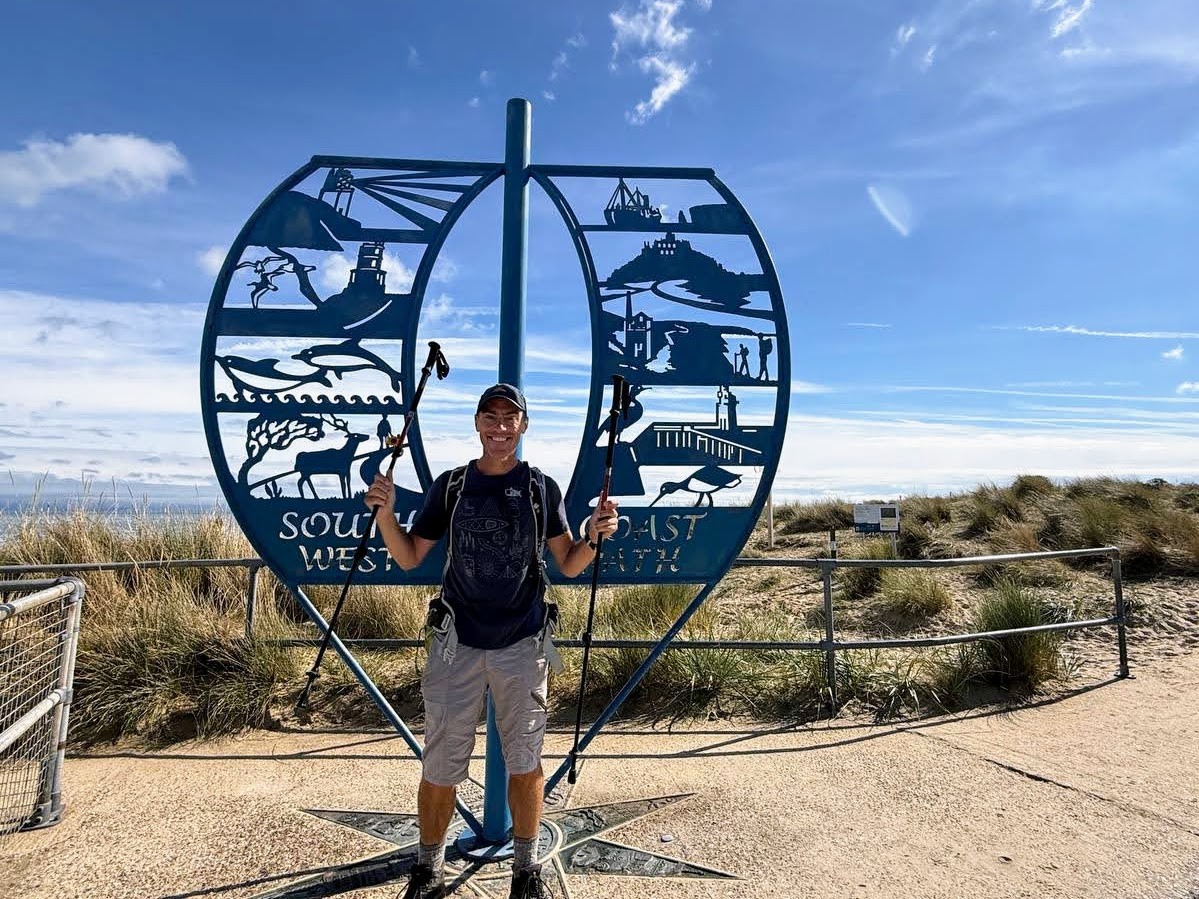
Up until that moment I hadn’t realised exactly where the end point was: apparently I wasn’t ready for it to finish at all. Brad and his family were still standing there chatting after he’d got to the end a while earlier, and they all cheered loudly as I walked up to the blue metal sculpture and wrapped my arms around it.

A rush of emotions suddenly overtook me, and I blinked away tears as I posed for those final photos. Relief, joy, sadness, pride, gratitude, and exhaustion; they all hit like a tidal wave. I may not have been ready for my time on the South West Coast Path to end, but it had done so all the same.
It had easily been the longest, hardest, most beautiful, and most rewarding walk I’d ever done. I now understand why people refer to it as one of the greatest long-distance trails in the world. It unquestionably is.
I hope we continue to treasure and care for this remarkable path, so that generations from now, people can still have all of the joy, pain, and sheer exhilaration I’d just been privileged enough to experience.
Right now, though? It was time for a rest.
Get regular travel, hiking, and tech updates from me
News, reviews, guides, and more, from here and around the web
Planning
Started at: Tom’s Field (1.2 miles/1.9km off-trail)
Finished at: South West Coast Path end point, South Haven Point
Transport and Parking
Public transport is reasonably good on this final section, although there’s nothing on the Coast Path itself until you get to Swanage.
If you’re starting in Langton Matravers like I did, the number 40 bus runs cross-country from there along High Street into Swanage. If you’re starting in Worth Matravers instead, walk up Worth Lane for a mile to the intersection with High Street, and catch the same bus from there.
From Swanage, the number 50 runs inland to Ulwell before returning to the coast at Studland and then onward to the ferry jetty at South Haven Point.
That’s where the South West Coast Path ends, but if you’re continuing on to Bournemouth to catch onward transport or spend the night, just stay on the same bus. It will take you across on the ferry to Sandbanks and then into Bournemouth town centre, finishing beside the railway station.
Both buses run every day, roughly once an hour. Just double-check the timetables if you’re planning a particularly early or late journey, as the first and last service times vary by day.
If you plan to leave a car somewhere instead, you’ve got a few choices.
There’s a free parking lot close to Langton Matravers on Acton Lane, as well as the Spyway National Trust carpark south of the village. You may also be able to find free on-street parking in the village, although it’s quite limited. Similarly, there’s a small amount of on-street parking in Worth Matravers.
You’ll also find all-day parking right beside the path at Durston Country Park, and there are half a dozen different carparks in or just outside Swanage. Long-stay options include Broad Road (near the path just south of town), North Beach, and Main Beach carparks: North Beach is slightly cheaper than the other two. There’s also some free on-street parking away from the beach.
From here on, it’s National Trust carparks all the way. You’ll find two beside the path in Studland (for Old Harry Rocks), one at South Beach and the other very close by at Middle Beach. Knoll Beach has one behind the cafe I stopped at for coffee, and finally there’s one close to the ferry at the end of the walk.
There’s also on-street parking all along Ferry Road, but it fills up pretty quickly in summer.
Taking the Ferry
Technically the short ferry crossing from South Haven Point to Sandbanks isn’t part of the South West Coast Path, but unless you’re as lucky as me and have someone picking you up from the end, chances are you’ll be taking it.
Slightly up the road from the sculpture that marks the end point, this chain ferry takes both vehicles and pedestrians. It runs every 20 minutes throughout the day, with the first service from South Haven Point at 7:10 and the last at 11:10 p.m.
The crossing takes all of four minutes, and pedestrians travel free if they’re heading towards Sandbanks (it’s £1 in the other direction, payable by card or cash at the ticket booth).
As I mentioned above, the number 50 bus that runs to Bournemouth uses this ferry, so feel free to get on/stay on that instead if you’re heading further afield.
Waymarking and Navigation
Navigation was easy today, helped by a good chunk of the walking just being along the beach at the end. The only place where things got a little confusing (or at least, poorly-signposted) was around Durlston Country Park. As usual with the Coast Path, when in doubt just take the path closest to the edge of the land and chances are you’ll be going the right way!
I used AllTrails as my main navigation app for the entire South West Coast Path, and it worked well throughout: you can find the section from Langton Matravers to Swanage here, and the final section from Swanage to the end here. The app is free to use, although I pay a couple of pounds a month for a subscription so I can download maps to my phone in advance.
Phone Service
Service with O2 was pretty good today, especially from Swanage onwards. It was more intermittent before that, especially the first section along the cliffs towards the lighthouse, but I still largely had signal when I needed it.
As a backup, I’d also paid a few pounds for a data eSIM from Instabridge that let me swap between all three UK networks, EE, O2, and Vodafone/Three. It worked really well as a fallback option all along the Coast Path: if I didn’t have coverage with my usual provider, I’d just switch to another. As long as there were any mobile phone towers in range, I’d have service.
Facilities
Unlike several other sections of the Coast Path, you’re not going to struggle to find food or drink today, especially during the latter part of it.
If you’re staying in Langton Matravers, the best place to get breakfast in the morning is the cafe at Tom’s Field, the campsite I stayed at.
The next place to find food is Durlston Country Park, where you’ll find the Seventh Wave cafe beside the path at Durston Castle. Swanage has a wide variety of cafes, pubs, and restaurants along the promenade, mostly on the southern end as you come into town. There are also a couple of supermarkets close to the path, a Morrisons and a Budgens.
Studland has cafes, tearooms, and pubs all very close to each other, and your last place for refreshment on the South West Coast Path is at Knoll Beach Cafe, where I stopped for a coffee. There’s also a cafe and a seafood restaurant on Ferry Road, just after the end point.
Accommodation
While most people walking this section won’t need them, there are a couple of campsites in or near Swanage. Swanage Bijou Camping has a short season (late July to early September), while Ulwell Holday Park is open most of the year and has reduced rates for walkers.
Even if you’re not camping, Swanage is still your best bet for affordable accommodation. Good options close to the path include the Red Lion, Purbeck House, or a private room at the YHA at the south end of town, or The Pines Hotel at the north end.
If you need a night’s accommodation after you’ve finished the path before starting your onward travel, both Poole and (especially) Bournemouth have plenty of good, inexpensive places to stay near the bus and train stations.
Have any thoughts or questions about today’s walk? Feel free to leave them in the comments.
If you’ve got value from this guide, or any of the SWCP guides I link to below, please consider supporting me with a small donation. It takes a long time to write 160,000 words!


All South West Coast Path Guides
Note that I tracked from accommodation to accommodation each day, starting my watch as I left wherever I’d stayed the previous night, and stopping it when I got to my campsite or hotel.
That includes every wrong turn and detour, extra distance to and from my accommodation, and whatever else I did each day that wasn’t on the official trail. As a result, my route maps, elevation chart, and measurements won’t exactly match yours or anyone else’s. Use them as a rough guide only!
Similarly, I can only write about the experiences I had while thru-hiking the South West Coast Path from early August until the end of September 2025. The day of the week, time of year, weather, and other factors affect everything from transport and opening hours to campsite availability and walking difficulty, so check the latest information before setting out.
