Axmouth (Seaton) to West Bay: South West Coast Path Day 44 Guide
Articles on this site contain affiliate links, meaning I may be compensated if you buy a product or service after clicking them. The full privacy & disclosure policy is here.

I’d loved the clear skies yesterday, but this late in September, they made for cold overnight temperatures and a lot of dew on the tent. I’ll take that over clouds and rain, mind you: I’d had more than enough of that lately.
There was a bit of time to let things dry out in the sun this morning anyway, since Quayside Cafe where I was planning to have breakfast in Axmouth harbour didn’t open until 9 a.m. After a decent cheap meal and a lot of fishing chat from the other patrons, I rejoined the path and took a right up Squire’s Lane towards the golf course.
Tell you what, if you want to get the blood pumping first thing in the morning, that’s a great road for it. I’ve owned cars in the past that definitely wouldn’t have made it up that hill.
Levelling out somewhat at the top, the path then ran past the clubhouse and along the fairway on what was already a beautiful blue-sky day. A few people were already hard at work slicing their tee shots into the rough, but I didn’t have to avoid low-flying golf balls for too long before the path headed off to the right beside a large warning sign.


After here, there’s nowhere to get off the path for another five miles until you get close to Lyme Regis. Almost all of that distance is through the Undercliff, the site of a massive cliff fall back in 1839 that’s sat undisturbed ever since and is now a nature reserve. All dense woodland and gloomy trails, it feels completely different to anywhere else on the entire South West Coast Path.
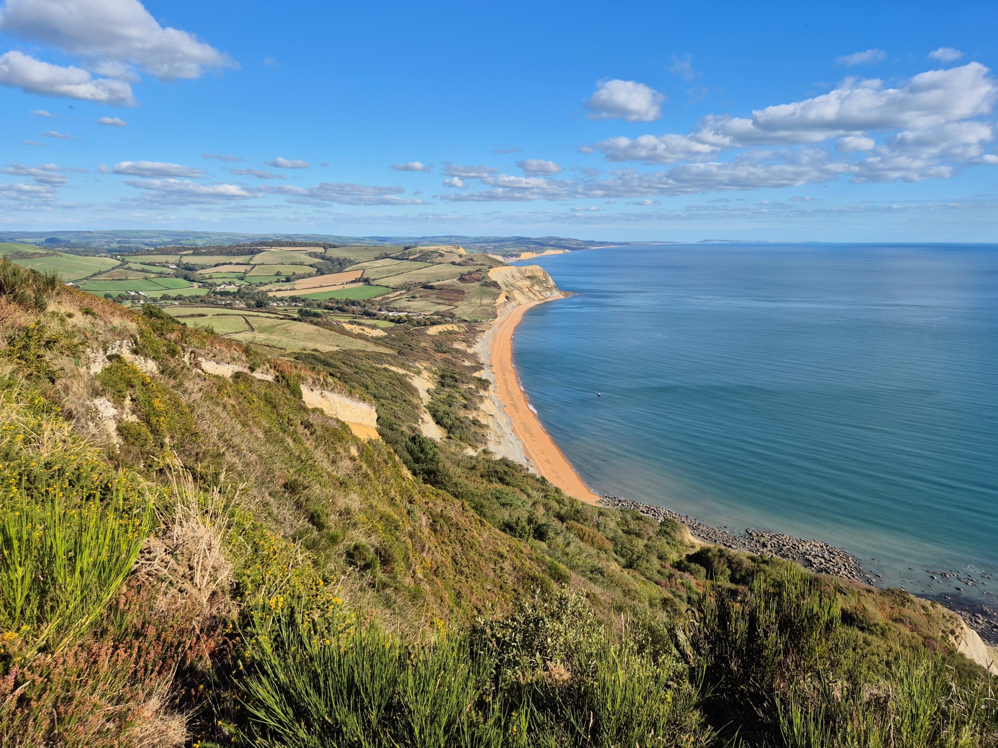
From there I meandered through a tunnel of trees back towards the coast, before passing a sign marking the start of the reserve and emerging into a wide, grassy area with expansive views over the ocean, a stark contrast to the trees and hedges all around it.
Despite the huge number of molehills, this area is actually called Goat Island. I’m not entirely sure why, since it’s not an island and there are no goats, but I guess I wasn’t on the naming committee.
Be sure to appreciate those expansive views when you’re walking through here: they’ll be the last ones you get for a good two or three hours. The path soon led back into heavy tree cover, with even today’s bright sunshine struggling to break through the canopy.
The Undercliff is apparently quite a polarising section of the Coast Path: some people love it, others really don’t. I fell strongly into the first camp, maybe because the rainforest vibes reminded me a lot of hiking in New Zealand, maybe just because after six weeks of coastal views, it was nice to have something different to look at for a few hours.
I haven’t walked in many other places in the UK that have felt quite so untouched, at least not for hours at a time. There’s always been some kind of sign of civilisation nearby, even if it’s just farmer’s fields or a road in the distance.
Other than information boards and the path itself, there really wasn’t much here at all. For the last 185 years, nature had just been quietly doing what nature does, steadily eroding most signs of human existence.
Occasional signposts pointed off down a side trail to some point of interest or another, mostly geological in nature. Washing Rock, for instance, is so-named apparently because it used to be regularly covered with whitewash as a shipping aid. Interesting fact for the day.


The trail itself was almost entirely dirt, often quite rough thanks to rocks and tree roots, but with very little mud anywhere. There were only a couple of proper climbs and descents along the route, but pretty much continual small ones: whoever had the job of building steps for this section of trail had their work cut out for them.
The forest opened up a little as I got towards the halfway point at Rousden Cliffs, enough to see the stunning beaches below. They’re completely inaccessible if you don’t have a boat, but they’d be a fantastic place to spend the day if you did.
After a bit of a climb I came across a tall brick chimney, which was quite jarring after looking at nothing but trees and rocks for the last hour or more. It’s the remains of a coal-fired pumping station, used to send fresh water to the Peek mansion higher up the cliffs, and a reminder that this area was well-utilised in Victorian times right up until that landslip.
The second half of the Undercliff felt a bit easier and slightly more open than the first, other than one fairly steep descent and climb along the way. It was no less attractive for that, especially the boardwalk section above Pinhay Bay.
There are actually two paths you can take here: the upper one is signposted as the South West Coast Path, the lower as a permissive path via Pinay Warren. I took the official route, but they join back up again further along, so feel free to choose whichever one takes your fancy.
The Undercliff ended abruptly, emerging onto a paved lane for a short time before returning to a dirt path along the cliffs and down to Monmouth Beach on the outskirts of Lyme Regis. I was looking forward to some lunch, but sad to leave the forest behind: it really had been one of the highlights of the Coast Path for me.
Somewhere around here I also crossed into Dorset, the final county on my Coast Path adventure. I’d have probably felt slightly more excited about that if I’d had the faintest idea at the time.
Regardless of which county it was in, the path now ran past the Cobb harbour and right along the beach promenade in Lyme Regis, ice-cream and takeaway kiosks popping up like mushrooms after autumn rain as I got closer to the town centre. Climbing up steps at the end of the beach, I chose the Lyme Bay entirely on the basis that I’d seen its outdoor tables as I walked past.
One fish finger sandwich and pint of lime and soda later, I strolled back out again, past the museum and up the main road out of town. This was the start of a mile of solid climbing: it wasn’t particularly steep, but it was certainly consistent as I crossed a field, headed through sparse woodland with a maze of different paths, and emerged back on the main road.


This was all part of a big three-mile inland diversion to avoid (wait for it) major cliff falls back in 2001. There’s apparently no way of restoring the original trail along the coast, so this is now the permanent route. It certainly adds to the distance, if not necessarily the enjoyment.
Still, on this lovely sunny day, I wasn’t exactly sad to be wandering through what I liked to think of as a large green parkland, and the people zipping around on golf buggies nearby probably thought of as something else entirely. The diversion used to go along the road for quite some distance before the golf club agreed to let walkers come through here, so I had to thank them for that.
Following the white markers, I ended up on a gravel path through yet more woods, running along the edge of the golf course past a long chainlink fence. The views were impressive out towards Charmouth, which I started descending towards at pace along what was now a fairly steep downhill.
Emerging at a lane on the edge of town, I’d thought about stopping for a quick snack, but the cafe was just a bit too far off-trail to bother in the end. Instead I continued on downhill to the coast and grabbed a Coke from the small kiosk on the beach, in a vain attempt to fortify myself for what I could see lay up ahead.
There’d been a bit of climbing already today, but it was nothing compared to what was in store. While my minimal research had noted the fact that I’d be crossing over Golden Cap, the highest point on England’s south coast, I’d somehow missed the half-dozen other major climbs before and after that. Whoops.
The fun started as soon as I left the cafe, crossing a footbridge across the river and heading straight up the next hill. The views back over the beach and town were something else, and I got to see plenty of them, every one of the many times I stopped to catch my breath.


The path meandered slightly inland to avoid an obvious landslip down the cliff alongside, and them back towards the coast again as it neared the top. I could see Golden Cap up ahead, but there were a couple of valleys to negotiate first, one of them so steep that I decided the best choice for my knees was to just jog down it.
I’d spotted a couple of dots in the distance, which turned into human shapes as we drew closer to each other. Eventually crossing paths with them at the base of Golden Cap, one of them asked if it was me they’d seen running down the hill earlier, their tone of incredulity suggesting exactly what they thought of that approach.
When I said that it was, they laughed, and suggested that I probably wouldn’t be doing much running for the next little while.
They were correct.
The path up Golden Cap doesn’t look that bad from ground level, but those looks are deceiving. It’s long, very steep, and mostly just a straight slog up the side: it’s not until right near the top that the trail creators take pity on you and put a few switchbacks in to make things slightly easier.
Having already walked 15 miles to get here, my legs had strong opinions at this point, but all was forgiven once I got to the top. On a path that’s full of incredible viewpoints, on a day like today the top of Golden Cap surely has to be in the running for the best of the lot.
I lingered for a while at the top, taking photos, sucking down water, and pretending that time wasn’t ticking by and I really didn’t have to get a move on. The path down the other side wasn’t quite as steep for quite as long, but there wasn’t much in it. It’s a proper workout, that hill.


I’d been consoling myself on the way down with the fact that I could see the campsite I was shooting for in Seatown. Imagine my disappointment, then, when I walked into the office of Golden Cap Holiday Park to be told the camping area had closed at the start of September.
My suggestion that I’d be happy to pitch on literally any 2m2 patch of grass fell on deaf ears: I apparently just couldn’t camp here tonight. Cool.
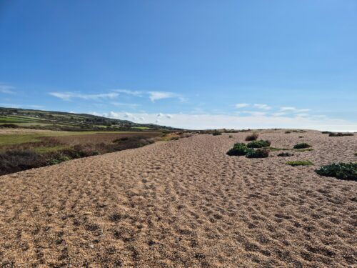
Onwards I plodded on tired legs, up and over Thorncombe Beacon and down the other side. To be fair, that’s a hill I could probably have done without by this point. After a couple of miles I arrived beside the beach in Eype, which is also the noise I made after finding out the small caravan park alongside had nowhere to pitch a tent.
I was starting to run out of options now: the only campsite left anywhere nearby was the vast Parkdean holiday park in West Bay, another mile or so further along the path. In my experience these aren’t the kinds of places that love random walkers showing up late in the day looking for somewhere cheap to stay, but I didn’t have enough signal to make a phone call, so 🤷.
It was just before 6 p.m. when I arrived at a firmly-closed reception, the security guard a little nonplussed when I asked if there was some way I could stay there tonight. To his credit, he went and found the general manager who’d been on his way out the door, and after some discussion about exactly how the process might work, settled on me handing over a £20 note and him figuring it out later.
My little tent looked rather out of place in a sea of campervans and chalets, but after walking the better part of 20 miles today, I couldn’t have cared less. I managed to pitch, have a shower, and find my way to the nearby pub before I completely lost the light, which was a far better outcome than I’d been expecting an hour earlier.
The final cherry on the top of my day was chatting to the barman at The George, who turned out to also be from New Zealand. When I asked which of the two ciders on tap was better, he said “do what the locals do, mate: half and half”.
Apparently it’s such a common request, he even had a button to specifically ring it up. I mean, with a recommendation like that, how could I say no?
The locals were right. It was bloody great.
Get regular travel, hiking, and tech updates from me
News, reviews, guides, and more, from here and around the web
Planning
Started at: Axmouth Caravan and Camping Site (0.7 miles/1.1km off-trail)
Finished at: Parkdean West Bay (on-trail)
I’d tried to avoid large holiday parks like this throughout this walk: they tend to be busier, louder, and more expensive than the smaller places, assuming they have somewhere to pitch a tent at all.
With no other alternatives, however, I ended up here: while it fit all three of the above criteria, I have to thank both the security guy and the general manager for going out of their way to make sure I had somewhere to sleep at all.
The showers and toilets were clean and worked well, and I filled my water bottle from a tap on the way out the next morning: other than that, the rest of the facilities and entertainment options remained a mystery.

You can’t fault the location either: right on the trail, and just down the road from takeaway shops and pubs for dinner and a decent bakery for breakfast.
As I mentioned above, I paid £20 in cash to stay the night: that’s about what the official rate is meant to be for one person, but you can’t book for a single night online. I’d suggest calling up in advance, or just doing what I did and rolling the dice: try to arrive a bit earlier than me either way!
Transport and Parking
Public transport isn’t too bad on this section: just don’t forget that you can’t get on or off the Undercliff between Seaton and the outskirts of Lyme Regis.
The quickest option for getting between those two towns is the 378 bus. If you’re staying at the campsite in Axmouth, there’s a stop opposite the Ship Inn so you don’t need to walk back into Seaton first.
From Lyme Regis, the Jurrassic Coaster (X53) bus runs to the top end of Charmouth; from there, it’s a 10-minute walk down to the beach to rejoin the path.
It’s a similar story for the rest of this section, since that route continues inland but parallel to the coast along the A35. You can get on or off almost anywhere the bus stops along that road, you just need to be prepared for a bit of a choose-your-own-adventure to get between there and the Coast Path. Use this map to find public footpaths and rights of way as needed.
That bus route doesn’t rejoin the coast again until West Bay, which is where I ended my day.
From 1 May to 26 September, there’s also the LB1 evening service that runs between Bridport and Lyme Regis, covering part of the X53 route after that bus stops for the night. It only runs on Friday and Saturday nights, once every 90 minutes.
The 378 runs five times a day in winter, six in summer, Monday through Saturday excluding bank holidays. The X53 operates once an hour Monday through Saturday, once every two hours on Sundays and bank holidays.
If you want to leave a vehicle somewhere and come back to it later in the day, there are plenty of places to do so (again, other than along the Undercliff).
Seaton has several carparks, but most are only for shorter stays. Seaton Jurassic offers all-day parking, as does nearby Underfleet West which is only open at peak times. The Grove is likely to be your best bet for long-stay parking, though, as it’s generally a bit cheaper than the others.
There are no parking lots in Axmouth, and minimal on-street parking as well. I’d suggest leaving the car in Seaton instead.
Affordable long-stay parking options in Lyme Regis are in very short supply, with most parking lots being either short stay or very expensive. The best of a mediocre lot is the furthest out of town but right on the path, up Charmouth Road. Holmbush is closer to the centre of town but costs quite a bit more.
In Charmouth, the best option is this carpark beside the beach and Coast Path, which has reasonable all-day parking rates. There’s another carpark further up Lower Sea Lane with similar rates, but since it’s further from the path, I’d only use it if the other one is already full.
There’s a National Trust carpark a couple of hundred yards off the trail at Stonebarrow, and private carparks with all-day parking beside the beach and Coast Path in both Seatown and Eype. West Bay has a surprising number of parking lots for its size: most are short-stay and/or expensive, but the one beside the roundabout on West Bay Road is somewhat more sensibly-priced.
Waymarking and Navigation
It’s hard to get lost during the first part of the day: as long as you spot the sign and turn-off to the right from the golf course outside Axmouth, it’s pretty much a single track through the Undercliff all the way to the cliffs on the outskirts of Lyme Regis.
There are a couple of different ways to get down into the town itself, but the official route is waymarked and easy to follow: from there, you just follow the esplanade all the way along the beach.
Things get trickier on the other side of Lyme Regis, due to all the diversions in place. That’s not helped by the many paths through the woodland on Timber Hill, where the waymarking isn’t always the greatest.
Keep an eye out for the white stone markers while you’re crossing the golf course; they mark not only the permitted route, but also the one where you’re less likely to get hit in the head by a golf ball. Wait for people about to tee off, and wave if you think they haven’t seen you.
Once I’d navigated through the streets and down to Charmouth Beach, the path was generally straightforward from there all the way to West Bay: you can see a long way from the (many) high points and the trodden path is pretty visible, at least in good weather.
I used AllTrails as my main navigation app for the entire South West Coast Path, and it worked well throughout: you can find the Seaton/Axmouth to Seatown section here, and Seatown to West Bay (and on to Abbotsbury) here. The app is free to use, although I pay a couple of pounds a month for a subscription so I can download maps to my phone in advance.
Phone Service
Service with O2 came and went throughout the day, with not much along the Undercliff (especially the middle section) but better coverage after that. The good thing about having so many hills between Charmouth and West Bay was that if I didn’t have signal down in a valley or cove, I didn’t need to wait long until I’d be back up high again! There was no issue at either campsite.
As a backup, I’d also paid a few pounds for a data eSIM from Instabridge that let me swap between all three UK networks, EE, O2, and Vodafone/Three. It worked really well as a fallback option all along the Coast Path: if I didn’t have coverage with my usual provider, I’d just switch to another. As long as there were any mobile phone towers in range, I’d have service.
Facilities
If you’re staying in Seaton, there are plenty of choices for breakfast: just find one that appeals and opens early enough for you. There’s also a large Tesco on Harbour Road, as well as a Londis, Aldi, and Spar elsewhere in town.
If you’re starting from the campsite in Axmouth, the closest option is the no-frills Quayside Cafe on Axmouth harbour, which opens at 9 a.m. The pod coffee wasn’t much to get excited about (although it was cheap), but their version of a full English set me up for the day just fine.
That was fortunate, since there’s nothing for the next six miles along the Undercliff until you get to the Lyme Regis. There, obviously, you’ve got a wide array of places to eat and drink: along the esplanade is the usual range of takeaways and ice cream sellers, but there are several decent pubs and restaurants at either end and up on the main street. My fish finger sandwich at the Lyme Bay was more than acceptable.
Charmouth has a handful of pubs and cafes scattered along the main road (literally named The Street, which I personally love). They were all slightly too far off-trail for me to deal with today given how far I had to walk, but if you’re doing a shorter day or have more energy than I did, the Bank Cafe looks particularly good.
Instead I bought a Coke from a surly staff member at the beach kiosk who definitely gave the impression she was ready for the summer tourist season to end. Speaking of warmer months, there’s often also a souvlaki van parked up in the carpark alongside at that time of year.
There’s nothing after that until you get to the Anchor Inn in Seatown; there’s also a small supermarket at reception in the nearby holiday park. There’s a cafe just up the lane from the Coast Path in Eype, and from there it’s about a mile to West Bay and its array of options. I mentioned the excellent half-and-half cider at The George earlier, and my fish and chips were just as good.
Accommodation
As with everything else along the Undercliff, there’s no accommodation on or accessible from the trail between Seaton and Lyme Regis. If you’re camping, you’ll need to continue on a bit further than that to either Berries Farm Camping (close to the trail, but also on a busy A road) or Cummins Farm, half a mile off-trail. Manor Farm is a bit further along in Charmouth, again about half a mile off the trail.
There’s (expensive) camping available in a separate field at Golden Cap Holiday Park in Seatown, although as I discovered, it’s a pretty limited season: don’t count on it being open after the end of August. They apparently rent the field from a local farmer, who wants it back after that. Or so I was told.
The holiday park in Eype no longer has tent sites, so you’ll need to carry on to the large Parkdean holiday park in West Bay where I stayed. There’s also Britt ValleyCampground, 500 yards up West Bay Road: it’s only open for a couple of months a year (early July to early September) so I couldn’t stay there, but you may be able to.
If you’re not camping, The Nags Head in Lyme Regis often has the most affordable accommodation in a town that’s not exactly renowned for it, while The Royal Lion and Room at the Inn are generally more expensive but closer to the path.
It’s painfully difficult to find an affordable single-night stay in Charmouth in the warmer months: this motel room in the Newlands holiday park a little way of town is about as good as it gets.
The Anchor Inn in Seatown has a few rooms, and there’s a good hotel about 300 yards up the lane from the trail in Eype. After that you’re in West Bay, where The George has reasonably-priced rooms if you needed any more reason to go there.
Have any thoughts or questions about today’s walk? Feel free to leave them in the comments.
If you’ve got value from this guide, or any of the SWCP guides I link to below, please consider supporting me with a small donation. It takes a long time to write 160,000 words!

All South West Coast Path Guides
Note that I tracked from accommodation to accommodation each day, starting my watch as I left wherever I’d stayed the previous night, and stopping it when I got to my campsite or hotel.
That includes every wrong turn and detour, extra distance to and from my accommodation, and whatever else I did each day that wasn’t on the official trail. As a result, my route maps, elevation chart, and measurements won’t exactly match yours or anyone else’s. Use them as a rough guide only!
Similarly, I can only write about the experiences I had while thru-hiking the South West Coast Path from early August until the end of September 2025. The day of the week, time of year, weather, and other factors affect everything from transport and opening hours to campsite availability and walking difficulty, so check the latest information before setting out.
