Durdle Door to Langton Matravers: South West Coast Path Day 48 Guide
Articles on this site contain affiliate links, meaning I may be compensated if you buy a product or service after clicking them. The full privacy & disclosure policy is here.

I was up and going early this morning, knowing I had a long day ahead. What I didn’t quite expect was that my second-to-last day on the South West Coast Path would have more climbing and longer distance than any other day of my entire walk. So much for coasting into the finish line!
After grabbing sandwiches from the camp store, I set out towards Lulworth Cove with Mike, my friend from the last couple of days. It was only a mile or so into the village, a bit more to the cove itself, and an attractive walk this morning despite the clouds and drizzle.
The cove itself was absolutely lovely, unusually round and sheltered, and the path gave plenty of vantage points to appreciate it on the way down.
We hadn’t expected anywhere to be serving food when we arrived, but based on the number of locals walking in and out, the Boat Shed very much was. No egg mayo sandwiches for breakfast for this guy: instead, a strong Americano and a tasty Full English. I definitely needed the calories today.
We got a bit confused after leaving the cafe: people with backpacks were picking their way over a landslip halfway along the beach, and with no signage to indicate otherwise, we set out after them.
After a few steps I did a quick double-check of the guidebook, and I’m pleased I did: it turns out the official route runs back up out of the village and does a big loop above the cove. The beach route is a shortcut, and a popular one despite the landslip.
I’d had a “no shortcuts” rule the entire walk, and wasn’t about to break that now. Mike, on the other hand, wasn’t set on making life unnecessarily difficult for himself, so he carried on along the beach as I turned and trudged up the tarmac instead. Feel free to make your own decision about it: taking the official route adds about a mile.
The first part of the loop around the cove wasn’t very exciting, just walking alongside Main Road out of the village as far as Bindon Road, then turning off into a grassy field. It’s a fairly steep climb from there up and along the field, but the views over the cove made up for it: they were picture-perfect despite the low clouds.


Just when it felt like the path was about to level off, it instead dropped sharply down hundreds of wooden steps towards the far edge of the cove, where it joined the rough path coming up from the beach. I was glad I’d taken the proper route, even with the extra distance: the views were far better from up on high.
From there, it was barely five minutes until I reached the metal gate at the start of the military firing range that had dominated my thoughts for the last couple of weeks. Only open (most) weekends this time of year, I’d had to time my walk just right if I didn’t want an unpleasant 12-mile detour along the road instead.
Today was Saturday, so the gate was unlocked and the flags weren’t flying. Outside August, Easter, and Christmas when it’s certain to be open, double-check before planning your walk!
The safe walking path through the range is marked by yellow posts: they’re the only area that’s fully checked after live firing exercises. It’s a good idea to stay between them if you’d prefer to retain all your body parts.
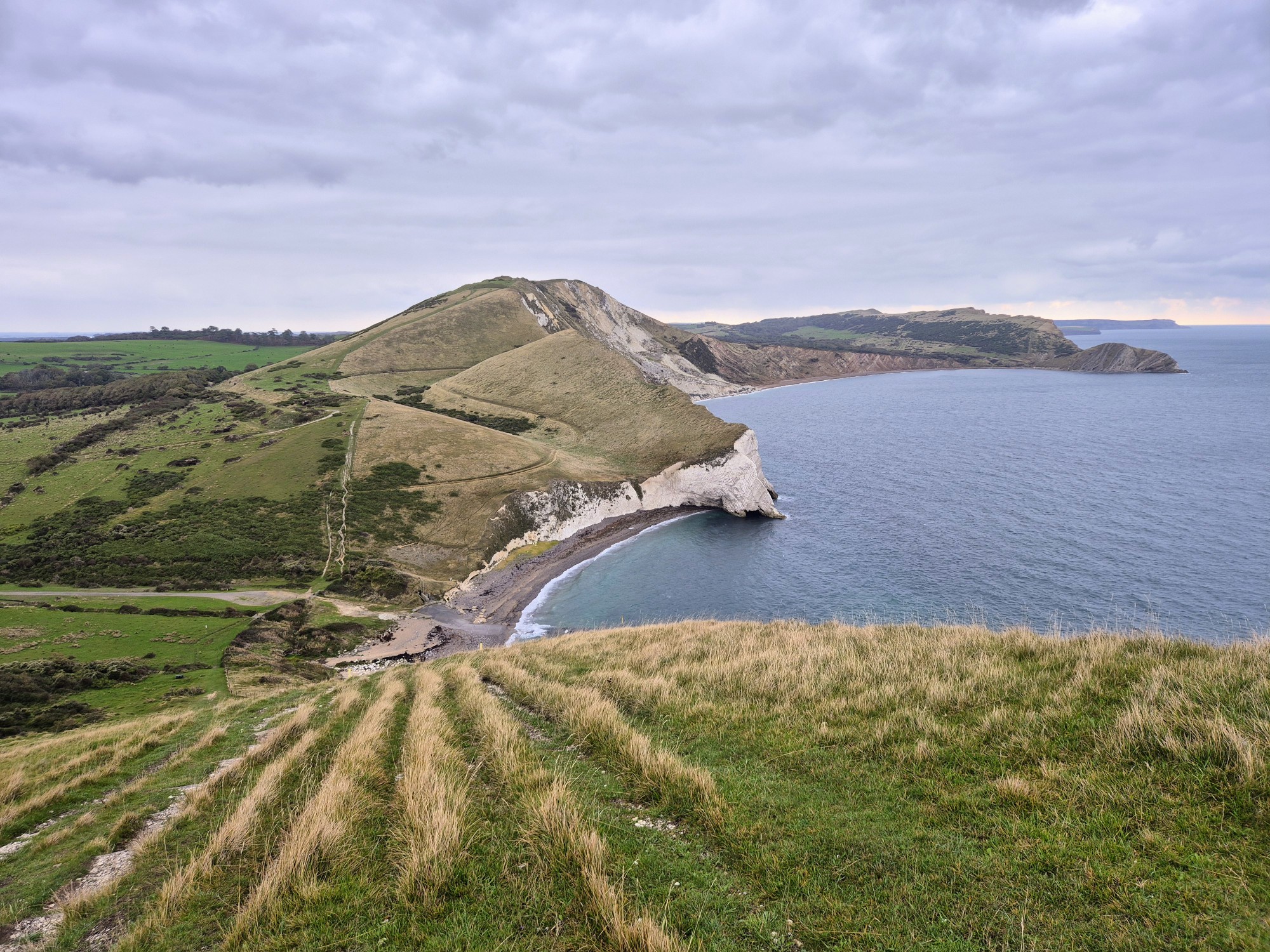
The first mile after the gate was deceptively flat and easy, a lovely gentle stroll along a grass trail above the ocean. It had me wondering why this section was one of the few marked as “severe” in the guidebook, but I didn’t have to wait long to find out.


Turning north past Mupe Bay, I couldn’t help but notice the tall cliff rising in front of me and the rough path leading straight up the side of it. Take a look at the elevation chart up above for some idea of just how hilariously steep it was: it’s the first of the two near-vertical climbs around the 7-8km mark.
As exhausting as it was, though, I was loving the day so far. While clouds and occasional drizzle isn’t my preferred walking weather, it did make for much cooler temperatures. After tackling some of the harder climbing sections towards the start of the Coast Path in 30+ degree sunshine, I wasn’t sad to not have that today.
After pausing to catch my breath at the top and gaze out towards Lulworth Castle in the distance, I started back down to cross a small bridge beside the beach at Arish Mel. The first few hundred yards of descent were nice and gentle. The last hundred were very much not.
There’s definitely no respite on this section: it really does feel like you’re either going sharply up or sharply down, with very little in the middle.
Just before starting down the slippery grass trail towards the beach, I’d noticed a lone backpack-wearing figure coming up quickly behind me. He’d caught me up by the time I got to the bottom, and introduced himself as we started climbing up the even steeper cliff on the other side.
It turned out Brad was also walking the path end to end, only the second other person I’d met in the last seven weeks who was doing so. I’m sure there were others I just hadn’t run into, but also it was pretty late in the season: most people tackling the whole path apparently start in spring, not late summer.
It was kinda nuts just how much quicker time seemed to pass from having another thru-hiker to chat to, and how much less I noticed the difficulty of the trail. Brad was definitely a faster walker than me, but he kindly pretended otherwise: I think he was glad of the company as well.
The climb up to the top of Rings Hill was no less steep than what preceded it, and the summit even higher. Likewise with the drop down to Pondfield Cove: my knees had some opinions they were pretty keen to share by the time we got to the bottom. They were soon silenced by my quads, which took over the complaining as we immediately started back up the third cliff in a row.


The path finally flattened out once we got to the top, at least for a while, which gave me a bit of time to appreciate how much fitter I must have become over the course of this walk. This section would have damn near killed me if I’d walked it in the first week; now, while it was still tough, I felt like I still had plenty in the tank if I needed it.
After a quick stop to eat a sandwich, which turned into an even quicker stop once the drizzle returned, we continued on down the long, grassy trail. It probably would have felt relatively steep if this had been the start of the day, but by now it almost seemed like a gentle stroll. It’s funny how your perspective changes.
Crossing a small stream at the start of Kimmeridge Bay, we finally left the Lulworth Range and returned to civilian life. It had been a tough six-mile walk through the range, but a dramatic and beautiful one: I’d highly recommend timing your walk to include it rather than taking the detour.
Passing through the hamlet and past some distinctive flat rock ledges, we climbed up the small hill on the other side to Clavell Tower. Dating back to 1830, this circular tower used to sit 25m closer to the cliff edge: all of its 16,000+ stones were relocated inland and rebuilt between 2006 and 2008 to stop it from falling into the ocean.


The path stayed comparatively flat for the next couple of miles, and I almost managed to convince myself that the steep stuff was over. Right up until we got to Houns-tout, that is: that climb was no less steep than the trifecta through Lulworth Range, and nor was the descent down the brutal set of steps on the other side.
The views from the top over the circular bay of Chapman’s Pool and along the high cliff were impressive, at least, even with the ever-present grey cloud that had been there all day.
The path looped briefly inland behind and around the bay, before (wait for it) another steep climb up to St Aldheim’s Chapel, the sheer, scarred cliffs all around showing just how much erosion there was on the Jurassic Coast.
Passing the small stone chapel that dates back to Norman times, and the memorial to radar research that sits nearby, we continued along the top of the cliff as far as Winspit Quarry. That’s where Brad and I parted ways: his wife was driving their campervan and meeting him nearby, but with no open campsites nearby, I had to continue on.
The wind picked up and the temperature started to drop as I walked the next couple of miles along the cliffs, before coming across a signpost pointing inland to Langton Matravers. It’s over a mile uphill from there to Tom’s Field campsite, my home for the night: I could have done without the muddy, slippery climb at this point in the day, but other options were, shall we say, limited.
Fortunately the campsite itself was great (more on that below), and with all of my small group of friends from the last few days staying there as well, spirits were high as we contemplated our final day on the Coast Path tomorrow.
That contemplation continued at the nearby Kings Arms: sadly they weren’t doing food that night, so we made do with a couple of celebratory pints instead. By the time we got back to the campsite, the pizza place there had closed for the night, so my final dinner on the South West Coast Path ended up being a stale sandwich and half a bag of Jelly Tots.
Honestly, it felt entirely appropriate.
Get regular travel, hiking, and tech updates from me
News, reviews, guides, and more, from here and around the web
Planning
Started at: Durdle Door Holiday Park (0.3 miles/0.5km off-trail)
Finished at: Tom’s Field (1.2 miles/1.9km off-trail)
Despite its distance from the path, uphill on a steep, muddy trail, my final campsite on the South West Coast Path turned out to be a particularly good one.
It’s surprisingly large (Tom’s Multiple Fields, perhaps), although the walker’s area that I was directed to was a narrow strip of grass that only had room for seven or eight small tents. Other walkers were directed elsewhere on the site, so it’s not like you’ll be turned away if that area is full. The area I was in was relatively flat and sheltered, with trees and hedges on both sides.
The staff were cheerful and friendly when I wandered in, the reception area doubling as a well-stocked camp shop. Even better, there’s a small restaurant onsite that does pizza in the evenings and breakfast in the morning: it’s understandably very popular, so you might need to wait for your food, but at least you don’t have to travel far for it!
If you did want to eat offsite (or attempt to, like we did), the Kings Arms is half a mile away on the high street in Langton Matravers.
The shower and toilet block was fine, although struggling a little at times with the number of people wanting to use it: the campsite was busy even at the end of September, undoubtedly due both to how good the place is and the lack of other options nearby.
I paid £10 for my pitch in the walker’s field. I’m not sure if you’ll pay more to stay in a different area, but I wouldn’t expect it to be much more expensive if so.
Transport and Parking
To say that public transport isn’t great on this section would be overselling it. No buses or trains run along the coast, and since they don’t run to Kimmeridge either, you can’t use them to get around Lulworth Range if it’s closed on the day you’re there.
You can, at least, get between Durdle Door/Lulworth Cove and Langton Matravers, although even that takes a couple of hours, requires a change of bus, and has a very limited schedule.
To do so, take the X54 (Jurassic Coaster) from alongside the holiday park in Durdle Door, or beside the main carpark in Lulworth Cove. It runs north to Wool and then east to Wareham, where you can swap to the number 40 (Purbeck Breezer) at the bus/train station.
That bus runs back south, through Kingston to Langton Matravers. If you’re staying in Worth Matravers, you can get off at the Worth Lane stop on West Street, and walk for a mile down the lane into the village instead.
The problem is that the X54 only runs four times a day, and only on weekdays excluding bank holidays. The first service from Durdle Door is at 7:39 a.m., and the last at 5:20 p.m. The 40 bus is much more regular: it runs roughly once an hour every day.
If you plan to leave a car somewhere instead, you’ve got a few options.
Durdle Door and Lulworth Cove are both very expensive to park at all day, but the choice is there if you want it. On-street parking is essentially non-existent in either place, but there’s a (slight) chance you might find something up the road in West Lulworth.
There’s nowhere to park on the Lulworth Range, so your next option is the donation-based carpark at Tyneham village (a “ghost” village that was evacuated during WW2 and never resettled). There’s a path through the range (assuming it’s open) from there back to the Coast Path.
There’s a carpark with reasonable all-day rates at Kimmeridge Bay (paid at the toll booth on the road leading into it), and then that’s it for roads and parking lots near the coast.
If you’re staying in or catching a bus to/from Langton Matravers, there’s a free parking lot nearby on Acton Lane, as well as the Spyway National Trust carpark south of the village. You may also be able to find free on-street parking in the village, although it’s quite limited. Similarly, there’s a small amount of on-street parking in Worth Matravers.
Waymarking and Navigation
Navigation wasn’t too bad today, although it wasn’t without incident. As I mentioned above, I got a bit confused finding my way out of Lulworth Cove, thanks to several people walking along the beach and over the rockfall.
You can do that if you like, but the official route goes back up out of and above the village: I put more details up above. It’s waymarked, but not from where I was beside the beach.
Navigation through the firing range was very easy: the military has a vested interest in keeping you on the right path, with bright yellow poles marking the route. All you need to do is stay between them and you can’t go wrong.
Likewise the route was generally pretty obvious after that as well: there’s mostly only one path to follow along the coast, and where that’s not the case, there are signs and markers showing the way.
Since most of the places to stay (and all of the campsites) are well off-trail today, you’ll likely need a map to find the right spot to leave the Coast Path, and the best footpaths to use to get you where you’re going. There are several paths that lead to Langton Matravers, for instance, and they’re not all created equal in terms of distance or difficulty!
I used AllTrails as my main navigation app for the entire South West Coast Path, and it worked well throughout: you can find the section from Durdle Door/Lulworth Cove here, with the footpaths up to Worth Matravers and Langton Matravers clearly shown. The app is free to use, although I pay a couple of pounds a month for a subscription so I can download maps to my phone in advance.
Phone Service
Service with O2 was intermittent today, with long periods of little to no service both through the firing range and towards the end of the section. As usual it was generally better up on the high cliffs than anywhere else, but even that wasn’t a guarantee. I had service at the campsites at both ends, at least.
As a backup, I’d also paid a few pounds for a data eSIM from Instabridge that let me swap between all three UK networks, EE, O2, and Vodafone/Three. It worked really well as a fallback option all along the Coast Path: if I didn’t have coverage with my usual provider, I’d just switch to another. As long as there were any mobile phone towers in range, I’d have service.
Facilities
Assuming you’re starting at Durdle Door, I’d definitely recommend getting supplies from the camp shop at the holiday park before setting out. You won’t starve to death if you don’t, but your food and drink options are pretty limited today after leaving Lulworth Cove.
There are a few restaurants and cafes there, including The Boat Shed where you can get breakfast. Ignore what Google Maps says about kitchen opening hours: they were very much serving hot food just after 8:30 a.m. when I walked in, and it was pretty damn good as well.
You’ll be shocked to learn that cafes and restaurants aren’t a feature of the firing range, so if you want to eat or drink anything along that six-mile stretch, it’ll be whatever you’ve got in your backpack.
The only option in Kimmeridge Bay is a somewhat-expensive seafood restaurant, and there’s nothing after that near the path on this section.
Depending on where you’re staying, Worth Matravers has an excellent pub (the Square and Compass) that I visited on a previous trip, and the Kings Arms in Langton Matravers has good beers and ciders on tap: I can’t comment on the food, as the cook had a day off when we were there. I didn’t get to have dinner at the onsite cafe at Tom’s Field either, but breakfast was good there the next day.
Accommodation
Thanks to the firing range, there aren’t many campsites near the trail on this section of the walk, and those that do exist aren’t always open.
After the holiday park at Durdle Door, the next option is Steeple Leaze Farm, a mile inland from Kimmeridge Bay along a public footpath. After that, there’s really nothing for walkers until the National Trust-run Weston Farm Campsite near Worth Matravers, which is only open mid-July to early September. I’d planned to stay here, until I realised it had closed three weeks earlier.
Langton Matravers has a couple of campsites: as well as Tom’s Field where I stayed, there’s also Acton Field Campsite. They’re only a few hundred yards from each other, and both within easy reach of the village pub.
Your options are equally limited even if you’re not camping: this is just a sparsely-populated section of coastline. If you’re happy to detour into Kingston, a mile off-trail from Houns-tout, there are a couple of somewhat-affordable options there: The Scott Arms or one of these rooms.
Most of what little accommodation there is after that is of the multi-night holiday cottage variety, so chances are you’ll need to continue on a little past Langton Matravers before turning inland to this cabin instead. It’s a similar distance off-trail to the campsites I mention above, and close to the Royal Oak for dinner.
Have any thoughts or questions about today’s walk? Feel free to leave them in the comments.
If you’ve got value from this guide, or any of the SWCP guides I link to below, please consider supporting me with a small donation. It takes a long time to write 160,000 words!


All South West Coast Path Guides
Note that I tracked from accommodation to accommodation each day, starting my watch as I left wherever I’d stayed the previous night, and stopping it when I got to my campsite or hotel.
That includes every wrong turn and detour, extra distance to and from my accommodation, and whatever else I did each day that wasn’t on the official trail. As a result, my route maps, elevation chart, and measurements won’t exactly match yours or anyone else’s. Use them as a rough guide only!
Similarly, I can only write about the experiences I had while thru-hiking the South West Coast Path from early August until the end of September 2025. The day of the week, time of year, weather, and other factors affect everything from transport and opening hours to campsite availability and walking difficulty, so check the latest information before setting out.
