
Hartland Quay to Morwenstow: South West Coast Path Day 10 Guide
Articles on this site contain affiliate links, meaning I may be compensated if you buy a product or service after clicking them. The full privacy & disclosure policy is here.

Most guidebooks, including the official one that we were using, have you walking from Hartland Quay to Bude in a day. Most guidebooks, including the official one that we were using, also say this is the hardest section of the entire South West Coast Path.
My bruised toe had been getting very painful on steep, rocky downhills, where it would smash into the front of my shoe with every step. There are at least ten such descents on the full section through to Bude, and it takes at least eight hours to complete even if you’re not injured. I wasn’t sure I’d make it before dark, and knew I definitely wouldn’t enjoy it if I did.
When Lauren suggested that we split the section in two and stay in Morwenstow that night instead, I would have jumped for joy if it didn’t hurt my toe so much. The village is roughly at the halfway mark, only a short detour from the trail, and has a great 13th-century pub that also does accommodation. That’s all I needed to know.
We’d booked a room while lying in our tent the night before, and the thought of a shorter day and a soft bed almost had me excited to get started. Almost.
The wind that had shown up when we’d arrived had got stronger during the night, flapping the tent and generally doing its best to keep us awake. We hadn’t slept well as a result, but on the upside, the clothes I’d pegged to a nearby fence were well and truly dry. They were also not in the next paddock, unlike one guy’s underwear I saw.
There was nowhere to eat or drink before Morwenstow, so we were very glad of the little store at the campground. With backpacks full of flapjacks and sour sweets, we set off back down the country lane to rejoin the path above Hartland Quay.
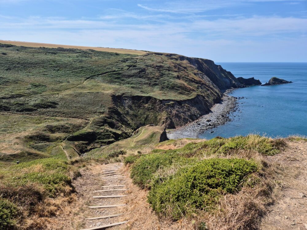
For such a difficult section, the first part of the walk was deceptively easy. There’s not much in the way of elevation change for the first mile, and then a gradual climb followed by a long stroll along the clifftops for the next three miles after that.


It was still pretty windy though, especially along the cliff edge where strong gusts would regularly appear out of nowhere. We’d planned to go and take a closer look at the waterfall at Speke’s Mill Mouth, but after several weeks of no rain there wasn’t much in the way of water, and the way the wind was catching our backpacks was enough to deter us from the climb down.
Not long after, the path briefly splits: you’ve got the choice of continuing along the cliff edge or ducking inland along the alternative valley route for a few hundred metres. Figuring that the valley might be a bit more sheltered (it was) and that we’d be getting plenty of clifftop walking the rest of the day (we did), we headed inland to mix things up.
It was a nice change of scene, with a grassy trail between rolling hills. There was no real view to speak of, but it was good to have somewhere out of the wind to stop for a snack. Pushing into the wind for hours gets tiring, as if the walk itself wasn’t hard enough today!
Rejoining the main path, the cliffs gently rose a little higher. That’s definitely the last time I’ll use the word gentle in today’s writeup, and with blue skies and bright sunshine making for epic coastal views, it’s probably not surprising that this was my favourite part of the day.
The path headed slightly inland at this point, joining the quiet road towards South Hole for about 500 yards. I mention this only because the spot where you leave the road again, through fields and back towards the coast, would be easy to miss if you weren’t paying attention. If you end up in the village, you’ve definitely gone too far!
The first of the infamous valleys showed up at Welcombe Mouth, which to be fair is a lovely spot. Especially if you’ve driven there. Many other more sensible people had done exactly that: the carpark was pretty full, and there were loads of people on the beach and in the water enjoying their Sunday as we approached.
The stream ran straight over some low rocks and onto the beach, forming small waterfalls that you can hear, if not really see, from the path alongside. After spotting a baby adder on the trail on the way down (our second adder sighting this week!), we found a spot sheltered from the wind and lay in the sun for ten minutes, mostly wishing we could do it for a lot longer.


Crossing the stream via a few stepping stones, we started up the other side of the valley, passing a group of teenagers in hiking gear alongside a harried-looking woman who looked like she’d spent her entire day trying to herd cats. I can’t imagine why.
Cats weren’t the only animal on our minds, however. If you grew up in the UK, chances are you’ll already know all about flying ant day. If, like me, you didn’t, it’ll sound like absolute madness.
Every summer, millions of winged ants are produced by their colonies, take to the air on a single day, and fly headlong into your eyeballs. I mean, fly around looking for a mate. The day (or more accurately, days) vary by where in the country you are and what the weather’s like, but trust me, there’s no mistaking it. And here, between Hartland Quay and Morwenstow, today was the day.
I can confirm that continually flicking ants off your clothing and face is the perfect distraction for painful feet. The entertainment was endless: whenever we finally found ourselves ant-free, we’d come to a kissing gate and find a few hundred more of our flappy little friends.
After climbing up from Welcome Mouth, we took a couple of minutes to have a quick look inside Ronald Duncan’s writing hut, right beside the path. Who is Ronald Duncan, you may ask, just like I did? Fortunately, there was a bunch of information inside the hut to answer that very question, letting me know that he was a well-known writer and poet who had a farm nearby. Well, there you go.
We crossed into Cornwall at the next valley (Marsland Water), saying goodbye to Devon for the next few weeks. It felt like we were making progress, although looking at the map, it also looked like we still had a hell of a long way to go.
The wind was finally starting to die off a little, which was great for making sure we didn’t get blown off the path, but also meant the flying ants became even more persistent. You win some, you lose some, I guess.
There were now just three valleys left before we got to Morwenstow, but one thing I’d noticed about the official guidebook is that it did love a good understatement. Today was no exception: while a phrase like “the ascents and descents continue” is technically correct, I’m not sure it fully conveyed what lay ahead. Let’s just say I was becoming even happier we’d decided to split this section in half!
After a break at the top, beside a wooden signpost that helpfully let us know it was 87 miles from there to Plymouth via the Tamara Coast to Coast path and a mere 300 miles along the route we’d be taking, it was time for the final push.


Barely two miles/3km from the flattish section along the Marsland Cliffs to the turnoff for Morwenstow, it still took us an hour and half to get there. I was not moving quickly.
There are several different footpaths that lead from the Coast Path up to the village: we took the one that joined up with the main road and past the impressive stone church. Not that it would have been hard to find said church: there was a large wedding about to start, and the bells were ringing out across the fields.
With the sun in full force now, wedding guests sweated through their suits as we sweated through our hiking gear, past the tearooms and on to the delightful Bush Inn, our home for the next 18 hours. It was packed full of people enjoying their Sunday roasts, but as hungry as we were, a shower and a nap held even more appeal.
Once I had the energy and motivation to move again, I took a proper look around the place and realised just how great it was. Small, cozy, and not a straight line in the place, just how a 13th-century pub should be. The evening was still warm and sunny, so we headed out to the beer garden for dinner, drinks, and general happiness about our decision to stay there.
A similar distance and difficulty lay in store for tomorrow’s walk, but that was definitely not tonight’s problem. Right now, it was all about a cold pint, a delicious burger, and no shoes. Perfect.
Get regular travel, hiking, and tech updates from me
News, reviews, guides, and more, from here and around the web
Planning
Started at: Stoke Barton Farm and Campsite (0.9 miles/1.4km off-trail)
Finished at: The Bush Inn (0.7 miles/1.1km off-trail)
We really liked this cozy, quirky 13th-century pub, and not only as a place to stay the night. My meal was some of the best pub food I had along the entire path, even on a Sunday evening when the place was very busy. The large terrace and beer garden was the ideal place to eat it as well, at least on a sunny summer evening.
There are only four rooms at the pub, but even on a weekend in August, we were still able to snag one the night before we arrived. We stayed in the double room, which was quite small but still had enough room for us and our backpacks.
The shower was hot, the bed was very comfortable, and despite being above the bar, noise from the pub wasn’t anywhere near loud enough to keep me awake. We paid £65 per person (£130 for the room).
If there are no rooms available or your budget doesn’t quite stretch that far, you can also camp in the pub’s garden area for free so long as you eat at the pub that night. There are no showers or other facilities for campers, but you can use the toilets in the pub and fill up water bottles at the bar.

Transport and Parking
Public transport options are very limited on this section, but they do (barely) exist. The 218 bus runs on weekdays, once a day quite early in the morning. It goes from Hartland (2.5 miles from the path at Hartland Quay) towards Bude, where you can then change at Poughill for the 217 which takes you back to Morwenstow.
The 219 runs from Hartland every couple of hours from mid-morning, but you have to go all the way around and back into Bude to catch the 217 back to Morwenstow. It’ll take three hours or more to do it. The 217 runs from Bude to Morwenstow and back three times a day.
There are other places to get off the path on this section, like South Hole and Welcombe Mouth, but you’ll need to leave a car there or arrange a taxi or other pickup. Bear in mind you may not always have phone service to call a taxi where you want it.
There’s parking at Hartland Quay (£3 all day), or a free parking lot in Hartland if you’re taking the bus to/from there. Morwenstow is small and its lanes mostly too narrow to park on, but there is a grass area near the tearooms where you can leave your vehicle for free.
Waymarking and Navigation
Navigation was straightforward on this section, with no real chance of going wrong along the coast. Just keep an eye out when you head inland: as I mentioned earlier, the turn-off from the road towards South Hole is easy to miss.
I used AllTrails as my main navigation app for the entire South West Coast Path, and it worked well throughout, including on this section. You can find the Hartland Quay to Bude route here: it’s free to use, although I pay a couple of pounds a month for a subscription so I can download maps to my phone in advance.
There are several public footpaths heading towards Morwenstow from the coast path: not all of them are labelled with the name of the village, but if you’ve got a map or are using AllTrails, it’s obvious which ones will get you there.
Phone Service
We had cell service with O2 in Stoke and Hartland Quay before setting out, but it came and mostly went for the rest of the day. If we were going to get it anywhere, it was up on the cliffs: there was very little chance of it down in the valleys.
As a backup, I’d also paid a few pounds for a data eSIM from Instabridge that let me swap between all three UK networks, EE, O2, and Vodafone/Three. It worked really well as a fallback option throughout my time on the Coast Path: whenever I needed data service but couldn’t get it on my usual SIM, I’d switch to the eSIM and choose one of the other networks.
If there was any signal to be had in the area at all, I’d pick it up.
Facilities
Stoke Barton campsite, where we stayed the night before, has a small but well-stocked store where you should be able to get enough snacks and fruit to see you through the day. If you stayed at the Hartland Quay Hotel overnight, breakfast is included and you can order a packed lunch as well.
You’ll need some kind of food, as there’s nowhere else on the path to get anything until you get to Morwenstow, which has tearooms and the pub.
Accommodation
There are no campgrounds between Hartland Quay and Morwenstow. Once you get there, as well as the semi-wild camping option out the back of the Bush Inn that I mentioned, there’s also Rectory Farm Wild Camping beside the tearooms. It has basic facilities (portaloos but no showers) and a limited season, from early July until the end of August.
The only other option I’ve found within a sensible distance of the path is a YHA with private rooms and bunkrooms at Elmscott, about 3/4 of a mile off the trail.
Have any thoughts or questions about today’s walk? Feel free to leave them in the comments.
If you’ve got value from this guide, or any of the SWCP guides I link to below, please consider supporting me with a small donation. It takes a long time to write 160,000 words!


All South West Coast Path Guides
Note that I tracked from accommodation to accommodation each day, starting my watch as I left wherever I’d stayed the previous night, and stopping it when I got to my campsite or hotel.
That includes every wrong turn and detour, extra distance to and from my accommodation, and whatever else I did each day that wasn’t on the official trail. As a result, my route maps, elevation chart, and measurements won’t exactly match yours or anyone else’s. Use them as a rough guide only!
Similarly, I can only write about the experiences I had while thru-hiking the South West Coast Path from early August until the end of September 2025. The day of the week, time of year, weather, and other factors affect everything from transport and opening hours to campsite availability and walking difficulty, so check the latest information before setting out.
