Around the Isle of Portland: South West Coast Path Day 46 Guide
Articles on this site contain affiliate links, meaning I may be compensated if you buy a product or service after clicking them. The full privacy & disclosure policy is here.

After a great night’s sleep in a quiet campsite, I was on the trail a bit earlier than usual: looking at the map and campsite locations, there was a definite chance it’d be a big day today. Little did I know I’d end up walking my longest distance of the Coast Path so far!
All of that lay (far) ahead of me this morning, though, as I set back out alongside the Fleet lagoon on a nice flat dirt path. 15 minutes later I arrived at the gate for Chickerell range, where ominous signs warned of the consequences of trying to enter when firing was taking place.
Thankfully today it wasn’t: the gate was open and the flag wasn’t flying, so in I went. Unlike Lulworth Cove a couple of days later, it’s not a big deal if the range is in use when you arrive, since you just loop around it to the left instead of the right. Distance and difficulty stay the same either way.
It only took ten minutes or so to walk around the edge of the range: there’s not a lot to see there, really, but the sun was shining brightly and the scene was as tranquil as it had been all morning.


After walking through the large Littlesea holiday park, I said hello to several dogs out walking their owners as we all climbed a small hill past the ranger station. There were great views back down the lagoon from the top of the rise, the endless shingle bank of Chesil Beach stretching for miles into the distance.
Those great views ended almost immediately afterward at a military training camp, surrounded by an ugly chain fence topped with razor wire. The path is forced inland along the fenceline for several hundred yards: not quite the bucolic coastal scene I’d been enjoying so far this morning.
After returning to the coast and a brief stroll along one of the many paths through a grassy field, I emerged beside Pirates Cove. The path around the edge of the lagoon here apparently gets covered at high tide, something I realised while standing in head-high reeds with water lapping around my feet.
The alternative is to go inland up the nearby path and lane to Westhill Road in Wyke Regis, on the edge of Weymouth. From here it was a bit of a slog down suburban streets, along Marlborough Ave and appropriately-named Walker Crescent to a narrow footpath that emerges on Portland Road. It’s all pretty well waymarked, just not particularly interesting.
I was now on the edge of the Isle of Portland, which the Coast Path circumnavigates for 13 miles before returning to the same spot. Portland is almost an island, but because it’s connected to the shingle of Chesil Beach, it’s guess it’s technically part of the mainland and that’s why the path goes around it.
It didn’t always: until 2003, the route stayed inland on what is now the South Dorset Ridgeway instead, bypassing Portland entirely.
The first stretch was uninspiring, over the bridge and down a concrete pavement beside speeding traffic for a couple of miles into the main town of Fortuneswell. What wasn’t at all uninspiring, though, was the excellent breakfast I had at Billy Winters, a canvas-covered restaurant and bar across the road just on the other side of the bridge.
The walking improved a bit once the main road headed off towards the other side of the island: the streets got quieter, at least, and I felt in less danger of choking to death on exhaust fumes. Where things really got better, though, was after turning off the high street towards the beach and along the promenade.


It was like I’d just walked through a teleporter. Traffic and noise disappeared entirely, and the view improved dramatically. It really gave a good impression of just how far Chesil beach stretches: 18 miles is a hell of a long way!
The path had been extremely flat all morning, but that was just about to change. From the promenade, the trail led up…and up…and up some more, all the way to the top of the hill. It’s definitely one of the steeper sections I’d walked in a while, quickly climbing 100m/300ft along a tarmac and then dirt path.
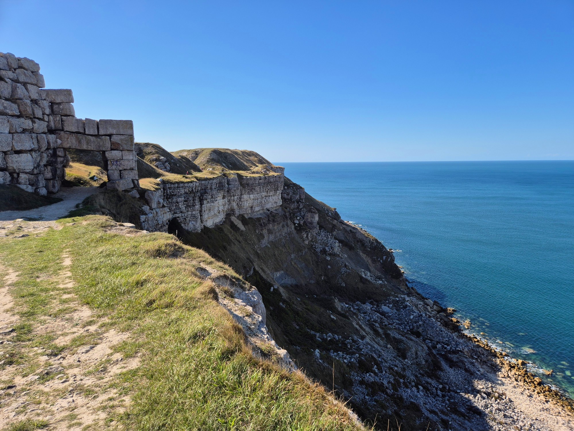
The views back over the town and bays on both sides of the island were nothing short of spectacular, and I had plenty of time to admire them as I caught my breath. Leaving behind a family who were loudly arguing about whether they should have driven up there instead, I continued on along the thankfully-flat ridge and into Tout Quarry.
This was the first of many diversions today: the cliffs around Portland are particularly prone to falling into the ocean, so the route changes even more often here than the rest of the Coast Path.
It’d be a worthwhile detour even if you didn’t have to take it, though: the quarry has been transformed into a sculpture park, and I spent a bit of time exploring its nooks and crannies alongside a school group doing the same.


From there the path carried on down the coast: this entire section from Tout Quarry along open clifftops all the way to the bottom of the island was my favourite part of the day. The weather couldn’t have been more perfect, the walking was an easy, gentle descent the whole way, and the crumbling cliffs and stony beaches made for postcard-worth views wherever I looked.
All told, it took about an hour to walk from the sculpture park down to the base of the island and the home of its most famous landmark, Portland Bill. As you’d perhaps expect, this 41m/135ft red-and-white striped lighthouse was visible from a long way off, as was the ever-increasing number of cars in the carpark.
I’d only met a handful of other people while walking down the west coast of the island, and that’s probably because they were all parked up here. I’d arrived right on lunchtime, as evidenced by the long queue for ice-creams and chips. Probably not both at the same time, although who’s to say?
I made do with a large drink and small packet of biscuits, which definitely didn’t hit the spot. Still, it was good to take a break and just people-watch for a while. Horse-watch as well, come to that: a line of riders quietly walking past did a good job of dispersing the crowds.


It’s a nice spot there beside the lighthouse, and I’d have gladly stayed even longer. The day was ticking by, though, and since I still wasn’t at all sure where I’d spend the night, I figured I should keep going. After a quick loop around the lighthouse and Trinity House obelisk right on the edge of the cliff, I turned to head back up the eastern side of Portland.
It immediately felt different to what I’d walked through this morning, starting with a rugged path beside a few chalets and through old quarry workings. The path was still nice and flat, just a bit harder underfoot and with a higher chance of rolling an ankle on loose rocks.
Gazing out over the bay, I noticed a long line of cliffs stretching east in the distance, and suddenly realised I was looking at almost the entire rest of the South West Coast Path. Three days from now I’d be rounding the end of that promontory, and walking along the beach at South Haven Point soon after. It seemed almost inconceivable that my walk was nearly over.
Pushing that from my mind, I continued on along what was now a wide gravelled path above Freshwater Bay. Just like on the way down, I’d hardly seen anybody else around after leaving Portland Bill, so it was a bit jarring to emerge onto the road and suddenly have cars zipping past again.


The route runs along the road (thankfully there’s a footpath), past a carpark and onward to a signpost pointing back down onto the cliffs. Another cliff fall nearby has forced a diversion here, though: now, you just continue on along the road into Wakeham instead.
The diversion goes down Church Ope Road to rejoin the Coast Path at Rufus Castle: there was no sign showing that when I was there, but hopefully there is by now.
Some kind soul has installed a couple of benches beside the castle ruins, which I gladly took advantage of to have a drink, eat a protein bar, and slap a bandaid on a rapidly-forming blister. Yes, apparently even after 6½ weeks of walking, I’m still not yet immune to blisters. Lucky old me.
After a quick chat with a couple of women who were walking the last few days of the Coast Path, I laced my shoes back up and carried on for another mile of easy walking. This part of the path was unusually flat and wide, thanks to being the route of an old railway line from Weymouth.
Just as I was getting used to it, the Coast Path took a sharp left and zig-zagged its way up to the top of the cliffs I’d been walking beside. It wasn’t quite as steep as the climb up from Fortuneswell this morning, but there wasn’t a lot in it.
The path emerged at the top beside a grim-looking prison, and I subconsciously sped up to get around it. From here, it was another mile to Portland Bill Camping at Fancys Farm, a campsite that I’d thought I might stay at tonight.
There were no tents set up in the field when I arrived, and when I found someone working nearby, they had to check if the campsite was still open. Apparently it was, but despite my excitement at seeing wallabies wandering around, it all felt just a bit too desolate, so I decided to carry on back to a site on the outskirts of Weymouth instead.
And just like that, my 16-mile day turned into a 20-mile one.
I was essentially on the edge of Fortuneswell by now, albeit high above it. After walking down some steps and through an underpass, I was greeted by epic views back over the marina and towards the mainland. I was also greeted by a remarkably steep gravel path back down past a hospital and into town: the guy I met coming up the other way didn’t look like he was having much fun.

My knees weren’t loving this downhill, but before I could wonder what kind of a deal the hospital could do me on a reconstruction, I found myself back on flat ground again beside the harbour and marina I’d seem from up on the ridge.
From there, it was another slog back along Portland Road, on the eastern side this time. The footpath isn’t paved on that side, so is quite a bit rougher underfoot. If your feet are as sore as mine were by this point, you might want to consider crossing the road.
I eventually made it back over the bridge, retracing my steps from early this morning to end up at Martleaves Farm. It’s a working farm with a couple of camping fields, and because it’s a bit of a Coast Path bottleneck due to that loop around Portland, there were more other walkers there today than I’d seen in weeks. And by that, I mean two.
I got chatting to one of them, Mike, and later joined him for a drink at the Wyke Smugglers. He was planning on walking the entire England Coast Path, a week or two at a time a couple of times a year. Unsurprisingly we had plenty to chat about.
Back at the campsite under a glorious sunset, I settled into my tent at the late hour of 7:30 p.m. and was asleep in minutes. I was, dear reader, absolutely knackered.
Get regular travel, hiking, and tech updates from me
News, reviews, guides, and more, from here and around the web
Planning
Started at: East Fleet Farm (on-trail)
Finished at: Martleaves Farm (on-trail)
This was a nice, fairly small campsite on a working farm in Wyke Regis, on the outskirts of Weymouth. The tent field is separate from the touring field, with enough room for 15-20 small tents. Given that only three people were staying there on this particular night, it wasn’t exactly cramped, and I was able to easily find a flat spot to pitch.
There’s not much in the way of shelter, though: it wasn’t an issue when I was there, but I’d imagine that in stronger winds you’d get blown around quite a bit. It’s also worth noting that there was a surprising amount of traffic noise at times overnight, presumably from Portland Road.
The toilet and shower facilities were clean and fairly modern, there was free Wi-Fi if you need it, and a laundry room for people who haven’t entirely given up on smelling good by this point. Not saying I know anybody like that.

Just a note that while the campsite is indeed right on the Coast Path, it’s three-quarters of a mile back from where the loop around the Isle of Portland starts and finishes. Don’t forget to factor that into your distance calculations for the day!
I paid £18 for the night, which is pretty normal for Dorset, if somewhat expensive for the Coast Path overall.
Transport and Parking
Public transport is good on this section, with a regular bus service from Weymouth that covers much of the Isle of Portland.
That’s the number 1 (Portland Link), which departs from beside the King’s Statue on the Weymouth esplanade, turning to head back south through town and down Portland Road to cross the bridge. From there, it runs through Fortuneswell, Easton, and Weston, before turning around at Southwell, a mile and a half from Portland Bill at the bottom of the island.
Because Portland isn’t very wide, you’re never far from a bus stop: it might just be a bit of a climb up or down to get to it!
If you’re coming from East Fleet, head up to Chickerell Road to catch the number 8 to the Weymouth bus garage and then swap to the Portland Link. Alternatively, walk along the Coast Path to Littlesea holiday park to catch the number 12 to Weymouth esplanade and do the same.
The Jurrassic Coaster (X53) also leaves from Chickerell Road: get off on Wyke Road and walk one street south to pick up the Portland Link from Buxton or Portland Roads.
The Portland Link runs every day including bank holidays, every 15 minutes for most of the day, with the first and last few services switching to half-hourly.
The number 8 runs half-hourly for most of the day Monday through Saturday, switching to hourly on Sundays and bank holidays. The number 12 operates hourly every day, with the first service from Littlesea holiday park departing at 9:30 a.m.
The X53 operates once an hour Monday through Saturday, once every two hours on Sundays and bank holidays.
Those useful bus services also make this section straightforward if you’re planning to leave a vehicle somewhere and do a bus/walk combo to come back to it later in the day.
There’s some on-street parking on Chickerell Road near the bus stops mentioned above, and you should also be able to find parking on side streets around Wyke Regis and near the route of the Portland Link as it goes through the southern part of Weymouth.
There are also plenty of paid carparks on and near the esplanade in the main part of Weymouth: the long-stay one beside the train station is probably your best bet.
On Portland, it’s not hard to find free street parking in any of the villages other than Fortuneswell: they all have good access to the Coast Path on both sides of the island. Tout Quarry has free parking close to the trail as well.
You might be able to find street parking in Fortuneswell as well, but it’s more difficult. Fortunately there are several carparks around there, however, including two small free ones right beside the Coast Path (marked as Masonic Car Park and Lord Clyde Car Park on Google Maps). There’s also free parking slightly further along on Brandy Row.
The carpark at Portland Bill is expensive for all-day parking and often quite busy, so I wouldn’t recommend that option.
Waymarking and Navigation
In general this should be one of the easier sections to navigate, since for most of the day you’re essentially walking down one side of an (almost) island and up the other. Even so there are a few tricky spots, thanks mainly to temporary or permanent diversions after cliff falls and subsidence.
As I mentioned above, I had to take an unexpected detour at Pirate Cove when the path around the edge of the cove was covered in water. There’s an official diversion almost immediately afterward, so it doesn’t really matter whether you go up Pirates Lane like I did or the footpath that follows it: you end up in on Westhill Road either way.
Most of the long-standing diversions on Portland are well-signposted, although it’d be easy enough to take a wrong turn in or around Tout Quarry. The more-recent diversions aren’t always marked as well: as I said above, there was no sign telling me where the detour into Wakeham returned to the coast. I just had to figure it out from a map screenshot on the SWCP route changes page. Lucky I had phone service at the time!
I used AllTrails as my main navigation app for the entire South West Coast Path, and other than brand-new detours like the one above, it worked well throughout: you can find the East Fleet to Weymouth section here, and the loop around Portland here. The app is free to use, although I pay a couple of pounds a month for a subscription so I can download maps to my phone in advance.
Phone Service
Service with O2 was a mixed bag today. There were a few dead areas between East Fleet and the outskirts of Weymouth, even as I got closer to town where I would have expected better signal. Likewise it came and went around Portland as well: while I usually had enough for a slow data connection or to send a text, that wasn’t always the case, especially towards the bottom of the island.
As a backup, I’d also paid a few pounds for a data eSIM from Instabridge that let me swap between all three UK networks, EE, O2, and Vodafone/Three. It worked really well as a fallback option all along the Coast Path: if I didn’t have coverage with my usual provider, I’d just switch to another. As long as there were any mobile phone towers in range, I’d have service.
Facilities
Other than the camp shop at East Fleet Farm, there’s nowhere directly on the trail to get food or drink until you get to Billy Winters, beside a parking lot just on the other side of the Portland bridge. I had a particularly good breakfast there, so it was worth the wait.
That said, if you can’t survive that long without food, there are several food places one or two streets off-trail on Portland Road before it crosses over the bridge. Most of them don’t open early enough to be useful for breakfast, but there’s a sandwich shop (Fresh Bites) that I very nearly went to that opens at 9 a.m.
That’s also where you’ll find Wyke Smugglers, the pub I went to for dinner when I got back.
Once you get into Fortuneswell there are many different options as you walk along the high street, mostly of the pub, restaurant, and fish and chip shop variety. There’s also Quiddles, a good little cafe on the beach slightly past where the Coast Path turns off to climb steeply up the hill.
There’s nothing directly on the trail after that until you get to the fairly uninspiring options at Portland Bill at the bottom of the island, but there’s a pub, takeaway, and Co-op supermarket a short distance inland in Weston.
It’s a similar story on the way back up the eastern side: there’s the Eight Kings pub a short distance inland from the trail in Southwell, but not much else except the Jailhouse Diner, a good cafe right beside the prison.
If you need to resupply, stop at the large Lidl on the way out of Fortuneswell, just before you get back onto Portland Road.
Accommodation
As well as Martleaves Farm where I stayed in Wyke Regis, there are a handful of campsites on Portland.
Hallett’s at Portland Bill, between Portland Bill and Southwell, is a simple affair with toilets but no showers, as is the other Hallet’s site between Weston and Wakeham. Sweet Hill Farm on the edge of Southwell has “nearly wild camping” as its tagline, but it does have composting toilets and (fairly expensive) hot-water showers.
Finally there’s Portland Bill Camping at Fancy’s Farm where I nearly stayed, on the trail above Castletown and Fortuneswell. The owners have recently decided to close the farm down, and although it’s going to be taken over in some capacity by new owners, there’s no mention of what that means for camping in the future.
If you’re not camping, you’ve got some good, affordable options both on Portland and in Weymouth.
On Portland, this B&B in Weston is an excellent choice and close to the trail: in fact, thanks to the detour at Church Ope Cove, you currently walk straight past it. In and around Fortuneswell at the top of the island, good places to stay include this self-contained apartment, this B&B, and this hotel.
Weymouth unsurprisingly has even more choice, but just be mindful of adding too much extra distance to what can already be a pretty long day. That said, there’s always the option of jumping on a bus back to the beachside area of Weymouth once you’ve finished walking around Portland (see the transport section above).
Good, inexpensive places to stay near the beach and Coast Path in Weymouth include The Sailor’s Return, The Ocean Guesthouse, the excellent Chapter One beside the beach, and slightly further along, the equally-impressive Redcliff B&B.
Have any thoughts or questions about today’s walk? Feel free to leave them in the comments.
If you’ve got value from this guide, or any of the SWCP guides I link to below, please consider supporting me with a small donation. It takes a long time to write 160,000 words!

All South West Coast Path Guides
Note that I tracked from accommodation to accommodation each day, starting my watch as I left wherever I’d stayed the previous night, and stopping it when I got to my campsite or hotel.
That includes every wrong turn and detour, extra distance to and from my accommodation, and whatever else I did each day that wasn’t on the official trail. As a result, my route maps, elevation chart, and measurements won’t exactly match yours or anyone else’s. Use them as a rough guide only!
Similarly, I can only write about the experiences I had while thru-hiking the South West Coast Path from early August until the end of September 2025. The day of the week, time of year, weather, and other factors affect everything from transport and opening hours to campsite availability and walking difficulty, so check the latest information before setting out.
