The Ultimate Guide to the Milford Track, New Zealand’s Greatest Walk
Articles on this site contain affiliate links, meaning I may be compensated if you buy a product or service after clicking them. The full privacy & disclosure policy is here.Chances are that if you’ve only heard of one walk in New Zealand, it’ll be the Milford Track.
The crown jewel of the country’s hiking network, it’s globally famous for its stunning landscapes and incredible views, but also for its changeable weather, challenging terrain, and great difficulty in securing a booking.
Known as “the finest walk in world”, I’d tried and failed to walk the track for years. Somehow, though, through a mix of perseverance, luck, and endless website crashes, three of us managed to score spots on the morning the booking window opened.
That’s why we found ourselves driving south on Christmas morning rather than spending it with family, ready to start walking the next day. Our dinner might have consisted of leftovers reheated in the hotel microwave instead of roast turkey, but surely it had to be worth it?
Spoiler: it was. I’ve walked several of New Zealand’s Great Walks over the years, and this was right up there with the best of them. To be honest, it’s one of the most spectacular multi-day hikes I’ve done anywhere in the world, and richly deserves its bucket-list status.
As with the other hikes I’ve tackled in New Zealand, I wanted to put together a guide for anyone else looking to tackle this particularly great Great Walk. I’ve broken it up into two main sections: planning and logistics, and the walk itself.
If you’re preparing to walk the Milford Track and want to know things like how to get to and from the trail, the difficulty level, what the huts are like, the stuff you need to take, and so on, read the first part.
If you prefer lots of photos, or want a route summary, daily distances, or blow-by-blow description of the walk, check out the second section. Or just read it all: it’s long, but I promise it’s worth it! 😊
We walked the track in summer, and this guide is written with that in mind. This is when the vast majority of people tackle the Milford, as it’s a very different and much harder experience outside the Great Walk season (late October to the end of April).
Unless you are a very experienced back-country hiker with all of the right equipment for extreme conditions (in which case you probably don’t need this guide!), I’d strongly recommend not attempting this track at other times of year.
Note that there are two ways to tackle the Milford: independently, or as a guided walk through a company called Ultimate Hikes. The latter costs thousands of dollars more, but you get to stay in fancier accommodation, take hot showers, have your meals cooked for you, and carry a much lighter pack.
I have no personal experience of the Ultimate Hikes experience, other than getting the occasional perfunctory nod from one of their customers as they passed. As a result, this guide is aimed fairly and squarely at those who DOC calls “freedom walkers”, and everyone else just calls “smelly hikers”.
Where Does It Start and Finish?

All of the Milford Track sits inside Fiordland National Park, a vast tract of protected land in the southwest of New Zealand’s South Island. This remote part of the country looks much the same as it did when the first humans arrived over 700 years ago, all waterfalls, mountains, and old-growth forest.
Unlike most of New Zealand’s other Great Walks, the Milford Track can only be walked in one direction, south to north. Every hiker starts at Glade Wharf, a jetty at the top end of Lake Te Anau, and finishes at Sandfly Point, near the small settlement in Milford Sound.
The nearest town to the start is Te Anau, which is the last place to stock up on food, equipment, and anything else you think you might need. From there, it’s a 25-minute drive to Te Anau Downs, then a roughly hour-long boat ride to Glade Wharf.
The boat ride at the other end is much shorter, taking just a few minutes to shuttle tired hikers across Deepwater Cove at the bottom of Milford Sound, from Sandfly Point to a marina on the other side.
Because the logistics of getting to and from the track are more complicated than many of the other multi-day hikes in the country, I talk more about them below.
How Long Is It?

Excluding any side trips or wandering around near the huts each night, the Milford Track runs for 53.5 kilometres, or 33.2 miles. If you’re silly motivated enough to walk all of the optional trails like I did, you’ll end up with a total somewhere north of 60km (37.3 miles).
Unusually for metric New Zealand, the distance markers are spaced a mile apart, with progress listed in both miles and kilometres. This is a nod to the historic origins of the trail, back when the imperial system was the order of the day.
For anyone who does a lot of multi-day hiking, 33-odd miles over four days probably doesn’t sound like much. Don’t be fooled, though: the weather, track conditions, and elevation changes mean you’ll be walking for several hours on all but the first day.
Weather

More than perhaps any other part of the country, Fiordland has extreme and unpredictable weather.
Locals love to tell you that it gets anywhere from seven to nine metres of rain a year (that’s 275-350 inches), not to mention the heavy snow that can fall on the McKinnon Pass even in summer.
While it’s possible that you’ll get a four-day stretch of perfect sunny weather, let’s just say it’s unlikely. The track sees about 200 rainy days per year: those waterfalls and rainforests have to get fed by something, right?
We were very lucky and only got wet on our last day: the rain started overnight and was still going as our bus drove out of Milford Sound twelve hours later. The rest of the time, it was sunny and warm, usually with blue skies and few clouds.
Other people aren’t so fortunate: I’ve seen reports of people walking on the track in waist-deep water thanks to flooding after heavy rain. It’s more of an issue in spring due to river levels already being high with snow melt, but it can happen any time.
Wind can also be a major issue, especially as you’re crossing the pass. There are stories of hikers having to literally crawl along the ground holding onto the tussock to avoid being blown off the mountain. Given how exposed it is, I have no trouble believing that.
Have I scared you off yet?
Fortunately, most people don’t get weather as bad as this, and we certainly didn’t. Most of the time, our biggest risk was sunburn, not hypothermia.
The forecasts for the area are as unreliable as the weather itself, but they’re still (slightly) better than nothing. Don’t worry too much about what they say more than 2-3 days in advance, though: they’re very likely to change by the time you start.
That said, if you’re a couple of days out and the forecasts suggest severe weather for most or all of the hike, especially the third day over McKinnon Pass, be aware of your limits and consider cancelling if you have to. The descent in particular is hard and potentially dangerous in bad weather, and major injuries (or worse) can and do happen.
How Hard Is It?

In good weather, the Milford Track is not a particularly difficult hike. Distances are reasonable, at least if you have some experience with multi-day walking, and most of the trail is relatively flat and well-maintained.
The first day is very short, and while the second is noticeably longer, there isn’t much change in elevation until the last couple of hours. Even then, it’s more of a persistent uphill than a gruelling climb, and won’t be too hard for anyone with reasonable fitness.
The third day is by far the most difficult, starting with a 500m climb up and over McKinnon Pass, followed by a knee-destroying 1000m descent down the other side. Track conditions are pretty rough as well, so slow and steady is very much the order of the day.
It’s only about 13km, excluding the side trip to Sutherland Falls, but trust me, it’ll feel like a lot more by the time you stumble into Dumpling Hut.
The final day is the longest, but it’s pretty much flat the whole way. There isn’t as much to see on this section and your pack should be a lot lighter by now, so chances are you’ll make good time the whole way.
DOC rates the difficulty of the track as “intermediate” during the Great Walk season. Overall, with the weather we had, it was barely even that. On a different week, of course, it could have been a very different story.
I’m sure I wouldn’t have been thinking how easy it was if I’d been battling my way over Mackinnon Pass in a howling gale and sideways rain, or wading thigh-deep through flooded sections of track on the last day!
A Quick Note on Gear

I’m not going to write up a full packing list here (you can find a useful one in the “What to Take” section on this DOC page), but rather just make a few observations about things that were more important on this Great Walk than others I’ve done.
Waterproofs
Given the amount of rain you’ll likely encounter, it makes sense to protect yourself and your backpack from it. For me, that meant a proper waterproof jacket, over-trousers, pack cover, and hiking shoes.
I’d used all of it in bad weather beforehand, so had faith that it would deal with the full day of rain that we inevitably got. My feet still got damp thanks to puddles and rain running into the top of my shoes, but everything else stayed dry. I’d maybe have taken a pair of gaiters if I owned them, but I don’t, so I didn’t.
Instead of waterproof shoes or boots, some people prefer to go the other way and wear lightweight trail runners that dry quickly instead. I don’t love that approach because of the lack of ankle support, but it’s an option.
If you don’t completely trust your pack cover to keep things dry, put everything in your pack inside a large bin liner as well.
Hiking Poles
I’ve been a convert to hiking poles ever since my knees start hating steep downhills a few years ago, but even if you don’t normally use them, I’d highly recommend taking a pair on the Milford Track.
Chances are you won’t use them on the first day, and can get by without them on the second and last day as well. Coming down McKinnon Pass, however, you’ll need all the help you can get to stay upright, especially if it’s raining and the rocks and tree roots are slippery.
My brother doesn’t usually use poles, but took some with him on the Milford anyway, and was extremely glad to have them on that third day. Conversely, that night I was chatting to a woman who does a lot of hiking: she’d chosen not to bring her poles with her, and greatly regretted that decision.
Long story short: take hiking poles. I’ve relied on Black Diamond Trail Sport poles for years, but you can also pick up generic versions from most outdoor stores in New Zealand. They won’t last a lifetime, but they’ll probably last until Sandfly Point.
Insect Repellant
I’ve spent over half my life in New Zealand, and nowhere else have I seen anywhere near as many sandflies as I did on the Milford Track. I know I mentioned it earlier, but I really can’t reinforce it enough: they will ruin your hike if you let them.
I bought some tropical-strength insect repellent with 80% DEET, which is a much higher concentration than I usually go for. Making sure I applied it to exposed skin every morning and (especially) evening, I only got a couple of bites. Others weren’t so lucky.
I used the Bushman brand, which is popular and easy to find in New Zealand, but most others with a high percentage of DEET should be fine as well. I don’t love the toxicity of DEET-based products, but I like getting hundreds of bug bites even less.
Anaesthetic/Antiseptic Cream
If the sandflies do manage to get through despite your best efforts, it’s worth having something to relieve the itching and swelling. I’ve found Soov to be best for this, since it has both an anaesthetic that numbs the area and an antiseptic to stop it from getting infected.
I’ve used this cream around the world for all sorts of bites and stings, and it really does work wonders. Again, it’s easily available in chemist shops in New Zealand.
How Long Does It Take?

Because you have to book each hut in order on the Milford Track, and can only stay in the one you’ve booked on any given night, there’s very little flexibility about how long the walk is going to take you. Barring absolutely appalling weather, you’ll be spending a total of four days and three nights on the trail.
If conditions are so bad that DOC considers it too dangerous to hike, the entire track will be closed: everyone stays where they are for another night, boats stop running, and nobody is able to start or finish their walk.
Closures like this are rare, but they do happen. Be prepared with an extra day’s food and, if possible, some flexibility in your onward schedule.
Phone Service and Charging

If you’re wondering where you’ll get cell service along the Milford Track, the answer is refreshingly simple: nowhere. Unsurprisingly, there’s no Wi-Fi either.
If you absolutely need to stay in touch with the outside world, look into an InReach or similar so you can send and receive text messages via satellite. Otherwise, put your phone in flight mode when you leave Te Anau Downs and enjoy the silence for four days.
Keeping your phone in flight mode has another advantage beyond the lack of distraction: it does wonders for battery life. I took a small power bank with me, expecting to need to use it somewhere around the halfway mark, but in the end it didn’t leave my backpack.
With flight mode and power saving enabled, and turning the phone off at night, I took 250+ photos and videos along the track and still had 40% battery left at the end.
There’s no way to charge anything in either Clinton or Dumpling Huts, but surprisingly, there were a few USB-A sockets in the wall at Mintaro Hut. I didn’t have the right cable with me to be able to use them, but others had no problem.
Where to Stay Before and After Your Hike

Te Anau is by far the most obvious place to stay overnight before starting the Milford Track. It’s the closest town to the start point, and because it’s the gateway to Fiordland National Park and all of the outdoor activities in the area, it’s well set up for hikers.
If you’ve forgotten anything or need last-minute supplies of any sort, chances are you’ll be able to find them here. There’s a decent amount of accommodation in the town: my pick is Amber Court Motel, which is where we stayed before and after the Kepler Track.
The rooms were large and comfortable, as were the beds, with parking directly outside the door. It’s only a couple of minutes’ walk from the lakefront and DOC visitor centre, and a 15-minute stroll (or two-minute drive) to the main strip of restaurants.
If you’re only after something cheap and cheerful, check out Te Anau Lakeview Holiday Park instead. It’s where we left the bags we weren’t hiking with (see below), and basic double or triple cabins with shared facilities aren’t much over NZ$100/night.
Because we were hiking the Milford over the peak holiday period, accommodation prices in Te Anau were sky-high that week. As a result, we ended up staying in Lumsden instead, a tiny town about an hour from Te Anau (90 minutes from Te Anau Downs).
There’s not much there beyond a couple of pubs, a takeaway shop, and a surprisingly-good place for coffee, none of which were open on Christmas Day anyway.
Most importantly for our needs, however, the Royal Mail Hotel was open, and had a cheap triple room with an ensuite and a large shared kitchen for about a third the price of anything in Te Anau! It wasn’t fancy, but it was clean and well looked after, and that’s all we needed.
Some people choose to stay in Queenstown the night before the hike: it’s about a 2.5 hour drive from Te Anau Downs. Of the places I’ve stayed there recently, I can recommend Coronation Lodge, a great little hotel opposite the park and gardens.
I wouldn’t suggest staying any further away than Queenstown, as it makes for an annoyingly-long drive to the start point. Likewise when you’re coming off the track: because you’ll be tired and likely won’t get back to Te Anau Downs until at least 4pm, look for somewhere nearby!
Luggage Storage
If you’ve got suitcases, backpacks, or other items that you’re not going to hike with but don’t want to or can’t leave in a vehicle, pop into the reception at Te Anau Lakeview Holiday Park before starting your walk.
For NZ$15, you can rent a good-sized storage locker for up to two weeks, and be given a padlock and key to secure it with. That’s what we did, fitting two suitcases and a small daypack in there, and it went without a hitch. We didn’t even lose our key while on the track!
Getting To and From the Trail

Given its remote location, getting to and from the Milford Track is a bit more difficult, and noticeably more expensive, than many of the country’s other Great Walks.
That’s because it requires two boat rides at a minimum, and likely one if not two bus rides as well. You’ll need to book these transfers in advance: a few companies offer them, in various different forms.
To quickly summarise, these packages consist of:
- Optional: a bus from Queenstown or Te Anau to Te Anau Downs
- a boat from Te Anau Downs to Glade Wharf
- a boat from Sandfly Point to Milford Sound settlement
- Optional: a bus from Milford Sound to the Divide, Te Anau Downs, Te Anau, or Queenstown
Some of the companies offer other options, including relocating your car from Te Anau Downs to Milford Sound while you hike. If you have a large group, that might be cheaper than paying for multiple people to take the bus back.
We used Fiordland Outdoors, one of the smaller, family-run operators, and were more than happy with the experience. One of the big advantages is that they run their water taxi from Sandfly Point continually from 12pm, so you’re not restricted to leaving at a set time.
We’d walked faster than expected on that final day, but were able to immediately jump on a boat at the end of the track. Some of the other people we’d been walking with had to wait over an hour for their boat to arrive, swatting idly at sandflies the whole time.
If you don’t have a car, you’ll need to start your trip with a bus ride from either Queenstown or Te Anau. If you have a vehicle, you can either leave it in Te Anau and take the same bus, or do what we did and park it in the DOC carpark at Te Anau Downs for the duration.
The small carpark is signposted from the main road, but it fills up quickly. There’s also a gravel road alongside that leads down to a boat launching area, and you can park anywhere along that as well. It’s at your own risk, so don’t leave valuables in the car if you can avoid it.
Boats leave Te Anau Downs for Glade Wharf from late morning to mid-afternoon, timed to coincide with the bus coming through from Queenstown and Te Anau. The times vary slightly by company, but we took the 2pm sailing and two boats left at the same time.
Our boat was much smaller than the other one: that meant it was faster getting to the other end, but also more affected by swells and wind. Take seasickness tablets if you think you might need them.
Our boat driver warned us that he’d had some big waves on his way back from the morning drop-off, but by the time we left, the wind had dropped and the lake was relatively flat. No sick bags required! The journey took just under an hour.

At the other end, the water taxi was waiting at the pier at Sandfly Point when I walked up. It took about five minutes to cross Deepwater Basin to the marina, and a shuttle bus arrived soon after to drive me the short distance up to the cafe and information centre.
The bus is meant for moving passengers on and off scenic flights from the nearby airstrip, but is usually available for hikers whenever there isn’t a plane around. If you’re unlucky enough to arrive at the wrong time and need to walk, it takes about 15-20 minutes.
The experience of wandering into a crowded, noisy cafe after four days in nature was more than a little jarring, but the hot pie and drink made up for it. Almost.
Our bus left from outside the cafe at 2:30pm, and took about two hours to get back to the carpark in Te Anau Downs via the Divide. That’s where we got out, threw our stuff in the back of the car, and headed for a well-deserved meal of fish and chips to celebrate the end of the walk.
Our transfers cost a bit over NZ$200 per person, which included the two boat trips and the bus ride back to Te Anau Downs. Given the uncertainties around weather, it’s probably worth paying the extra NZ$10 for cancellation insurance as well.
Bookings

Hut bookings are required for the Milford Track during the Great Walk season, which runs from the end of October to late April.
As I’m sure you’ve found out already if you’ve done any research on the Milford Track, they’re extremely hard to come by. There are only forty beds in each hut, and since you can’t camp, that’s the hard limit for the number of people who can start the track each day.
Bookings sell out for the entire Great Walk season as soon as they’re released. That’s generally in mid-late May, with the exact date advertised on the DOC site a few weeks beforehand. We were on the site the second it went live: it immediately crashed for ten minutes, then came back reporting no available beds at all.
We persevered, however, and eventually got lucky: over the next hour, one, then two, then three bookings popped up for a start on Boxing Day. It felt like winning the lottery would have been easier.
Of course, people’s plans change, so it’s worth checking back every so often just in case. A couple walking the track the same time as me said they’d only booked a month earlier; they just happened to be on the site at the right time to grab a cancelled booking.
Unless you’re a masochist who wants to run the entire length of the track in a day (I was passed by a few), you can only walk in one direction, over the course of four days, staying in each of the three huts in turn along the way.
There’s zero flexibility about this, which at least makes the process easier if there are any beds available: you just pick your start date and the rest of the booking auto-populates.
Hut bookings on the Milford Track are the most expensive of the Great Walks, which felt like a bit of a rip-off until I got there and realised just how remote some of these huts are, and how much work it is to build and maintain them.
The new Mintaro Hut, for instance, apparently cost $3.5 million when it was built a few years ago, with everything needing to be helicoptered into place. That’s just the day one cost: everything that’s happened since then is extra.
Like most of the Great Walks, international visitors pay more than New Zealand citizens and residents during the October-April season. If you’re paying the Kiwi rate, take proof of your eligibility for it: a copy of your NZ passport or driving license will suffice.
Prices per night in 2025/2026 are as follows:
New Zealand citizens and residents
- Adults: NZ$106
- Youth: NZ$53
International visitors
- Adults: NZ$152
- Youth: NZ$76
DOC strongly recommends against walking the Milford Track outside the Great Walk season, both because it’s much more dangerous but also because the huts aren’t staffed and services and facilities are greatly reduced.
If you decide to do it anyway, though, the per-night prices drop dramatically and bookings aren’t required. Everyone pays NZ$30(adult) or NZ$15(youth) per night, on a first-come, first-served basis.
Day Walks on the Milford Track

If you weren’t able to secure hut bookings, it’s still possible to experience a bit of the Milford Track magic on a day hike.
The boat companies that provide transport to multi-day hikers also offer day walks, dropping you off at either end of the trail in the morning and picking you up again in the afternoon.
From Glade Wharf, the suggestion is to walk to Clinton Hut and back in 3-4 hours, while from Sandfly Point, you can make it to Giants Gate Falls and back in the same amount of time.
Either way, you’ll walk roughly 10km return on what are by far the easiest sections of the track. They’re also probably the least-interesting sections, especially the one between Sandfly Point and Giants Gate Falls, but I guess those two things often go hand in hand.
Personally, if you’re looking to spend a few hours on a Great Walk in the area, I’d suggest looking at the Kepler instead. I’ve listed a few options in my Kepler Track guide, all of which cost a lot less (or are free) and are, in my opinion, more impressive than what you can see at either end of the Milford.
If you do decide you’d rather do a day walk on the Milford Track anyway, expect to pay around $75pp from Milford Sound, and $135pp from Te Anau Downs.
Food and Drink

If you’re wondering what you’ll be eating on the Milford Track, the answer is simple: whatever’s in your backpack. There’s nowhere to buy food, drinks, or anything else once you’ve left Te Anau, so make sure you’ve got more than enough to see you through.
I ate a variety of freeze-dried meals for dinners, and had a bag full of protein bars, peanuts, chocolate, crackers, and salami for lunch and snacks. Breakfast was generally just a couple of handfuls of nuts and chocolate, plus a coffee from my trusty AeroPress Go that I reviewed here.
My hiking companions put in a bit more effort than me, making pesto pasta each night, but sticking with a similar diet for breakfasts and lunches. Our meals were tasty and gave us enough calories each day, but we were no match for the people who bought in a loaf of sourdough bread, or those carrying a carton of eggs with them!
We had no problems refilling our water bottles at the huts, and some of the shelters also had water available. Taps are connected to large water tanks, either directly at the shelters or piped into the kitchens of the huts.
Given the amount of rain that falls here, it’s extremely unlikely that they’ll ever run dry.

There are signs at Clinton and Dumpling Hut advising you to boil or treat your water before consuming it, as well as at all of the shelters with a water tank. Many people don’t bother, including me, but my stomach is not your stomach. If you’re concerned, boil it for at least a minute or take a water filter with you.
Mintaro Hut is one of the very few DOC huts that filters all of the water that runs into the sinks, so even if you’re treating your water elsewhere on the track, you don’t need to do it there.
You can also choose to refill your bottle from streams and rivers at lower altitudes; there aren’t any above the treeline as you cross McKinnon Pass, but there is a rainwater tank at the shelter. Again, you may choose to filter or boil it first if you decide to do this.
The water at Dumpling Hut had a definitely yellowish tinge due to tannins, but was still fine to drink, at least for me.
Wildlife

In terms of animals that can kill you, New Zealand is a paradise for hikers: there are no deadly spiders, no snakes, no real predators, and even the mosquitos and ticks don’t carry any nasty diseases.
As far as animals are concerned, the only two that are likely to give you any concern on the Milford Track are sandflies and keas, New Zealand’s beautiful alpine parrot. I love these smart, inquisitive birds, but their curiosity can be a real issue for hikers.
They’ll happily peck at unattended backpacks and boots, especially if there’s anything shiny to attract their attention. They’ve even been known to pull the laces out of pairs of shoes and fly away with them, leaving very confused hikers behind them!
Just keep an eye out for them, and don’t leave things that you value outdoors and unattended, especially if you can’t see them from where you are. Note that keas are absolutely protected by law: don’t try to touch or hurt them in any way.
There are loads of other birds that live in the area as well: I was extremely lucky to see a rare whio (blue duck) on a river bank on the second day, and the even rarer pāteke (brown teal) was reintroduced to the Arthur Valley a few years ago.
Other hikers came across kākā (another great New Zealand parrot) as they walked, and it’s apparently not uncommon to hear brown kiwi calling in the forest at night.

You’re also likely to see a few South Island robins: these cute little birds seem to have no fear of humans, and would regularly come and hang out within a few inches of us when we stopped on the side of the track.
I love all of New Zealand’s native birds, and seeing so many of them during the walk was one of the biggest highlights. I was, however, much less excited by the sandflies.
These tiny biting insects are the biggest issue you’re likely to face on the Milford: they are everywhere along the track except at the highest points, but you’ll find especially large swarms of them wherever there plenty of humans for them to feed on. Huts and shelters, in other words.
Heavy rain and wind do keep them away, so at least be thankful for that if you’re battling through terrible weather, but otherwise you’re going to want insect repellent with a high concentration of DEET unless you like the idea of scratching dozens of bites for days.
They’re present throughout the day, but especially around dusk. When you’re done hiking, put on long sleeves, pants (trousers), socks and shoes, keep moving around if you’re outside, and apply insect repellent to any exposed skin.
Dark colours are better than light ones, and there’s some evidence to suggest that high levels of B vitamins make you less attractive to them. No harm in grabbing a tube of Berocca from the supermarket before you set out, I guess.
Huts

Turning to the huts themselves, all three have similar facilities, although Mintaro Hut is noticeably newer and fancier than the other two.
During the Great Walk season, you’ll get gas cookers, sinks with a water supply, dishwashing liquid and cloths, solar-powered lighting, a wood fire, and even flush toilets.
There’s an indoor common area with tables and chairs, and 2-4 bedrooms with bunk beds and mattresses. Assuming the weather and sandflies aren’t enough to put you off, there’s some sort of outdoor seating area at each hut as well.
There are no showers, but you can swim in the beautiful (and cold) lakes and rivers if you like. You’ll need to take your own food, sleeping bag, cooking and eating equipment, and anything else you might need.
At other times of year, facilities are significantly reduced: there are pit toilets instead of flush, no gas or other cooking fuel is provided, water is turned off to the huts, and no rangers are present. During winter and spring, many bridges are also removed on the track due to avalanche risk.
Clinton Hut

Only 5km from the start point, Clinton Hut sits in an open area in the valley of the same name, at 225m above sea level. It’s an older-style hut, built around a large wooden deck with buildings on three sides.
The two buildings in the photo are 20-person bunkrooms, and the kitchen/dining/common room is off to the right. Uniquely, there are also two large plastic hula hoops on the wall, which I may or may not have used. Gotta find some way to pass the time!
There are only a few picnic tables dotted around on the deck, not enough for everyone to use at once. That seemed mildly surprising, at least for the first ten seconds that I sat at one. After that, the sandflies found me and I beat a hasty retreat back inside.
The toilets are in a different building, slightly further back down the access track. Having non-smelly, flush toilets in the middle of nowhere feels like an absolute luxury, and I have nothing bad to say about them.
While each bunkroom is split in half by a wooden partition down the middle, it doesn’t reach all the way to the roof and does nothing to block out noise. There were, as usual on hikes like this, no shortage of snorers to test that theory with.
Tip: it’s only a few minutes back down the track to a gravel beach on the Clinton River, which is the perfect place to go for a swim if you’re so inclined. Take a towel and plenty of bug spray. There’s also a small grotto nearby where you can see glow worms at night: the ranger will give directions.
Mintaro Hut

Mintaro Hut used to be the most run-down of all the accommodation on the Milford Track, but a few years ago DOC decided that there was an unacceptable risk of the hut being wiped out by an avalanche at some point.
A new location was found a couple of kilometres away, and several million dollars later a beautiful new hut stood in its place. Spacious and modern, with high ceilings and light wood, it still feels new when you step inside.
Alongside the usual facilities that the other huts have, there’s a fancy fire alarm system, filtered water supply, those USB ports in the wall that I mentioned earlier, and a wrap-around deck that catches whatever sun there is all day.
Even the bunkrooms are noticeably better than those in the other huts, with 10-12 bunks per room, thicker mattresses, and cubbyholes to store your pack. Toilets are again set a short distance away from the rest of the buildings, along a covered walkway.
At 620m, the hut sadly isn’t high enough to avoid the sandflies, but there did seem to be somewhat fewer of them than usual. Maybe word just hasn’t got around the sandfly community yet that the hut has changed location.
A community of keas lives in the area, and regularly pay the hut a visit. That’s super-endearing in the evening when they’re playing peek-a-boo with hikers, and somewhat less endearing at 5:30am when they’re screaming at each other outside the bunkroom window.
The warden said there are seven keas that she knows of that visit regularly, and I saw five of them at various times. There’s an indoor area for storing boots and hiking poles: be sure to use it if you’d like them to still be intact the following morning.
Tip: it’s possible to walk from the hut up to the McKinnon Memorial at the top of the pass and back again in about 2.5 hours. If the weather is good when you arrive but the forecast for the following day isn’t, it’s worth the climb if you’ve got the energy. Otherwise, you’ll just have to take your chances the next morning!
Dumpling Hut

After the Club Med-like conditions at Mintaro, it was a thump back down to reality when we arrived at Dumpling Hut. Still, I doubt anyone was sad to see it: it’s a long, hard day to get there no matter the weather!
The bedrooms are much more typical of DOC huts: simple wooden bunks in a line along each wall. There are four different rooms, at least, so you can try to cherry-pick your bed to avoid snorers. You’ll have a pretty good idea of who they are by now.
This is also the only hut where the common room is separated from the bunkrooms by about 20 metres of open space, something that became very apparent when the rain set in!
Other than that, though, there was nothing to complain about. Everything from the toilets to the bunks and gas cookers looked and felt their age, but they were all well-maintained and worked fine.
At an altitude of just 125m and with plenty of rain around, the sandflies were particularly obnoxious whenever we stepped outside. I was almost wishing for strong winds just to blow the damn things away, but sadly they didn’t make an appearance that day.
Tip: there’s a large empty space at the back of the common area, with a few spare mattresses up against the wall. If you snore, or are trying to avoid those who do, it wouldn’t be a bad place to sleep.
Special Shoutout: McKinnon Pass Shelter

I don’t usually bother commenting on the shelters that you find along the Great Walks: they’re always welcome, but usually consist of little more than a roof and a few picnic tables to eat your lunch on.
McKinnon Pass Shelter, however, holds a special place in my heart, and probably that of everyone else who walks the Milford Track.
Even with near-perfect weather like we had, it’s a decent climb up from Mintaro Hut to the top of the pass and along the ridgeline to the shelter. I can only imagine how welcome it must be to those who’ve braved heavy rain, gale-force winds, or snow to get there.
It’s weirdly separated into two rooms, one for ordinary old hikers like me, and one for the guided walkers. Maybe we smell too bad by that point to mix with the private customers?
There’s a rainwater tank outside, and a toilet securely bolted down to the rocks nearby. The warden at Mintaro Hut had suggested that this is the toilet with the best view in New Zealand, and on a day like the one we had, I wasn’t about to disagree.

This is apparently the fifth shelter to sit on this site, the previous four having being blown literally right off the mountain at various points in the last century or so. Just in case you needed further confirmation that the weather there can get quite interesting.
The room is fully enclosed, high enough and windy enough to not have any sandflies around, and has epic views in both directions, but those aren’t even the best bit.
No, that’d be the gas cooker set up on a bench inside. There’s something particularly great about being able to make a hot coffee inside a hiking shelter on a remote pass in the middle of nowhere. And so I did.
You’re not allowed to stay overnight in the shelter unless it’s a dire emergency, which is a bit of a shame: it’d be a hell of a view to wake up to!
Get regular travel, hiking, and tech updates from me
News, reviews, guides, and more, from here and around the web
Milford Track: Day by Day
Below is a daily description of the experience my brother, his partner, and I had on the Milford Track in early summer. We had generally good weather, an amazing experience, and no injuries or other problems to speak of.
The times I’ve listed below were how long it took us to walk each section, not including any food or rest breaks. Other than the third day, we generally walked faster than what was estimated in the DOC brochure, but more wind and rain would have slowed us down for sure.
Day 1: Te Anau Downs to Clinton Hut

After an uneventful boat ride up to the top of Lake Te Anau, we disembarked with a few other hikers at Glade Wharf right on 3 p.m., and posed for photos around the sign at the start of the track.
There’d been a few spits of rain at the other end of the lake, but we were bathed in sunshine as we set off on a flat, wide path through the forest.
Stopping only to admire the huge flat mushrooms growing out of the side of several of the taller trees, we soon found ourselves walking through an open meadow towards Glade House, an old wooden lodge that dates back to 1895.
Despite only being a kilometre from the start, this is where the customers on the guided walk end their hike for the day, with hot showers and a multi-course meal to help deal with all that exertion.
We carried on, however, crossing the long suspension bridge over the Clinton River that runs alongside. The track followed the river for the rest of the day, weaving its way through tall beech forest and with lots of opportunity to get down to the water (and the sandflies) as we walked.

The first of what turned out to be many large mushrooms on this section of track Suspension bridge over the Clinton River near Glade House I don’t know if I’ve ever seen a river quite this clear before


The daily distances on the Milford Track are a bit odd, with such a short first day and then three longer ones. There’s basically no elevation change anywhere along this first section of track either, so with weather like this, the walking couldn’t have been easier.
Sure enough, not much over an hour later, we wandered into Clinton Hut. After choosing our bunks and chatting to other hikers, we didn’t have long to wait for a nature walk with Tizzie, the DOC ranger.
There’s a helipad in an open area near the huts, used for evacuations, deliveries, and apparently, to hold 40 people while they learn about the flora and fauna of the surrounding area.
Afterwards, I made some dinner, practiced my non-existent hula hoop skills on the deck, and sat outside with my Kindle for a few seconds before retreating inside the hut to keep reading without the company of sandflies for the rest of the evening.
This far south, it doesn’t get dark until around 10 p.m. at this time of year, but as usual on these sorts of walks, everyone seemed to be in bed long before that. The snoring had already started by the time I hauled myself up into my bunk. No surprises there either.
Side trip: Wetland Walk

About ten minutes before the turn-off to Clinton Hut is a small sign pointing off to the left for the Wetland Walk.
It’s a loop track, so you can leave your pack at the junction if you like, but it’s only a short walk in any case. You don’t need more than ten minutes to stroll along the wooden boardwalk and return to the main track.
It might be short, but it’s well worth the effort: this wetland, covered in sphagnum moss, is the first real open area on the track. It felt very different to the thick forest nearby, and with the sun out and plenty of blue sky, we had spectacular views up the Clinton Valley as well.
Day 2: Clinton Hut to Mintaro Hut

With the sun rising around 6 a.m. and half the people in the hut rising five minutes later, there was no chance of a sleep-in. A couple of protein bars, a handful of peanuts, and one strong cup of coffee later, I was soon back on the trail.
The forecast had been surprisingly good, and it turned out to be accurate: other than a few wispy white clouds that soon burned off, we had nothing but sunshine and blue skies the whole time. Between the fantastic weather and epic landscapes, this ended up being my favourite day of the entire walk.
The Milford Track is basically a tale of two valleys, Clinton and Arthur: other than the Mackinnon Pass that joins them, you walk along one or the other for all four days. Today was all about the former, as we kept following the river all the way up the valley.

The river was shallow, placid, and incredibly clear: we could easily spot trout as they swam lazily along the opposite bank. With tree-lined hills on either side and snow-capped mountains in the distance, it felt like we were walking through a Tourism New Zealand brochure.
After an hour or so, we reached the point where the Clinton River splits in two: the track follows the west branch. Up until that point we’d mostly been walking through forest, albeit with lots of gaps to admire the views. From here, though, things opened up dramatically.
This is the so-called “prairie” section, and it’s not hard to see why. The valley floor gets much wider, with smaller bushes and grasses instead of tall trees. It’s easier to get a sense of just how tall the surrounding mountains are: if you enjoy feeling like an ant, this is the place to do it.
It’s also where we got our first glimpse of McKinnon Pass in the distance, a lower ridgeline amongst the nearby giants. As we got closer, we could even see the shelter glinting in the sun at the top: it still looked a long way off!
Waterfalls tumbled down the cliffs on both sides of the valley; they were quite small when we passed, but get much more powerful in heavy rain. One of the larger ones is Hirare Falls, clearly visible in the distance on the other side of the river.

A few minutes down the track is Hirare Shelter, which is officially only for the use of those guided walkers. I say officially because if you’re there before they all show up late morning, there’s nothing stopping you from sitting on the riverbank alongside if the weather is nice, or under the outdoor shelter if it isn’t.
And so that’s what we did. Beautiful, calm, and very quiet, with the only sounds being the rustling of nearby wekas and our contented chewing, we lazed beside the river for much longer than was perhaps strictly necessary to eat our snacks and get moving again. On a day like today, why rush?
After taking in two short side trips (below), we hit Prairie Shelter right around lunchtime. It’s not much more than a roof with a few picnic tables, but it’s in a lovely spot and hey, it was time for more food anyway. When you’re burning 4000+ calories a day, any excuse to eat is a good one.
One of the great things about the Milford Track is that its lack of flexibility, combined with no phone service for distractions, means you get to know your fellow hikers a lot better than on other Great Walks.
With the same 40 people in the huts for three nights, and long evenings of interesting conversation with people from all over the world, a bunch of strangers at the beginning felt like good friends by the end.

As we chatted to some of them in the shelter, with wekas skittering around looking for a handout and the sun continuing to shine from a cloudless sky, I reflected on just how lucky we were. Not just to have such great weather or to have got hut bookings, but that places like this still exist in the world at all.
The prairie section ended shortly after leaving the shelter and we returned to the forest for half an hour. The trail started to get steeper at this point: we’d been climbing gradually upward all day, but this was the first time we really noticed it.
Passing Bus Stop Shelter (clue’s in the name), we crossed the large, rocky expanse of Marlenes Creek. This boulder field can be impassable during heavy rain, hence the shelter right alongside, but it was dry as a bone as we picked our way across. The trail is marked only by orange poles here, but it’s easy to follow.
Crossing the creek via a pair of bridges, it felt like we should be nearly done for the day, but there was still around 5km to go. Starting to tire, and with a steady climb and plenty of rocks and tree roots to contend with, this was the definitely the hardest part of the day.


Still, it passed quickly enough, with a minimum of grumbling and a maximum of stunning views and tumbling waterfalls. Passing pretty Mintaro Lake (technically a side trip, but so close to the main track that I’m not separating it out), we wearily climbed the steps up into Mintaro Hut just after 3pm.
As I mentioned earlier, this newly-built hut is by far the best on the track, a fact not lost on us as we sat out on the balcony drinking coffee in the sunshine. Gazing up at McKinnon Pass, we (very) briefly considered climbing up to the memorial while the weather was so good, but our aching legs had other ideas.
Instead, the crazier members of the group stripped off and went to throw themselves into the ice-cold water a couple of minutes back down the path. These beautiful clear pools provide a chance to wash the dirt off to anyone brave enough to jump in, and free entertainment in the form of loud screaming to everyone else.
Soon after dinner, the resident keas came out to play. I’ve never seen a parrot playing peek-a-boo with a human before, but one of them definitely was that night. As if I didn’t love these birds enough already.
Something I loved less was the weather forecast for the next day. Overcast all day, with rain appearing at some point in the afternoon, and a good chance of fog on the way up McKinnon Pass.
It didn’t seem dangerous, since we’d probably be over the pass by the time the worst of it showed up, but it did sound like those famous views from the top would be hidden behind a thick layer of cloud.
We all headed off to bed and pondered what the morning might bring.
Side trips: Hidden Lake, Prairie Lake

There are a couple of optional side trips as you cross the prairie section: a ten-minute loop track to Hidden Lake, and an even shorter out-and-back track to Prairie Lake. Neither of them are going to blow your mind after everything else you’ve seen that day, but they’re still worth the small time investment.
Hidden Lake is indeed tucked away out of sight of the main track, fed by a small waterfall that flows down the cliff behind it. The trail goes past two or three other small ponds as well, which apparently weren’t deemed impressive enough to get their own names.


On a nice day, this would be a good place to stop for lunch or a snack, as long as you don’t mind sharing it with sandflies and wekas.
Prairie Lake is only a couple of minutes off the main track, and is probably the prettier of the two side trails. You’re closer to the waterfall that feeds it, to start with, and the view back down the valley on a clear day is stunning.
Day 3: Mintaro Hut to Dumpling Hut

An early-morning alarm call from the keas playing outside our bunkroom window meant we were again up by 6 a.m. The lack of sleep wasn’t a big surprise, but the clear skies overhead very much were.
So far, at least, there was no sign of the fog that apparently carpets the valley most mornings, or the heavy cloud that had been expected to roll in overnight. I don’t think I’ve ever eaten breakfast or packed a backpack faster in my life. This day was meant to have by far the most dramatic views, and I didn’t want to miss them!
I’d read differing reports of the 500m climb from the hut to the top of McKinnon Pass: some people said it was a killer, others suggested it was pretty straightforward, at least in good weather.
I’m much better going up than down these days, and while the roughly 90-minute stomp up the endless switchbacks to the memorial was a decent cardio workout, it wasn’t ridiculously steep in the end.
Wait…clear skies?! Climbing up to McKinnon Pass Above the treeline on McKinnon Pass


Much of the rocky track was shaded by trees, at least until it got high enough to leave the bushline, and the surroundings were incredible. Nearby mountains lit up in turn as the sun rose higher in the sky, and the only sounds were from the birds and my laboured breathing.
Clouds starting to drift in over the ridge as I neared the top, though, so I lifted my pace in the hope that I’d get there before the views disappeared completely.
In the end, while a thick grey blanket stretched to the western horizon, it was high enough not to matter. There was still plenty of blue sky everywhere else, so given what the forecast had said, I’m going to call that a massive win!
The McKinnon Pass is named after Quintin McKinnon, who discovered it in 1898 and in the process opened up the land-based route to Milford Sound that ultimately became the track we were all walking along.
He drowned in Lake Te Anau a few years later, and this memorial was later painstakingly erected at the top of the pass, carried up rock by rock and carved out by a stonemason in often-appalling conditions.
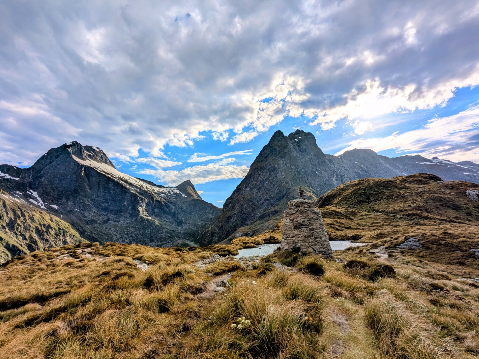
McKinnon Memorial, near the top of the pass Looking back towards the McKinnon memorial Looking down towards the McKinnon memorial


Mildly-interesting fact: you’ll notice that the memorial and DOC signs spell the explorer’s surname as “Mackinnon”. That was apparently a mistake, albeit one that lasted over 100 years, and the name of the pass was officially changed to “McKinnon” in 2022.
Whatever the memorial is now called, I was the only person there at the time, so I lingered for a while taking photos in every direction before starting the 20-minute stroll along the ridgeline to the shelter.
And a stroll it was: the breeze was cold enough to have me reaching for another layer, but I really couldn’t have asked for better weather. The clouds broke up again as I got to the shelter, and the views went from great to spectacular.
That was all the incentive I needed to make myself a coffee, prop myself up on a nearby rock, and chill out in the sunshine for an hour as I waited for the others to arrive.
Looking down towards McKinnon Pass shelter Can’t complain about the view! Making coffee in McKinnon Pass shelter View down the Clinton valley from McKinnon Pass


I got chatting to a couple who’d walked the length of New Zealand on the Te Araroa trail the previous year, a multi-month commitment that makes the Milford look like a stroll in the park. Unsurprisingly, they weren’t finding it too difficult!
Eventually, though, it was time for the 1000m downhill that I’d been mildly dreading since we first booked this walk. Even in dry conditions, the track was rough and steep, with loose rocks and tree roots everywhere, and slippery in places thanks to small streams.
I’d been using my hiking poles on the way up the pass, but this was where I was very glad I’d bought them. Not only did they reduce the impact on my knees, but they gave me a lot more stability on wet and uneven rocks. Even so, there was no shortage of slipping and sliding.
Looking down to the top of the Arthur Valley The main track had only been open a couple of weeks when we walked at the end of December Finally the path gets flatter, if not any less rocky


The track hugs the side of Mt Balloon as it descends, before dropping further into a rocky valley that follows Roaring Burn, a river that easily lives up to its name. Like much of the trail, this is complex avalanche territory: there’s an emergency track that bypasses the most avalanche-prone section, at the cost of an even rougher, steeper descent.
Due to heavy snowfall the previous winter, DOC had only opened the main track a couple of weeks earlier: before that, everyone had been on the emergency route.
Wildflowers were blooming all the way down the mountain, which gave me something to look at whenever I stopped for a breather. Finally crossing to the other side of the valley and returning into the trees, I came across pretty Maureen Falls, before descending some steep, slippery wooden stairs down towards Andersons Cascade Shelter.

After stopping for a quick sandfly snack break, it was time for the last steep section of the day, down to Quintin Shelter. This felt like it took forever, but that’s mainly because I was getting pretty tired by this point and was ready for a proper break.
That break came at the shelter, which sits alongside Quintin Lodge where the guided hikers spend the night. This means the shelter has power, and free hot water, coffee and tea kindly provided by Ultimate Hikes, the company that runs those private trips.
It’s only a little over 5km from Mackinnon Pass Shelter to Quintin Shelter, but it took me at least three hours to pick my way down, not counting the stop for lunch. Slow going indeed, but thankfully no injuries!
This shelter is about an hour’s walk from Dumpling Hut, but more importantly, it’s also the start of the side track to Sutherland Falls (below). Unless the weather is absolutely disgusting or you’re dangerously tired at this point, I’d highly recommend visiting the falls!
Weary as we were by the time we got back from the falls, the last 3km was pretty easy, a gentle downhill on a decent trail all the way to the hut. Everyone in the bunkrooms and kitchen looked mildly shellshocked, always a good sign that it’s been a tough day of walking!
The ranger’s talk that evening focused on a couple of things: how fast you might need to walk between the hut and Sandfly Point so you didn’t miss your boat, and the very high chance of getting wet the following day.
The rain that had been in the forecast for this afternoon hadn’t yet arrived, but sure enough, just as I was settling into bed that night, the first drops started hitting the tin roof of the bunkroom. Bugger.
Side trip: Sutherland Falls

Depending on who you ask, Sutherland Falls is either the tallest waterfall in New Zealand, or at least one of the top two or three.
Either way, at 580m (1902ft) tall, it’s extremely impressive, and unless you’re planning to take a helicopter ride over the area, the only way to see it is to walk for nearly three days on the Milford Track, then take the side trail from Quintin Hut.
With sore feet and aching legs, motivation levels weren’t exactly high, but we knew we wouldn’t be back this way again any time soon. Free of the weight of our packs, which we’d left inside the shelter. we bounded down the trail with a newfound lightness.
Well, for the first five minutes, anyway.
The track through the forest is very much undulating rather than flat, with a few short, steep sections to make you question why you’re bothering. It’s mostly stone and dirt, with a few boardwalks and bridges to keep things interesting.
If you don’t fancy going the whole way, there’s a good view of the falls from one of those bridges at about the halfway mark.
Assuming you do continue, you’ll come out at the base of the falls, where the water is thundering down into a small, shallow pool that feeds the river you’ve crossed a couple of times on the way there.
It’s an impressive sight, and because it hadn’t rained for a few days, we were able to get close enough to the falls to take decent photos and generally admire the view. After heavy rain, the spray is often so powerful that you’ll end up completely drenched.
The trail to Sutherland Falls is marked on the sign as taking 45 minutes each way. We walked a bit faster than that, but including our time spent at the falls themselves, it still took about 90 minutes all up.
Get regular travel, hiking, and tech updates from me
News, reviews, guides, and more, from here and around the web
Day 4: Dumpling Hut to Sandfly Point

Falling asleep to the sound of rain on the roof had been cozy and relaxing, but waking up to it was neither. This final section was the longest of them all, and even though it looked pretty flat on the map, walking 18 soggy kilometres didn’t sound like a whole lot of fun.
Still, there was no time to worry about that: we had a bus to catch from Milford Sound at 2:30pm, which meant being on the boat from Sandfly Point by 2pm, which meant…well, it meant there was no time to sit around watching the puddles getting larger.
We’d been warned by the ranger that parts of this section were prone to flooding. It wasn’t wet enough for that to be a problem today, but it’s not uncommon for hikers to get held at the hut for an extra night when conditions turn really bad.
With raindrops bouncing off my head, we set off along the tree-lined track, the dense canopy at least providing a little shelter. Low cloud hugged the valley and there wasn’t much in the way of views: this isn’t the most scenic part of the trail anyway, but it was even less so this morning.
Still, that’s not to say it didn’t have its moments.
We were finally getting to see the track’s famous waterfalls in their full glory: many of them only appear after a decent amount of rain, and the permanent ones are much more powerful in bad weather.

A little over an hour after starting out, we hit the Boat Shed. This is another shelter that’s only for the guided walkers, although unlike Hirare on the second day, I wasn’t jealous about it. The building dates back to at least 1889, and it looks like it.
There’s a small, open shelter for independent walkers just beforehand, which is right beside the toilets and smells like it’s inside it. Mind you, even if it smelled like a perfume store, the sandflies would still stop you from lingering.
Rowboats used to ferry walkers across the Arthur River here, right up until 1969. That’s when a swing bridge was built instead, which we crossed a minute or two later. The rain had briefly let up by this point, so we got to enjoy perfect reflections of the nearby mountains as we crossed.
Taking a moment to reflect. Get it? Mackay Falls Climb inside, if you dare


About ten minutes later we hit Mackay Falls, with a wooden viewpoint just barely off the main track. It’s not particularly tall but there was a lot of water going through it that day, with plenty of noise and spray to keep things interesting.
Beside the viewpoint is Bell Rock, a huge boulder that was hollowed out by the waterfall over millennia and then flipped over one day, presumably during a huge flood. Like Dr Who’s Tardis, it’s a lot bigger on the inside than it looks: apparently you can fit well over a dozen people in there if you don’t mind the squeeze.
Track conditions had varied quite a bit so far, from well-maintained gravel to stony creek beds and lumpy tree roots. About an hour later, however, on the steepest section of the day, we came across the most unusual bit.
Called, appropriately, the Cutting, it was literally carved out of the cliffs with pickaxes by first prison gangs and then contractors in the late 1800s. A few of them left their names chiselled into the rock wall, still there (albeit pretty weathered) nearly 150 years later.

Why go to so much effort? Mainly because there wasn’t an alternative: the steep cliff runs straight down to Lake Ada at this point, and there was nowhere else flat enough or dry enough to run a track. Rather them than me.
We joined a bunch of other hikers at Giants Gate Shelter soon afterward, where we tried to shovel food into our mouths as quickly as possible without eating dozens of sandflies at the same time.
On the shores of the lake, it would have been a pretty place to chill out for a while on a sunny day, but the insects and persistent rain meant we were back on the trail in under ten minutes.
The rain did have one benefit, at least: Giants Gate Falls were thundering as we crossed the wobbly swing bridge alongside. A few suspiciously-clean people with tiny backpacks said hi as we passed: we’d met our first day walkers, which meant there couldn’t be far to go.

Most of the final hour was on a particularly wide, flat path, a holdover from someone’s harebrained scheme to create a track you could drive a horse and carriage down all the way from Sandfly Point to Sutherland Falls.
Having just walked that route, the idea seemed particularly hilarious. In news that will surprise nobody, the concept was quietly abandoned after prisoners managed to build less than two kilometres of track in as many years.
Still, the upside for us was a very easy finish to our walk, powering through the puddles down a green corridor of trees until we caught our first glimpse of the Sandfly Point shelter. Fully enclosed, it’s the perfect place to hide from the rain and (of course) sandflies while you wait for your boat.

Assuming you need to wait, of course. I wandered the 50m or so down to the pier and official end of the track to take a photo, only to spot a water taxi there with the Fiordland Outdoors logo on it.
Before I knew it I’d been ushered onto the boat, zipped across Deepwater Cove, loaded onto a shuttle bus, and deposited outside the Milford Sound cafe.
The clamour that enveloped me as I opened the door told me that my time on New Zealand’s most famous hiking trail was officially over. All that was left now was to celebrate with two of its most famous culinary delights: a steak pie and a flat white!
So there you have it, my guide to walking the greatest of New Zealand’s Great Walks. If I left anything out or you’ve got any questions about the Milford Track, just let me know in the comments and I’ll do my best to answer!
All images via author


Brilliant as ever Dave. We were one of the extremely lucky groups a couple of years ago to have 4 days of good weather. Little bit of drizzle on one day but sun the rest. Rain over night did help get some of the falls going but not like you would have seen.
Great descriptions, sounds like you had a very enjoyable hike.
Oh and we were also on the private hike trip with Ultimate Hikes – https://www.ultimatehikes.co.nz/multi-day-guided-walks/milford-track/itinerary/
Way more expensive but oh the food and the beds were fantastic.