The St James’ Way: A Guide to the English Camino From Reading to Southampton
Articles on this site contain affiliate links, meaning I may be compensated if you buy a product or service after clicking them. The full privacy & disclosure policy is here.When people talk about “the Camino de Santiago”, they’re usually talking about the Camino Frances, a nearly-800km walking trail across northern Spain. There are many other official Camino routes, however: you’ll find a dozen or more just in Spain, and many others that run through a bunch of different countries.
Until very recently, however, there was one glaring omission from that list of countries: the United Kingdom. For a country that has such a proud tradition of long-distance walking and was the start point for many pilgrims making the journey to Santiago de Compostela in medieval times, it was a bit of a surprise.
The hard-working volunteers at the Confraternity of St James (CSJ) apparently agreed. Set up in the 1980s to help promote the pilgrimage to Santiago, they’re been quietly working away in recent years to create a properly-waymarked Camino route in England that at least could have been a route walked by medieval pilgrims.
And now it exists.
Despite having walked several Caminos in Spain and Portugal and a number of other long-distance walks in the UK, I had no idea about any of this until I spotted an article in the Guardian about it.
While the route from Reading to Southampton existed in a basic form for a number of years, there’s been a major effort lately to waymark it from start to finish.
Combined with an updated guidebook and a bit of marketing, word is slowly starting to get out. With an unexpected spare week at the end of July and never one to turn down the opportunity for a long-distance walk, I quickly sketched out a route, booked some accommodation, ordered the guidebook, and started counting down the days until I could set out.
Having now completed the route , and with little information available online about it when I was doing my own research, I figured that putting together a guide to the St James’ Way might help others who’ve only just heard about it.
This is that guide.
If you’re preparing for the walk and want to know things like how hard it is, where to stay, distances, costs, what the food and drink options are like, and other logistical details, read the first part.
If you prefer pretty photos, or want a route summary, daily distances, or a detailed day-by-day description of the walk, check out the second section.
Or, if you’d rather, just read it all!
Planning and Logistics
Is This the Camino Ingles?
The Camino Inglés, or the English Way, is traditionally a relatively short route that starts in the port cities of A Coruña or Ferrol in northwestern Spain. Medieval pilgrims from the UK and elsewhere in northern Europe often arrived here by boat before walking the rest of the way to Santiago.
If you look at the signs and waymarking on the St James’ Way, though, you’ll notice the wording “linked to Camino Ingles to Santiago” features prominently. It’s more of a historical linkage than a current one: back in the day, pilgrims bound for Spain likely departed from Southampton, but there are no passenger ferries that ply that route these days.
It’s still possible to thread different walking routes together that will get you from the UK to Santiago without flying (St James’ Way to Southampton, Solent Way to Portsmouth, ferry to Santander, Camino del Norte to Santiago), but none of them are the Camino Ingles.
So in short, this is an English Camino, but it isn’t what’s usually known as the Camino Ingles!
Did Pilgrims Actually Walk This Route?
The guidebook is at pains to say that there’s no documentary evidence that medieval pilgrims ever walked the specific route covered by the St James’ Way. That’s true of many Camino routes, though, not just this one: most pilgrims had other things on their minds besides writing detailed guidebooks.
Even so, places along the route do have links to medieval pilgrimages to Santiago. The start point at Reading Abbey, for instance, was the home of the cult of St James in the Middle Ages. There’s a good chance that pilgrims sailed out of Southampton bound for France or Spain, and many of the churches along the way date back to the medieval period if not earlier.
How Hard Is It?
If you’re looking for an introduction to long-distance walking, or just don’t feel like tackling soaring mountains and soggy swamps, you’re in for a treat. Of all the multi-day walks I’ve done, it feels like the St James’ Way was physically the easiest.
The guidebook describes the walk as “mostly flat or undulating” and that it “presents no physical challenges”, and I’d agree. There’s nothing in the way of mountains, or even hills of any size, and while the trail was often soft underfoot, it was only occasionally muddy even after overnight rain.
While there isn’t anything like the same quantity or frequency of accommodation as on (for example) the Camino Frances, there’s still enough on or near the trail that you can largely break things up to match the distances you’d like to walk each day.
When there isn’t accommodation available where you want it, buses and trains run from several places along the route to get you to the nearest town or city. More on that below.
I only got a little bit of rain while walking in summer, although it sometimes rained overnight. On the odd occasion that the heavens did open, there was generally enough tree cover that I was protected from the worst of it anyway.
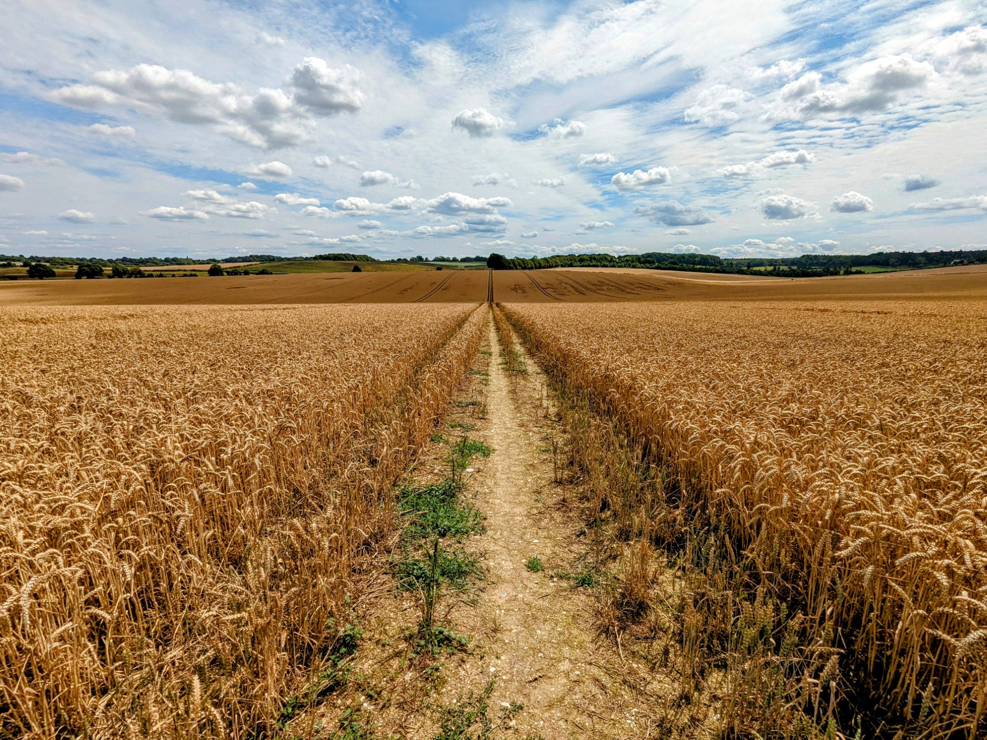
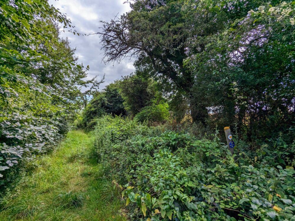
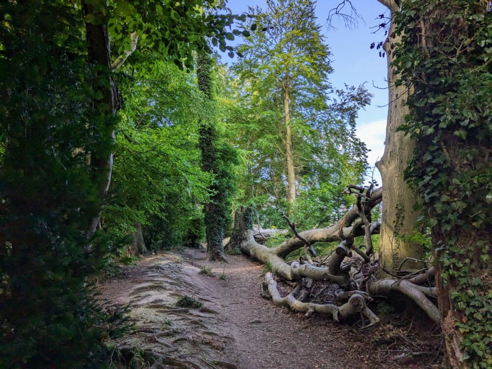
So all of that was great, and made the walking very easy and enjoyable. The only issue of any note was how overgrown some of the trails were, which was at least partially related to the time of year I was walking.
This is a pretty new route, and while it’s made from public footpaths, bridleways and pre-existing tracks, some of those paths clearly don’t see a lot of traffic. Walking towards the end of July after a hot, sunny June, growing conditions had clearly been very good.
Bashing through gorse and nettles for long periods isn’t really my idea of a good time, and I’m glad I had a hiking pole with me. It wasn’t needed for the hills, but it was definitely useful for pushing thorny branches and stinging leaves out of the way!
How Scenic Is It?
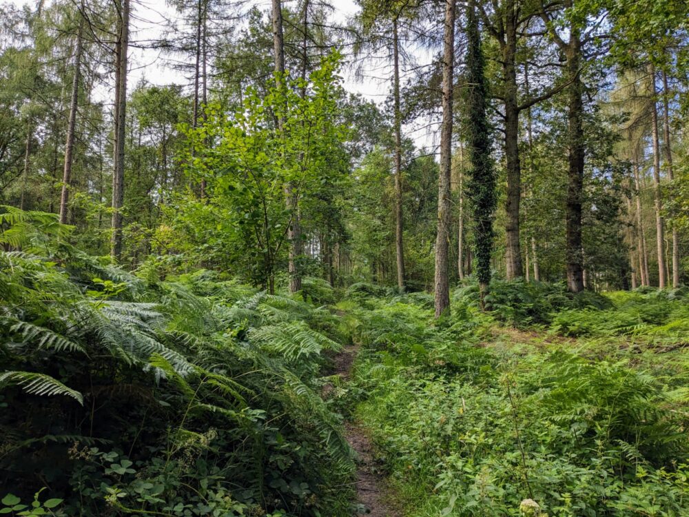
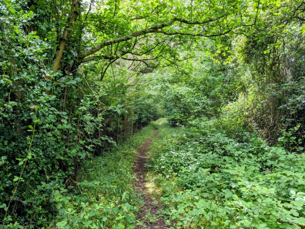
Beauty is in the eye of the beholder, and that’s as true with hiking trails as anything else. There were plenty of attractive parts of this walk, with lovely woodland and peaceful riverside trails, but you shouldn’t go into it expecting dramatic views or jaw-dropping scenery.
It’s often pretty, though, in the way that much of the countryside in the south of England can be, and if you’re anything like me you’ll still be regularly snapping photos each day: the route does a good job of picking out quiet bits of nature and avoiding built-up areas. Given that you’re never all that far from civilisation, however, untouched wilderness this is not.
In that regard, it’s much the same as the Camino routes that I’ve walked in Spain and Portugal. Medieval pilgrims weren’t choosing their path based on the views, they were finding the easiest routes between the relative safety of the towns and villages along the way.
You may not get stunning vistas around every corner, but you will get a comfortable bed, a hot shower, and a cold pint each night. It’s up to you which is more important!
Speaking of towns and villages, many of them are lovely in their own right. Alresford and Winchester are particularly great (you could easily spend an entire day just exploring Winchester’s history), and wandering around the ruined walls of the Roman town of Silchester was one of the highlights of the walk.
Where Does It Start and Finish?
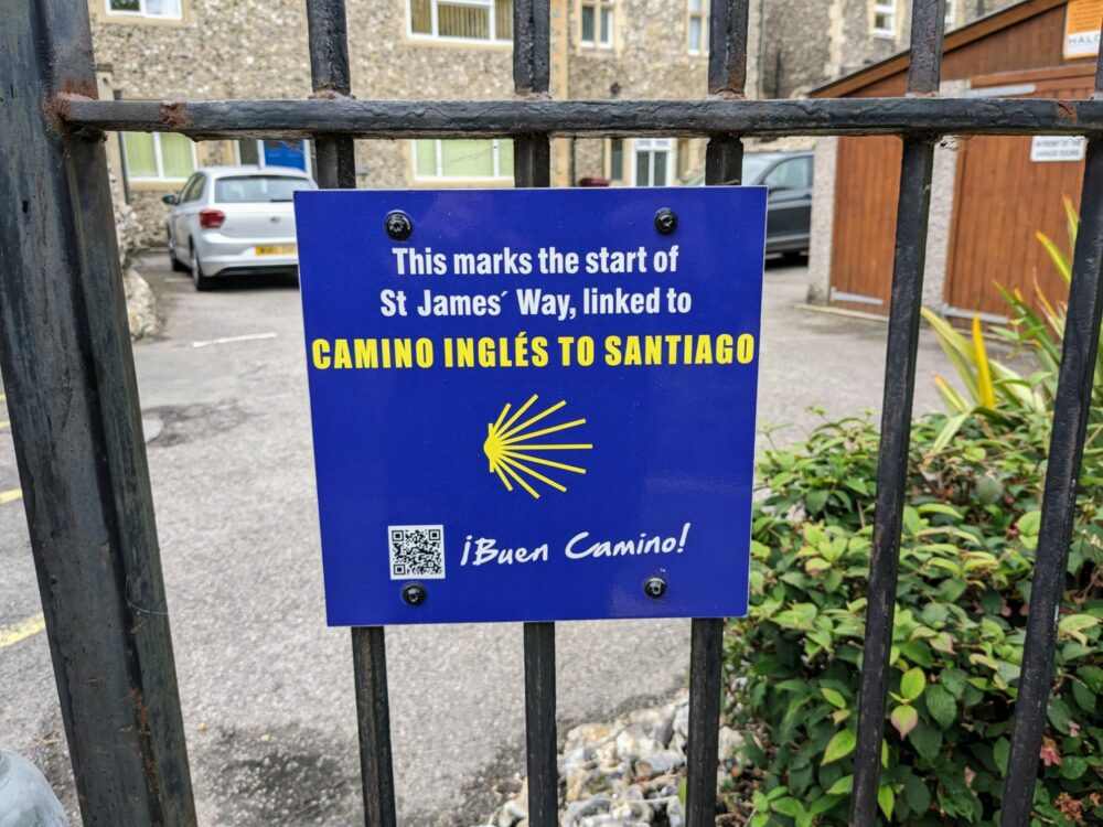
The route officially begins at St James’ Church in central Reading, alongside the ruins of Reading Abbey that was the English home of the cult of St James back in medieval times. A sign in the distinctive blue and yellow colours of the Camino marks the start point, attached to the railings of a fairly uninspiring carpark.
The end point in Southampton is at God’s House Tower, made up of some of the oldest buildings in the city. It’s almost on the water, with the docks just over the road: you’ll walk through a good chunk of Southampton to get there, both outer suburbs and the central city. There’s no official sign, at least not that I saw, but you won’t miss it.
How Long Is It?
At time of writing, the St James’ Way officially runs for 68.5 miles, or 110km, but I suspect that’ll go up and down a bit over time. Like any long-distance path, but especially one as new as this, route changes are inevitable.
People give or take away permission to walk on private land, better paths are found that avoid less desirable sections of trail, even changes to things like bus timetables and accommodation options can affect the route over time, and that’s before any detours due to weather and erosion.
Even with the route as it currently stands, the exact distance that you’ll walk is unlikely to be quite the same as anybody else’s. Staying off-route, especially in larger places like Reading, Basingstoke, or Winchester, will easily add a few extra miles. Likewise with exploring any of those centres once you’re done for the day, or hunting down specific restaurants or pubs rather than just whatever’s closest.
My Fitbit told me that I walked a total of 111km (69 miles) on the trail, and another 8km (5 miles) off it. I don’t usually put a lot of faith in those distances since my watch doesn’t use GPS, but it’s reasonably accurate when there aren’t any hills involved… which pretty much describes this walk!
How Popular Is It?
In recent years, some of the Camino routes on the Iberian peninsula have become a victim of their own success. The Camino Frances in particular was already getting very busy at peak times before the pandemic: throw in huge pent-up demand afterwards, and parts of it now feel more like the queue for the Central line at rush hour than a contemplative walk in nature.
Lets just say that the St James’ Way does not have this problem.
During my five days on the trail, I met exactly three other people who were walking it: a couple of older friends who were walking the entire route, and one other person who was doing it as day walks while house-sitting for a couple of weeks in Reading.
Things got a little busier on the sections of trail that ran close to towns and villages, with people walking their dogs or strolling along the towpath, but even then I’d often see nobody at all for twenty minutes at a time. Further away from civilisation, it sometimes felt like I was the only person left on the planet.
How Well Is It Signposted?
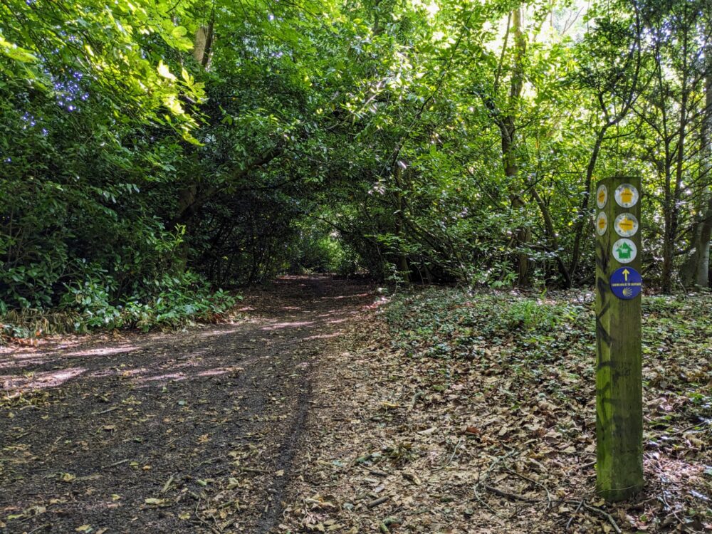
As I mentioned above, the waymarking on the St James’ Way has received a big boost in recent years, with Confraternity of St James volunteers nailing up hundreds of distinctive blue and yellow signs along the entire route. If you’ve ever walked a Camino in Spain, that scallop shell and yellow arrow will look very familiar.
Thanks to that effort, I’d now rate the overall waymarking as pretty good. Most (although not all) of the places where you’d expect to see a sign, there was one: trail junctions, gates and stiles, turnoffs, and the like.
There were many places where a hand-painted yellow arrow also showed the way if the track direction was unclear, and I was very glad of them! I’m not sure if those arrows were painted by CSJ volunteers or somebody else who just recognised the need for a bit of extra direction, but they certainly helped.
With all of that said, however, I still took wrong turns noticeably more often on this Camino route than others I’ve walked. None of them were a major issue, but they did make for a bit of backtracking at times, or trying to figure out how to join up with the proper route again after taking a different path.
Other than my dodgy navigation skills, the main issue was that none of my guides agreed with each other. I was using the latest version of the CSJ guidebook, paired with a route recorded on AllTrails, then trying to match up one or both with the waymarks. Sometimes they’d align perfectly, but often they wouldn’t, and I’d be left guessing which one to believe.
In the end, I settled on a simple approach. I’d follow the waymarking first and foremost, the guidebook when there weren’t any signs, and the AllTrails route as a last resort if it still wasn’t obvious where I was meant to be going.
Most of the time this worked out ok, but it definitely took a bit more effort than I was expecting. I’m sure things will improve significantly over time, however, especially as new versions of the guidebook come out.
I see that the CSJ is now offering its own GPX file for the route, which you can email them to get hold of. It’s a matter of a few seconds to load that route it into AllTrails, and if nothing else, it’ll match the guidebook more closely than the one I used! With any luck, you won’t find yourself wandering down random forest paths and through hedges quite as often as I did.
I talk more about the guidebook and app below.
How Long Does It Take to Walk?
The St James’ Way is relatively short by the standards of most multi-day walks, and the flat terrain means you can do more distance per day than usual if you want to. I walked the 70-odd miles pretty easily over five days, which included two shorter 10-12 mile days, and three moderate 15-mile ones.
If you’re used to walking much longer distances and this all sounds too easy, you could likely shave a day off without much difficulty. The only minor challenge would be finding accommodation that matched up with your desired distances, but even that wouldn’t be super-difficult.
Likewise, if you’d prefer to take things slowly and spread the walk out over six or seven days, you could: those two older walkers I mentioned were doing just that. They’d booked their accommodation a few months in advance, and one place needed a taxi to get to and from, but it all sounded easy enough.
Getting To and From the St James’ Way
Compared to many long-distance walks in the UK, travel logistics on the St James’ Way are very straightforward. Because the route starts and ends in the middle of good-sized cities and runs through several villages and towns along the way, it’s easy to find public transport that will get you where you need to go.
Getting to the start point really isn’t difficult. Reading is a major stop on the UK rail network, with regular trains from London Waterloo, Oxford, Birmingham, Bristol, and elsewhere.
Direct coaches also cover the above routes, along with many others. From Reading train station, it’s only a five minute walk to St James Church.
Returning home after you’re done is also easy. Southampton has its own airport with flights to a number of other cities in the UK, along with a few countries in Western Europe.
Direct trains regularly run from Southampton station back to Reading, as well as London, Cardiff, Brighton, and elsewhere, and coaches can take you further afield. The train station is about a 20 minute walk from God’s House Tower.
If you can’t secure accommodation within walking distance of the trail for a given night, public transport can often help there as well. On my first night, for example, I couldn’t find anywhere to stay close to the route, so I just took a bus from Mortimer back to Reading and returned the same way in the morning. The bus stops I needed were right on the route, and ran regularly.
Hell, if you wanted to, you could base yourself in Reading or Basingstoke for the entirety of the walk, and just use public transport to and from the trail each day. I met someone doing exactly that.
Can You Do It as Day Walks?
Because it’s so well served by public transport, there’s plenty of opportunity to treat sections of the St James’ Way as day walks. I’ve listed a couple of worthwhile options below, but you could easily create your own along most parts of the route.
- Mortimer to Worting (12.5 miles). Takes in Silchester Roman City, a couple of interesting churches, a good pub for lunch in Pamber End, and plenty of attractive walking in the countryside. Catch the 2 or 2a bus from Reading to Mortimer to start the walk, and the 8, 11, or 76 bus from Worting Road into Basingstoke at the end. From there, buses and trains run regularly to Reading, London, and elsewhere.
- Winchester to Eastleigh (9.5 miles). Includes the cathedral and all the other attractions in Winchester, St Cross Church and Hospital, some absolutely lovely walking beside the Itchen River, and a pub stop for lunch at Shawford. Take a train or bus to Winchester (or leave your car there) to start, and a direct train from Eastleigh back to Winchester, Basingstoke, or London at the end.
Weather
Like most walks in the south of England, the weather is likely to be variable even in summer, but shouldn’t cause you much hardship beyond wet clothes and muddy boots. I barely even got that, with a mix of blue skies and sullen grey clouds over the course of my five days, but little rain.
When it did rain, it was almost always overnight, or at least after I’d got in for the day. While there wasn’t a lot of mud around, that did make for wet grass and undergrowth in the mornings. Given how overgrown some sections were, it’s worth wearing shoes with some degree of waterproofing if you don’t love wet feet.
Temperatures in July were much milder than what they’d been a few weeks earlier, typically around 18 degrees Celsius. That’s great walking weather as far as I’m concerned, since I don’t have to carry several litres of water to stay hydrated or, alternatively, wear five layers of clothing to stay warm!
If you’re walking in the colder months, obviously your experience will differ. This is very much not alpine hiking or wading through endless bogs, but still, pack appropriately for the conditions and you’ll have a safe, enjoyable walk.
St James’ Way Accommodation
While this isn’t the Camino Frances and you’re not going to see an albergue (pilgrim hostel) beside the trail every couple of miles, there’s more accommodation on or near the route than what you’ll find on many other long-distance walks in the UK.
Spending hours poring over Google Maps figuring out where to stay, and then having to enquire about each place in order and wait for an answer, is one of my least-favourite parts of most walks like this.
By comparison, it was all pretty straightforward on the St James’ Way, even though I only decided I was doing it a month beforehand. All of the places I chose were listed on major booking sites, most with automatic confirmation, which made the process a lot quicker.
Since you’re so close to major towns and cities, most kinds of accommodation are available. From dorm beds in hostels through to high-end hotels, cozy BnBs to rooms above the local pub, you’ll likely stay in a range of different places.
There are no official campsites near the route, however, and not really many places where you’d want to try wild camping either, even if it was legal (it’s not). While you’ll find the odd farmer’s field or patch of woodland where you might be able to subtly put up a tent at the end of the day, most of the route is just too close to civilisation for it to be comfortable.
To fit in with the distances I wanted to cover, then, I ended up staying in a hotel in Reading, private rooms in people’s homes in Kempshott and Winchester, and above a pub in Alresford. Prices averaged out at a bit over £70/night for my dates in late July, booking a month out.
Because I was staying in London beforehand, I was able to take a train directly to Reading on the first morning, so didn’t have to pay for accommodation there the night before. Likewise, I booked a late afternoon train out of Southampton for the day I finished, avoiding the need to stay there overnight.
I go into more detail about each place in the day-by-day summary below. For the sake of having an accommodation list in one spot, though, here’s where I stayed during my time on the St James’ Way, with links for more information.
- Day 1: Ibis Reading Centre, Reading
- Day 2: Annex room in Kempshott, near Basingstoke
- Day 3: Swan Hotel, Alresford
- Day 4: Private room in an Airbnb, Winchester
Pilgrim Passport and Stamps
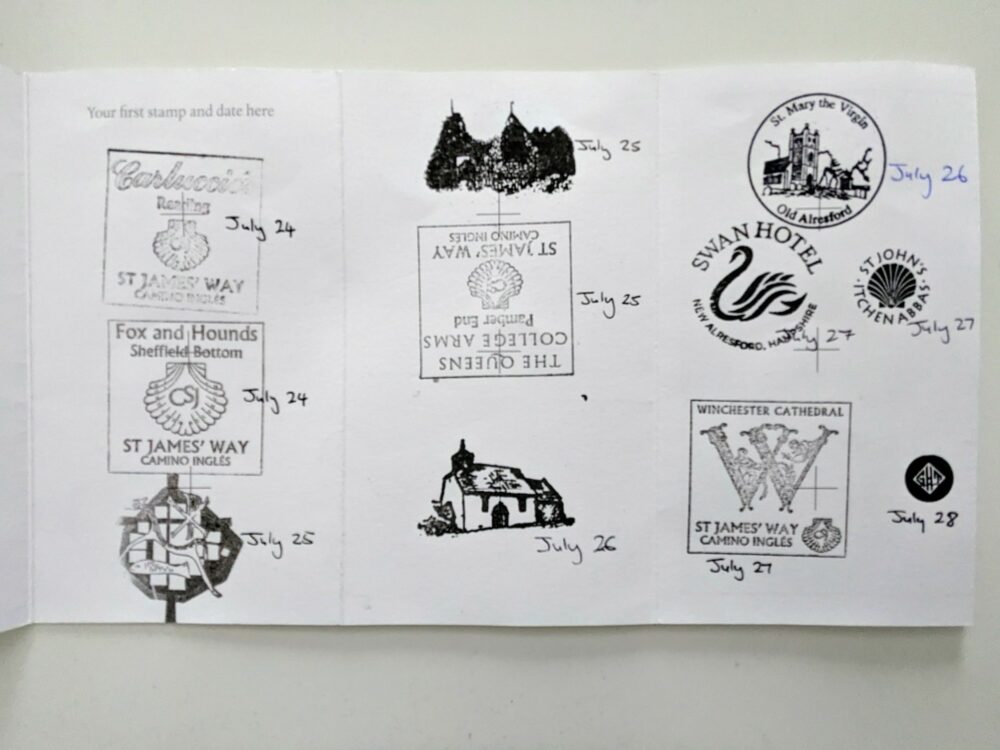
Most people walking any recognised Camino route will buy a pilgrim passport before setting out, and collect stamps in it as they make their way towards Santiago. At least on the routes I’ve walked, most of these stamps were from bars and albergues, with a few in churches, chapels, and cathedrals along the way.
As well as being a great souvenir at the end of the walk, these stamps also serve a practical purpose. Because the vast majority of albergues are intended to be used only by those walking a Camino, your collection of stamps provides a degree of proof that that’s what you’re doing. Your blisters and disheveled appearance likely provides the rest!
If you plan to get a compostela (certificate) at the pilgrim office in Santiago, you’ll also need to show your pilgrim passport. To be eligible for the certificate, you need to have walked at least 100km on a recognised route into Santiago, and again, it’s the stamps in your passport that prove this.
While the distance you walk on the St James’ Way does count towards that final 100km if you’re planning to continue on to Santiago, there’s no requirement to carry a pilgrim passport or collect stamps otherwise.
Even so, the folks behind the walk have put in quite a bit of effort to set the same system up along the St James’ Way, and it felt like the least I could do was use it. Virtually all of the pubs had stamps available, and at least in these early days of the walk’s existence, staff members were very excited to be able to use them!
Many of the churches, too, had stamps available near the entrance, often with a guest book to sign or a bit of historical information to learn as well. There usually wasn’t anybody around to do the physical stamping, but there’s no problem with doing it yourself.
The guidebook lists every place on or near the route that has a stamp available, so it’s easy to get one or two each day if you’d like to. I ordered my pilgrim passport from the Confraternity of St James when I bought the guidebook: it’s £6 for the passport and £12 for the guidebook. More on the latter below.
Apps and Guidebooks
Because it’s so new, the St James’ Way doesn’t have the same plethora of app and guidebook options that you’ll find for any of the popular Camino routes. There’s exactly one book, the slim version I mentioned above, and no apps that specifically include it.
Instead I just used AllTrails, my usual go-to hiking app. The entire trail is marked on it, and although it doesn’t exactly match the current route, most of it is the same. It definitely got me through a few tricky spots when neither the waymarking nor the guidebook were helping much!
Cell service is good along most (although not all) parts of the trail, which means you may be able to get away with the free version of the app. If you do want the certainty of being able to use it offline, though, you’ll need AllTrails+. It has a seven day free trial and is £3 a month after that, so it’s hardly going to break the bank.
The guidebook was the perfect size to fit in my shorts pocket, and had enough detail to be useful without becoming excessively thick. There’s a bit of history at the front, and plenty of sidebar sections with information about everything from Roman cities to churches and modern town services.
The rest of it was walking directions and distances, most of which were accurate and relatively easy to follow. I still went wrong a few times, sometimes in places where the route had clearly changed, elsewhere where the directions in the book were a little unclear, but it never took more than a few minutes to realise and get back on track.
Food and Drink
One of the big advantages of this route going through towns and cities of a reasonable size is that you have a lot more choice about what you eat than usual. The night that I spent in Reading, for instance, I had a surprisingly good bun bo hue at a Vietnamese restaurant. In Winchester, I went for the panang curry at a highly-rated Thai place, and was very glad that I did.
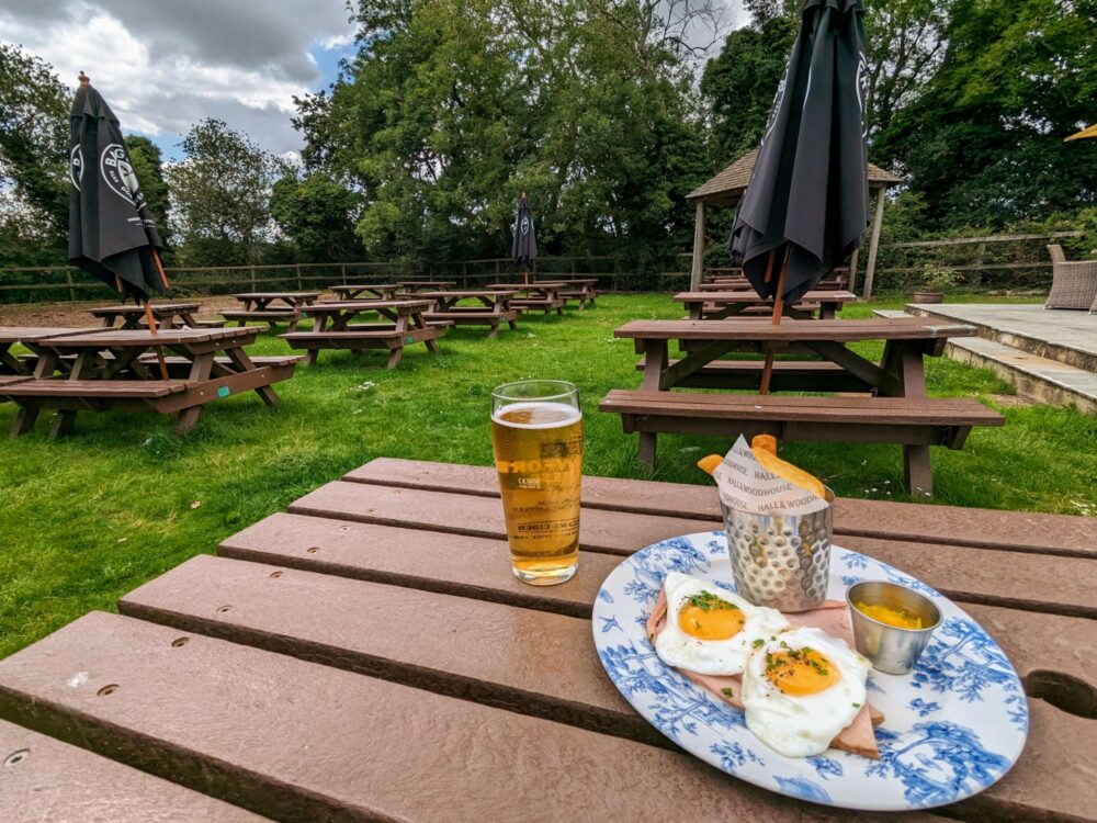
Even in smaller places, though, the food was generally very good. The ham, eggs, and chips in the photo above was the perfect lunch refuel at the Queens College Arms, a great pub in Pamber End with a big beer garden and super-friendly staff. Likewise with my dinner at the Swan Inn, some of the better fish and chips I’ve had in a country that’s renowned for it.
I started out with half a dozen protein bars in my bag and got through them all along the way, but in general it wasn’t hard to find enough to eat. There was the odd time where I walked faster than expected and the places I’d planned to stop for lunch weren’t yet open, particularly on the last day as I headed towards Southampton, but I was never in danger of starving.
Like most of the logistical stuff on this walk, eating well simply wasn’t a problem.
Costs
Multi-day walks in the UK are many things, but unless you’re camping and self-catering the entire way, cheap is rarely one of them. That’s particularly true during summer months in the southeast, especially if the only time you have available is the first week of the school holidays. Whoops.
Camping isn’t an option on this route, but because the St James’ Way often passes by or through large population centres that aren’t holiday destinations (Reading and Basingstoke, I’m looking at you), there was still plenty of accommodation available that didn’t require me to mortgage a kidney to stay there.
As I mentioned above, with a bit of research and flexibility, I was able to keep accommodation prices down to a bit over £70/night for a solo traveler. Given I’ve often spent around £50/night when sharing a room on other long-distance hikes in the UK, that didn’t seem too bad.
Two of the four places I stayed had breakfast included in the room rate, which helped keep food costs down as well. Elsewhere, I usually just grabbed a sandwich and a coffee from wherever was open before I set out for the day.
Lunch menus at pubs are often quite good value, and that’s what I’d end up having where I could. It’d usually be around £16–20 for a meal and a pint of something cold. Dinner locations varied a bit more, mixing things up between restaurants wherever there was a good one and pubs where there wasn’t.
Prices were fairly similar in either case, somewhere between £20–28 for a meal and a drink. One night I was staying somewhere that didn’t have anywhere appealing within walking distance, so I just grabbed a few bits and pieces from the local Tesco. Gourmet? No. Filling? Yes.
There weren’t many other costs to deal with. The bus between Mortimer and Reading costs the princely sum of £3 each way. My ticket from London to Reading cost just under £14, with the train back from Southampton a bargain at £7.90, admittedly booking well in advance.
Throw in the occasional extra coffee or snack, and that was pretty much it for costs. Relatively cheap by the standards of long-distance walks in the UK, it’s undoubtedly helped by being comparatively short as well.
The Walk Itself
All distances mentioned below are approximate since they were recorded on my Fitbit which doesn’t use GPS, but are reasonably close to what’s listed in the guidebook. They include the distance between the trail and my accommodation, but not any wandering around town for meals or sightseeing.
If you’re taking trains to and from the route, you can add an extra half-mile from Reading station to the start point, and an extra mile from the end point to Southampton Central station.
- Day 1: Reading Abbey to Mortimer Common, 12 miles/19km
- Day 2: Mortimer Common to Kempshott, 15.6 miles/25.1km
- Day 3: Kempshott to New Alresford, 15.8 miles/25.5km
- Day 4: New Alresford to Winchester, 9.8 miles/15.7km
- Day 5: Winchester to Gods House Tower, Southampton, 15.8 miles/25.4km
Day 1: Reading to Mortimer Common
The day was grey and gloomy when I woke up, and any hope of immediate improvement was quickly dashed when I looked at the weather forecast. Heavy rain for most of the morning. Fantastic.
Still, after a week-long drenching in Ireland earlier in the month, I at least had faith in my waterproof gear. Don’t get me wrong, I wasn’t excited at the prospect of another soaking, but it wasn’t like it’d come as some kind of surprise.
The first sprinkles started right on cue as I got to the station, with the downpour in full force by the time the train pulled away. The rain lasted the entire journey, but due to what could only be some kind of divine intervention (this is a pilgrimage route after all), largely stopped just as I arrived in Reading.
Like I mentioned, I hadn’t been able to find accommodation anywhere sensible along the route for the first day, so had just booked a room in Reading and planned to take a bus back at the end of the day.
It was a bit of a hassle, but it did mean I could leave my main backpack at the hotel before setting out, and walk footloose and fancy free with just my tiny foldup daypack holding a jacket, snacks, and bottle of water. Every cloud has a silver lining and all that. There were still plenty of clouds to choose from.
After stopping at Carluccio’s for a coffee and the first stamp in my pilgrim passport, I tracked down the sign at St James Church that marked the start point. There may be less inspiring places to start a long-distance walk, but beside a carpark on a damp, grey Monday morning in Reading, I was struggling to think of them.
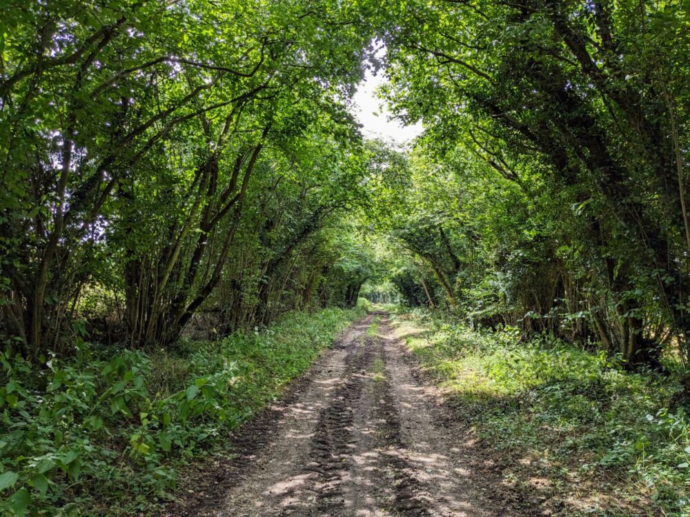
After a quick look around the ruins of the abbey, I followed the waymarks along the River Kennet and out of town. It didn’t take long for high street stores and road noise to be replaced by tree-lined paths and birdsong, and I was able to pack away my jacket for the rest of the day soon after. Things were definitely looking up.
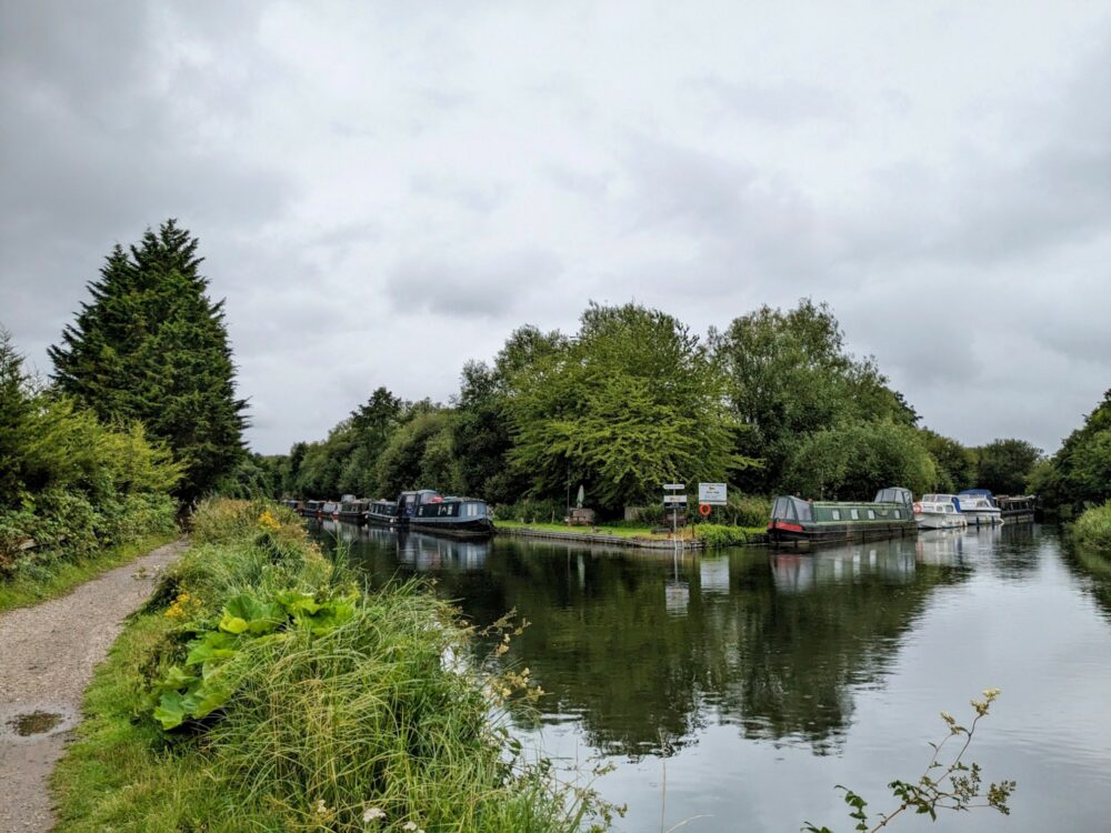
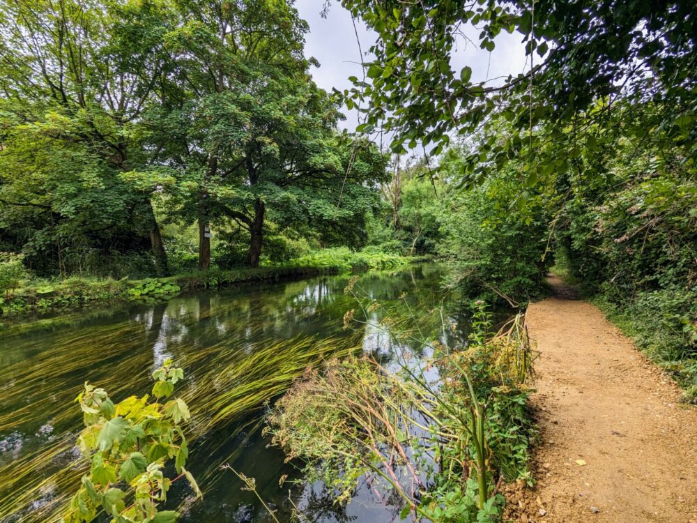
The entire first half of the day’s walk was beside the river and canal, on a mixture of narrow dirt paths and a wider, well-formed towpath all the way to Sheffield Bottom six miles away. Either way it was peaceful, dead flat as you’d expect, and very pleasant, easy walking. There’d be a lot of that over the next five days.
Lunch was at the Fox and Hounds, one of a handful of places along the way that gives a discount to pilgrims. They’re all listed on a piece of paper that came with the guidebook: you’ll need to ask the staff about it, but sure enough, I saved a few pounds on my beef sandwich. Can’t complain about that!
Rain threatened again as I left the pub, but never really returned: I was pretty glad about that, since there wasn’t a lot of shelter on the country roads and through the fields. The route was particularly pretty through woodland for a while, before emerging at St Mary’s church at Sulhamstead.
This was the first place where the guidebook and waymarks had a difference of opinion with my AllTrails map, to such an extent that the routes didn’t rejoin until the end of the day. I just followed the signs and arrows instead, mostly through pretty woodland, for three miles until my end point at Mortimer Common.
It looked like a nice little village, but I didn’t get much of a chance to find out: the bus stop I needed was only a few yards off the route, and a bus showed up just as I got to it. Forty minutes later I was deposited opposite the hotel I’d left several hours earlier, ready to retrieve my backpack and have a much-needed shower.
I was more than happy with my room at the Ibis: it was clean, modern, and quiet, within a few minutes walk of a whole bunch of restaurants. There was even an iron and ironing board, which came in particularly handy when the socks I’d washed in the sink hadn’t quite dried by morning.
Dinner was at Banh Mi QB, an unassuming Vietnamese restaurant in a little shopping mall that turned out a surprisingly good bun bo hue. I’ve been lucky enough to spend a lot of time in Vietnam over the years, and this was one of the better versions of this delicious soup that I’ve had outside the country.
And that was day one done!
Total distance: 12 miles (19km). Double room at Ibis Reading Centre: £69
Day 2: Mortimer Common to Kempshott
After a quick dash around central Reading to grab a coffee and sandwiches, I boarded the bus back to Mortimer and was on the trail again by 9:30am. The weather was dramatically better, blue skies and sun all day, and warm enough for a t-shirt without being hot enough to sweat through it in five minutes.
It didn’t take long to get out of town and into some delightful woods at Nine Acre Copse, before emerging out the other side straight into a vast field of corn that was taller than me. I followed the barely-visible path across as per the guidebook instructions, but can’t say I was especially confident about it!
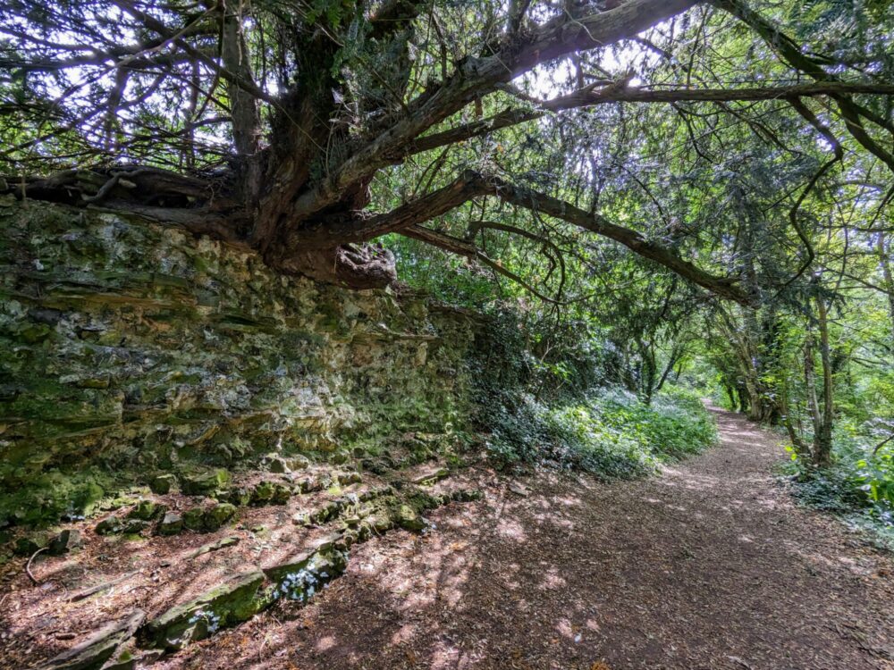
I arrived at Silchester Church soon after, and followed the waymarks around the site of the old Roman town of Calleva Atrebatum. A major centre until the Romans left Britain, ruins of the city walls and a nearby ampitheatre are mostly what’s left, at least above ground.
It’s absolutely worth the hour or so it takes to walk around the perimeter, especially the southern section where the walls are still several feet high. You can walk along part of the wall ruins, and so I did, with a great view over the expanse of ground that used to be home to nearly 10,000 people.
On a nice day, this really is one of the highlights of the walk: make time for it if you can!
The rest of the morning passed quickly, with more lovely walking through fields and forests, and only minor unplanned detours due to my inability to read the guidebook. Lunch was at the Queens College Arms, a great pub in Pamber End with friendly staff, good food, and a sunny beer garden that I was in no hurry whatsoever to leave.
I eventually worked up the motivation to drag myself onward, and was quickly glad I did: the walking was even better during the afternoon, even if my navigation skills weren’t. I’m still not quite sure which way I was meant to go at the signpost above, but following it through the hedge was definitely not it!
Other than the odd stinging nettle and wrong turn, though, this was probably my favourite afternoon of the entire route. I saw almost nobody other than golfers in the distance, and with the sun on my back and soft trails underfoot, I was very much in my happy place.

After stopping to admire the stunning field of (I think) phacelia near Worting, I mustered what was left of my energy for the final stretch into Kempshott. On the outskirts of Basingstoke, I’d managed to find some accommodation close to the trail, avoiding the need for a bus or taxi ride into town.
It was super-convenient, but because it’s very much in the suburbs, there wasn’t much in the way of restaurant options within walking distance. A quick Tesco stop soon fixed that, and I arrived at my accommodation with a cold bottle of cider, some sandwiches for dinner, and what felt like most of a farmer’s wheat field inside my shoes.
Speaking of accommodation, it was exactly what I needed: a cozy, self-contained room out the back of someone’s house, with a table and chairs outside for enjoying the evening sunshine, a strong shower, and supplies to make myself breakfast in the morning. Perfect.
Total distance: 15.6 miles (25.1km). Annex room: £65
Day 3: Kempshott to New Alresford
I woke up to another lovely morning, and after a quick breakfast at my accommodation, was walking again by 8:30 a.m. Everything started well, with a scenic trail through a long, narrow patch of woodland, before I lost the trail after crossing a busy, messy set of roads at the A30/A33 junction.
I think I just dropped down into the forest a little earlier than I was supposed to, and thanks to my map it didn’t matter in the end: I just made up my own route along other footpaths to join back up with the actual path about ten minutes later.
The section of trail that ran along one side of the M3, through a foot tunnel, and along the other side was suitably loud and unpleasant, but normal service resumed soon after as I took a quieter road down into Dummer and through farmland on the other side. It wasn’t the prettiest section of trail, but it was a hell of a lot more peaceful than what I’d just passed!
My plan of stopping for lunch at the pub at Preston Candover fell apart when I realised it wouldn’t open for another hour, so I made do instead with coffee and a little tub of ice cream at the village store just down the road. As it turned out, with rain forecast for the afternoon, a speedy meal probably wasn’t the worst idea in the world anyway.
After some unexciting road walking and (wait for it) taking a wrong turn in a field that introduced me to some very overgrown paths for a while, the route joined up with the Ox Drove Way and ran in a straight line through farms and forests for the better part of four miles. It was nice to not have to think about navigation for a while!
I ambled into Alresford mid-afternoon, which turned out to be a larger and fancier village than I’d expected. It’s apparently quite the destination every May, when it holds its annual watercress festival. Yes, watercress. The highlight is, of course, a watercress eating competition. If only I’d been in town a couple of months earlier.
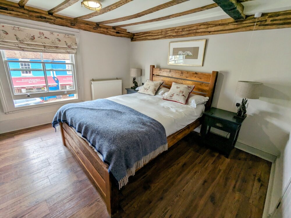
Instead, I had to make do with dinner at my accommodation, the Swan Hotel. There wasn’t any watercress on the menu, but there was a fish and chip special, a more than adequate substitute. I really liked my room: it had been fully renovated but still had plenty of character, and after two long days of walking in a row, the bathtub was extremely welcome.
I’d love to tell you what the rest of Alresford was like, but unfortunately that would have required me to leave aforementioned room. With that rain having arrived and now battering into the windows, and my feet extremely disinterested in putting shoes on again, it’ll just have to remain a mystery.
Total distance: 15.8 miles (25.5km), double room at Swan Hotel: £100
Day 4: New Alresford to Winchester
With only a short day ahead and a large cooked breakfast included in my room rate, lets just say that I didn’t exactly speed out the door first thing in the morning.
The rain had stopped sometime in the small hours, which meant that while there was plenty of mud and wet grass on offer for the first hour or so, nothing beyond my shoes was in much danger of getting wet. A bit of drizzle came and went throughout the day, but it never got any heavier.
Even though it was very much a short day, there was a higher proportion of road walking than usual, so it didn’t feel quite as easy as the distance suggested. Still, the paved stuff finished just before Itchen Stoke, a friendly farmer having provided a footpath that joins up directly with the Itchen Way.
Onwards I wandered into Itchen Abbas, where I stopped for a while to check out the St John the Baptist church (highlight: the gravestone of John Hughes, the last man to be hanged for horse stealing in England) before continuing on.
The rest of the day’s walk was nice enough without being particularly noteworthy, but there were a few pretty sections alongside the river, complete with herons and other birdlife to keep me company.
I was glad of the companionship: I hadn’t seen anyone else walking the St James’ Way for a couple of days. As it transpired, I wouldn’t see anybody else the rest of the way either!
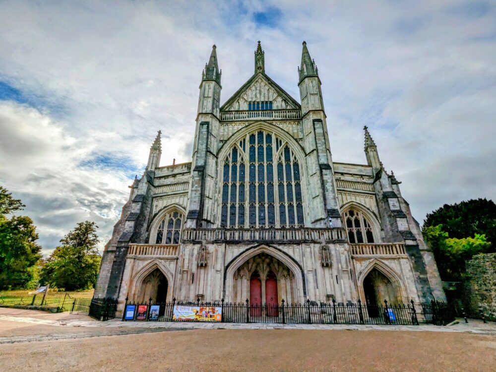
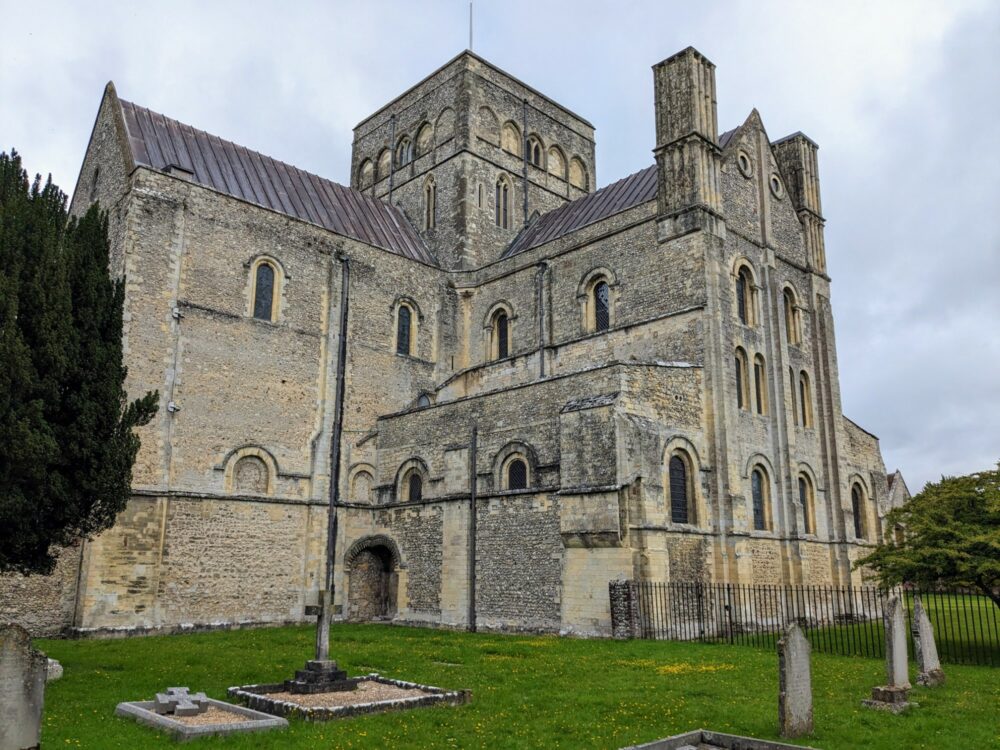
With all of the potential lunch stops along the way not yet open, it didn’t take long to get to the large church at St Bartholomew’s Hyde. Shortly afterwards, without even really expecting it, the trail deposited me in the middle of Winchester, a few steps from the famous cathedral.
I stopped in there to get a stamp, before whiling away the rest of the afternoon in pubs and coffee shops as I waited to check into my accommodation. It turned out to be a lovely little single attic room with its own bathroom, in a house near the train station around a ten minute walk from the city centre.
It was even closer to a well-rated Thai restaurant, Bangkok Bistro, that served up a very tasty panang curry to a hungry hiker in need. With a long final day in store and an early start on the agenda, that was me done for the day!
Sadly that place is no longer listed on Airbnb: good-value alternatives are in short supply in Winchester unless you’re a student, but I’d start with either here or here if you want to be fairly close to the action, or here if you don’t mind being a couple of miles from the centre.
Total distance: 9.8 miles (15.7km). Single room in Airbnb: £55
Day 5: Winchester to Southampton
And just like that, the final day dawned. Bright and early, as it happened: I was up before 7 a.m. and finishing my coffee in front of the cathedral an hour later. Winchester is a lovely city to explore, but fortunately I’d done that on my last visit: this time I just followed the waymarks straight out of town.
Around half an hour later I arrived outside the imposing structure of St Cross Church and Hospital, the oldest charitable institution in the country. To this day they still hand out a dole of bread and beer to pilgrims that stop in and ask for it, but sadly it was well before opening time as I passed. My alcoholic refreshment would need to wait a while longer.
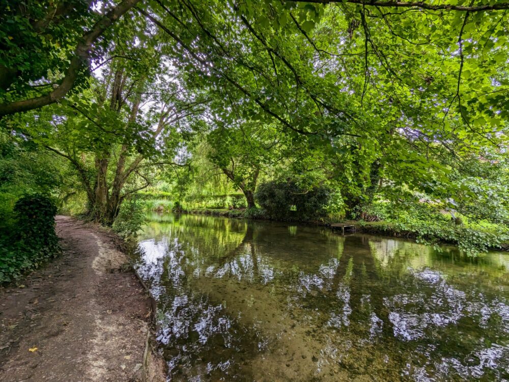
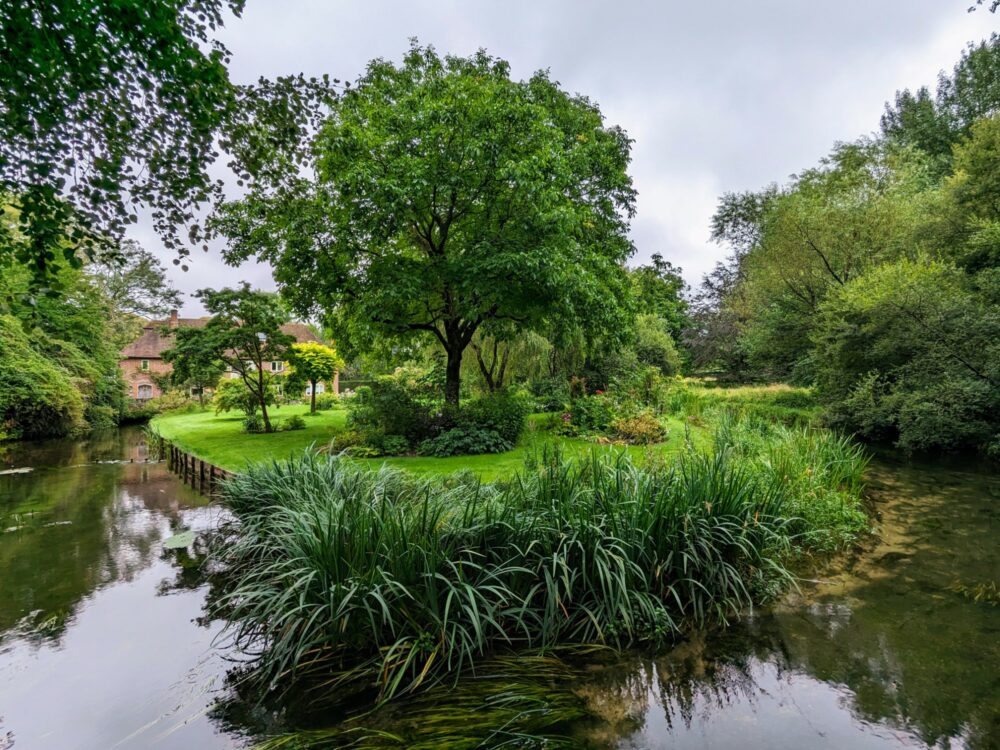
From there until almost the end of the walk nearly 15 miles away, the route largely follows the Itchen Way and, unsurprisingly, the River Itchen. I’m very glad that it does, as it’s a stunning waterway, calm and clear until it gets into Southampton, and one of the most important chalk streams in the world.
Even under overcast skies, the track between St Cross and Eastleigh (a distance of about seven miles) in particular was glorious. The river was quiet and peaceful, full of fish, ducks, and swans, and the trail ran through some lovely sections of countryside.
Yet again too early for lunch anywhere close to the trail in Eastleigh, I finished off my protein bars, zipped up my jacket against a sudden downpour, and strode onward. Straight into what was almost certainly the world’s largest collection of gorse and stinging nettles.
In less time than it takes to say “I really should have put on a pair of trousers this morning”, my previous good mood had darkened almost as much as the skies overhead. I don’t know why that particular section of trail was as overgrown as it was, but my tingling, bleeding legs could really have done without it.
Still, the undergrowth eventually relented after a mile or two, and it wasn’t long before I started seeing more signs of civilisation. The roar of the occasional plane coming into Southampton Airport was my first clue, and after a nice stroll through Riverside Park on the outskirts of town, things quickly got much more built up.
The path continued along the (much wider) river for quite some distance, before eventually veering off through some fairly unlovely suburbs to head towards the middle of town. It’s far from the nicest part of the route, but with only a couple of miles to go, I felt like I could forgive it.
Past the chain restaurants and high street shops I wandered, heading down towards the docks. I didn’t quite reach them, however: on the other side of the road from the ferry terminals lay God’s House Tower, the end point of my walk.
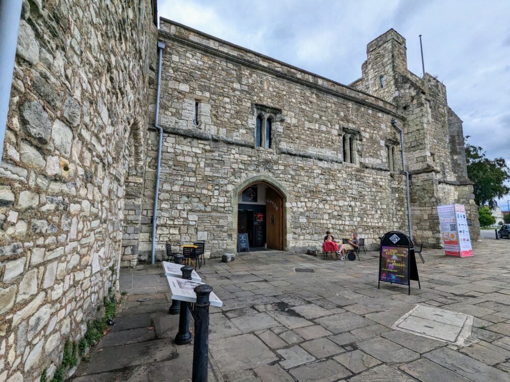
These buildings are some of the oldest in the city, having served as everything from a pilgrim resting place to fortifications against attack, town jail to now, a bustling arts and cultural centre.
Not that it was particularly busy as I walked in, sweaty and dishevelled, to claim my final stamp from the cheerful staff member. Note that it’s only open Thursday through Sunday: I was just lucky to finish on the right day!
The end was a little anti-climactic, but I find that with a lot of multi-day walks. What wasn’t anti-climactic, however, was the great pub a couple of doors down where I celebrated my achievement with a pint and a burger. The Platform Tavern was the kind of quirky, fun pub that I absolutely love, and if I hadn’t had a train to catch, I’d have likely stayed there for several hours more.
That train wasn’t going to wait for me, however, and so with one final grumble, I hoisted my pack onto my back for the last time and headed for the station. Another long-distance walk in the bag!
Total distance: 15.8 miles (25.4km) + 1 mile (1.6km) to the train station
Get regular travel, hiking, and tech updates from me
News, reviews, guides, and more, from here and around the web
Final Thoughts
So overall, how would I rate the St James’ Way?
In brief, I’d say it’s a great introduction to long-distance walking if you haven’t done a lot of it before. It’s long enough to present a bit of a challenge, but because it’s almost entirely flat and there’s more accommodation than you usually find on these sorts of walks in the UK, it’s still pretty straightforward.
The distances aren’t anything to be worried about if you walk it over five days like I did, but if you’d like to take a day or two longer, that’s easily achievable as well.
Because it runs so close to towns and cities, it’s not the most consistently scenic walk you’ll ever do, but many parts of it are still quite lovely. Food and accommodation options were excellent, with good public transport links at the start and end and many points in between.
It could (and almost certainly will) benefit from a few updates to the guidebook, extra signage here and there, and better track maintenance in a few sections, but none of that should put you off. The volunteers who created the St James’ Way have done a fantastic job so far, and I have no reason to believe that won’t continue into the future.
If you’re thinking about walking one of the Camino routes in Spain or Portugal and you’re looking to do a training run in the UK, this would be a great place to start. Even if you’re not intending to walk for weeks on the Iberian peninsula, though, there’s a lot to like about walking the St James’ Way. For most people, it will be well worth the comparatively small amount of effort required to do it.
It certainly was for me.
Did you find this guide to the St James’ Way useful? Did I leave anything out that you’d like to know more about? Let me know in the comments!
All images via author


Thank you for this fabulous summary of the St James’ Way. The CSJ are doing their best to improve the signage and keep the paths clear, and the more pilgrims who walk it, the better the route will become!
It really has the essence of a classic Camino, drawing pilgrims towards the ‘Camino Inglés’ in Northern Spain and ultimately Santiago Compostela, and a great ‘taster’ for those who may wish to sample a Camino before extending their experience to one of the wonderful Spanish Caminos.
Well-written, clear descriptions, thanks Dave. I love your photos. With greater interest hopefully the signage and track clearing will continue to happen.
Excellent content. My interest is piqued but I wonder if you have found a way to get from Southampton to Ferrol in Spain to continue on the Camino Ingles?
I haven’t, sadly — there are no ferries that go to A Coruna or Ferrol, and while you can fly there, you’d probably need to backtrack to a London airport to do it. I guess you could take the walking/ferry route I mentioned in the post from Southampton to Portsmouth to Santander and then take buses/trains to get to the start of the Camino Ingles as well. None of these routes are particularly direct, though.
If anyone else has a better idea of how to do it, feel free to leave a comment!
Thank you so much for this, I love your website and have used it for all my Camino’s. This is definitely on the list to do now, especially seeing how easily it can be done over weekends!
So happy you find the guides useful! I’m sure you’ll have a great time on this route – it’s definitely easy to do over two or three weekends.
Thank you so much for this ! Having completed Constance – Santiago but now with arthritis and cartilage problems , this sounds just perfect for me (I worked in Southampton as a youngest and later lived in Reading, so it brings together an awful lot!) you have taken so much trouble to include so much information .
I am using St. James’ Way ( 6 days) as a warm up for my third Camino. From Ferrol to Santiago in April. Finding accommodation using Booking. com and Airbnb dodging back and forth between the websites made the job a bit of a challenge ( needed two screens). Your notes are very informative and I’m looking forward to the nettle challenge.
I have previously walked Sarria and Porto to Santiago. my UK Pilgrimages include Rochester to Ramsgate and Northampton to Bedford.
Just read your blog having completed 3 days walking the SJW with my son and Ruby the dog, finishing at Upper Wield, so it was interesting to compare your experiences with ours, walking it in March rather than July. It was very muddy like over the top of your boots mud and at a couple of points as we walked beside the canal the water was pouring over the path, so we took off our boots and waded through. We loved the quirky old churches, rang the “pilgrim ” bell at Sulhamstead, admired the Roman walls at Silchester, and like you found the village shop at Preston Candover to be a lifesaver. Are you the Dave on the photo with Adrian pinned on the board outside the Old Church in Preston C?
Oh wow, that definitely sounds like a different experience! I suspect I was lucky (well, other than the nettles!) to be walking it after a long warm spell to dry out all that mud.
I’m not that Dave — there’s a lot of us around!
Great informative guide. Thank you. I’m intending to start my Camino in a couple of weeks from Pen Y Fan in the Brecon Beacons.
Hi Dave I am walking St James’ next week so found your guide a useful read thank you for all the effort you put into it. I’m hoping to do it in 5 days too! Just a bit concerned about booking my accommodation prior as I may not make it!
Yeah, I don’t love booking accommodation in advance on long-distance walks for exactly that reason! Sadly it’s been pretty unavoidable on most of the walks I’ve done, with the exception (in the past, at least) of the Camino. Sigh.
Starting walk this weekend Found your description very useful as I haven’t done this before. 😳😊
I found this information great as I was struggling to get any directions for this walk. I’m very grateful for this information.
Thanks Diane, glad I could help!
Thanks again Dave for so much useful information. I’d never heard of this walk until I’d found it on your blog. My husband and I have just completed it over 7 days and really enjoyed it all – easy but varied walking in some attractive countryside.
It might not have been published at the time of your walk, but there’s an excellent A-Z OS map book (in the same format as the National Trail A-Z Adventure Series). Stanford’s stock it.
Your tip about the yellow painted arrows was helpful but we also found some yellow painted bricks planted in a tricky bit of field about a mile south of Preston Candover.
So, thanks again Dave and good walking!
Thanks for your very informative guide, I’m thinking of doing the St James Way in the next year or so, and it was lovely to find so much info in one spot.
Thanks for this great write-up and advice! I’m planning on doing the St James Way later this year and this is the best info I’ve found online so far.