7 of the Best Day Walks Near Wanaka
Articles on this site contain affiliate links, meaning I may be compensated if you buy a product or service after clicking them. The full privacy & disclosure policy is here.If you’re into hiking, nature, and generally being awestruck by just how incredibly beautiful New Zealand can be, there are few better places to base yourself than Wanaka. This lakeside town in Central Otago feels like a playground for anybody who likes spending time in the outdoors, and I’m definitely one of those people.
For a relatively small town, the number of hiking trails in and around Wanaka is surprisingly large. You can get to the starting point of at least two good walks without needing a car at all, and dozens of others lie within easy driving distance.
It’s hard to go too far wrong with any of them, but if you’re short on time and are just looking for recommendations for accessible day walks in and around Wanaka, these are some of the best ones I’ve found so far. They’re arranged roughly by distance below.
I’ve walked all of these tracks in the last year or two, and they were open and unrestricted when I did. The times listed are taken from the official websites or trail signs, and are pretty accurate: I walk reasonably quickly, and found myself finishing at the lower end of the range each time.
In terms of route maps, I use AllTrails for pretty much all of my hiking these days, and the walks around Wanaka are no exception. I’ve linked to an appropriate map at the bottom of each description below: just create an account to bookmark the route(s) you think you might walk, then install the app on your phone beforehand.
Basic accounts are free, but I pay for AllTrails+ so I can download offline maps and get alerted when I take a wrong turn, among other benefits. It might be worth considering doing the same for at least some of these walks, as mobile phone service can be spotty or non-existent. There’s a 7-day free trial available.
Waterfall Creek Track
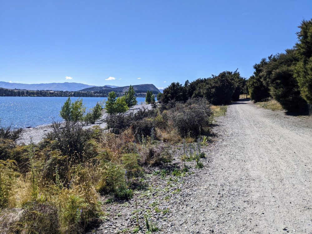
Part of the longer Glendhu Bay Track mentioned below, the walk to Waterfall Creek is a short, easy option appropriate for all ages. Starting beside that famous Wanaka tree, the flat, shaded path runs alongside the lake past the picnic area at Wanaka Station Park and Rippon winery before finishing at the carpark at Waterfall Creek.
There’s a small stony beach there for swimming and several large trees appropriate for enjoying a picnic under, although things can get quite busy in summer with people launching and retrieving their boats. Once you’re done, you can either get picked up or turn around and return the way you came for a total of around 5km/one hour of walking.
If there hasn’t been much rain lately, take a minute to help water the native plants towards the Waterfall Creek end of the trail. Plastic buckets lie alongside large barrels of water to help you do just that.
Keep an eye out for mountain bikers along the way: it’s a popular track with those on two wheels.
- Route: Waterfall Creek Track
- Length: 2.5km one way/5km return
- Duration: 30/60 minutes
- Difficulty: Easy
- Location: One end of the track is at the Waterfall Creek carpark at the end of Ruby Island Road, the other on the southwestern side of Roys Bay in central Wanaka
Mount Iron Track
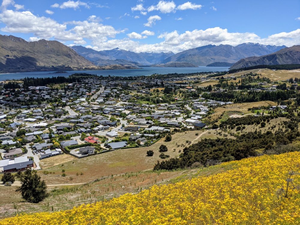
One of Wanaka’s most popular short walks, Mount Iron rises nearly 250m from the surrounding land just east of central Wanaka. From the carpark, the track zig-zags up the western side of the mountain through scrubby bushes and low trees until you reach a ridgeline that leads up to the summit.
While you’ll get some good views over Wanaka township and lake on the way up, the best vistas are from the top. From there, you can also see Lake Hawea, the Cardrona and upper Clutha valley, and many peaks of the Southern Alps. Information boards provide more context for what you’re looking at.
The track then continues down the eastern side of the mountain with views towards Albert Town, before looping around the base and heading back to the main carpark. There’s a secondary carpark that you’ll pass through on the way, which is useful if the main one is full when you arrive.
Despite the steady climb it’s still a relatively easy walk, although there’s little shelter from the weather either on the way up and down or at the summit. The track is mostly rocks and packed dirt, and since it’s somewhat uneven, it’s worth wearing proper shoes.
Note: you don’t have to drive to the start of the track if you’re staying in central Wanaka: it’s about a 20 minute walk from the main shopping/restaurant area.
- Route: Mount Iron Track
- Length: 4.5km loop
- Duration: 90 minutes
- Difficulty: Easy
- Location: Carpark on SH84, in Wanaka
Outlet Track
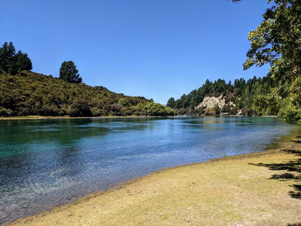
Lake Wanaka is the starting point of the Clutha River, the largest by volume in the country. The place where that journey to the sea begins is known as the Lake Outlet, and there’s a scenic walking trail that runs alongside the river to Albert Town called, unsurprisingly, the Outlet Track.
Starting from the large graveled area on Outlet Road that’s a popular spot to put boats into the water, look for the wooden sign and information board that marks the start of the trail. The flat, tree-lined path closely follows the meandering river, with several shaded spots beside the river to stop for a drink or picnic along the way, especially as you approach the end at the Gunn Road carpark.
If you’d like to add a little extra distance, carry on to the Albert Town bridge, or walk a short part of the Hikuwai Link Track up to Gunn Road and back again. Regardless of whether you tack on the extra sections or not, it’s an easy walk the entire way, and a great way of passing a couple of hours.
The trail is well-formed and generally quite wide, although it narrows in places and a short section had been washed away when I walked it, narrowing it even further. It’s popular with mountain bikers as well, so be prepared to step to the side of the track as needed.
For a (much) longer walk, you can start at Lakeside Road in Wanaka and follow the path along the lake to the beginning of the Outlet Track and beyond. Shown on the AllTrails route above, this turns it into a 12km one-way/24km return trip: you may want to try to arrange a lift in one direction.
- Route: Outlet Track
- Length: 6km return (plus optional 1.2km return Hikuwai Link)
- Duration: 90 minutes (plus optional 20 minutes)
- Difficulty: Easy
- Location: Albert Town. Carparks at either end, on Outlet Road or at the end of Gunn Road.
Diamond Lake/Rocky Mountain Walks
Variety is the spice of life, apparently, and you can’t complain about not having enough options when you head out to Diamond Lake. Whether you’re just after a short, easy nature walk or something longer and more strenuous with great views, you’ll find it there. Even better, the three loop trails are all connected, so there’s no need to decide in advance.
The track starts at the Diamond Lake carpark, heading up a short 4WD track to the start of a flat loop trail around the lake. It’s a pretty lake, but during the warmer months you won’t get to see all that much of it from the trail due to the trees and bushes along the edge.
For a better view once you’re finished the loop, head up the steep-ish steps to the northwest to a scenic viewpoint that overlooks the lake. It’ll add an extra 20 minutes or so to your walk.
From there, you’ve got the choice of returning back the way you came, or continuing on either the western or eastern sides of a longer loop track. The western route is rougher and a little steeper, and is probably easier to go up than come down.
The eastern route is generally more well-formed, but can get quite slippery and has steep drop-offs. I went up the western route and down the eastern one, but you can go either way or return the same way you went up.
If you don’t plan to go all the way to the top of Rocky Mountain but still want good views of Lake Wanaka, there’s a short side trail from the eastern route that leads to a viewpoint, complete with a seat for admiring the vista. Give yourself around two hours return to walk from the carpark to that viewpoint and back.
The final loop takes you up to the summit, again via either an eastern or western route. There’s no particular benefit to going one way over the other, but you may as well go up one way and down the other for the variation.
However you get up there, the view from the top makes the effort worthwhile. On a clear day you can see all the way to Mount Aspiring in one direction, and over Lake Wanaka in the other. There’s plenty of space at the top to take a breather, eat a snack, or even have a nap in the long grass for a few minutes like I may or may not have done.
My route took me up the western legs of the loop tracks, down the eastern legs, out to the Lake Wanaka viewpoint, and finally around Diamond Lake, and took almost exactly three hours including that snooze at the top.
- Route: Diamond Lake/Rocky Mountain
- Length: 2.5-7km return
- Duration: 45 minutes to three hours
- Difficulty: Easy to moderate
- Location: Carpark is 18km west of Wanaka, on the Wanaka-Mount Aspiring Road.
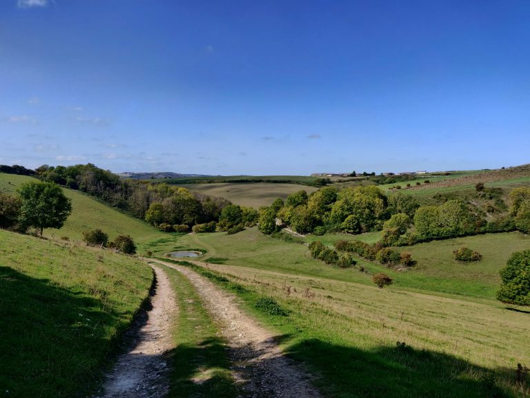
Glendhu Bay Track
Looking for a relatively easy walk that nonetheless provides plenty of great views and a solid amount of exercise? On a sunny day the Glendhu Bay Track is hard to beat.
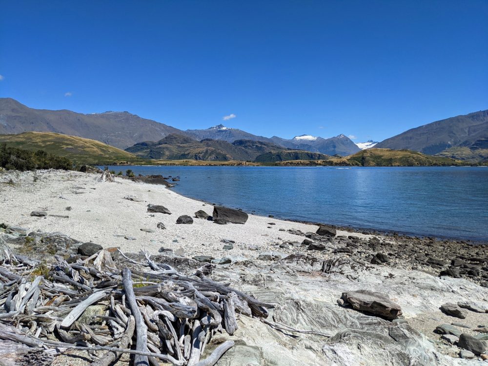
I started at the Glendhu Bay end, and the first half of the track to Damper Bay in particular was wonderful. The view across the lake to low foothills and snow-capped mountains was stunning, especially as the trail twisted and turned around the various small bays to provide different perspectives.
I was genuinely surprised by the number of little beaches and coves that I passed, most of which were accessible from the trail (perhaps with a little scrambling required) and many of which held nothing but driftwood for company.
The track is well-formed and mostly flat, although there are a few short climbs and descents that’ll help get the heart rate up. While there’s some shade and shelter for the last (or first) section of the trail at the Wanaka end, there’s little anywhere else, so take appropriate weather protection. There’s also nowhere to refill a water bottle once you’ve started.
If you can’t cajole someone into dropping you off at one end or picking you up at the other, water taxis operate between Wanaka and Glendhu Bay. They cost about $25 per person. You could also walk from either end to Damper Bay and back again, which would be roughly the same distance.
This is a shared mountain bike track, so keep an eye out for those on two wheels.
- Route: Glendu Bay Track
- Length: 15km one-way
- Duration: 3-4 hours
- Difficulty: Easy
- Location: One end of the track is beside the Glendhu Bay Campsite, the other on the southwestern side of Roys Bay in central Wanaka. For a slightly shorter walk, start/end at the Glendhu Bay Lookout carpark instead.
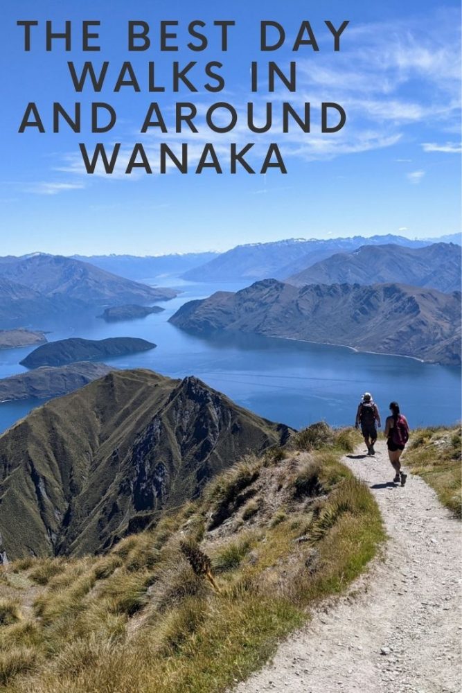
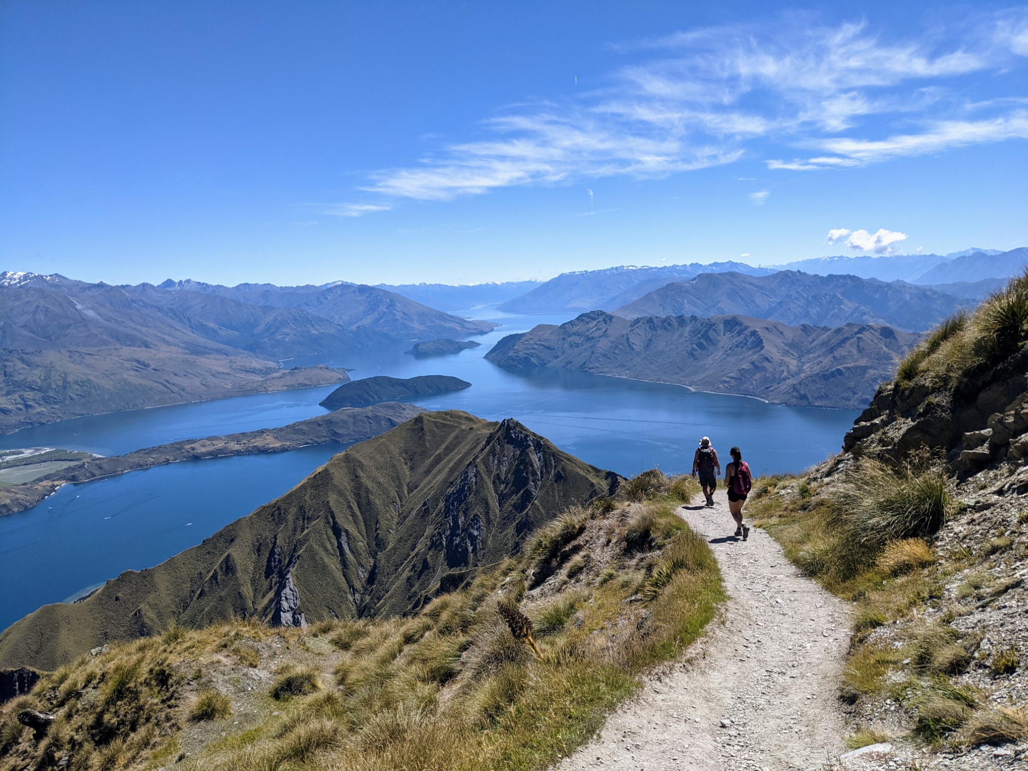
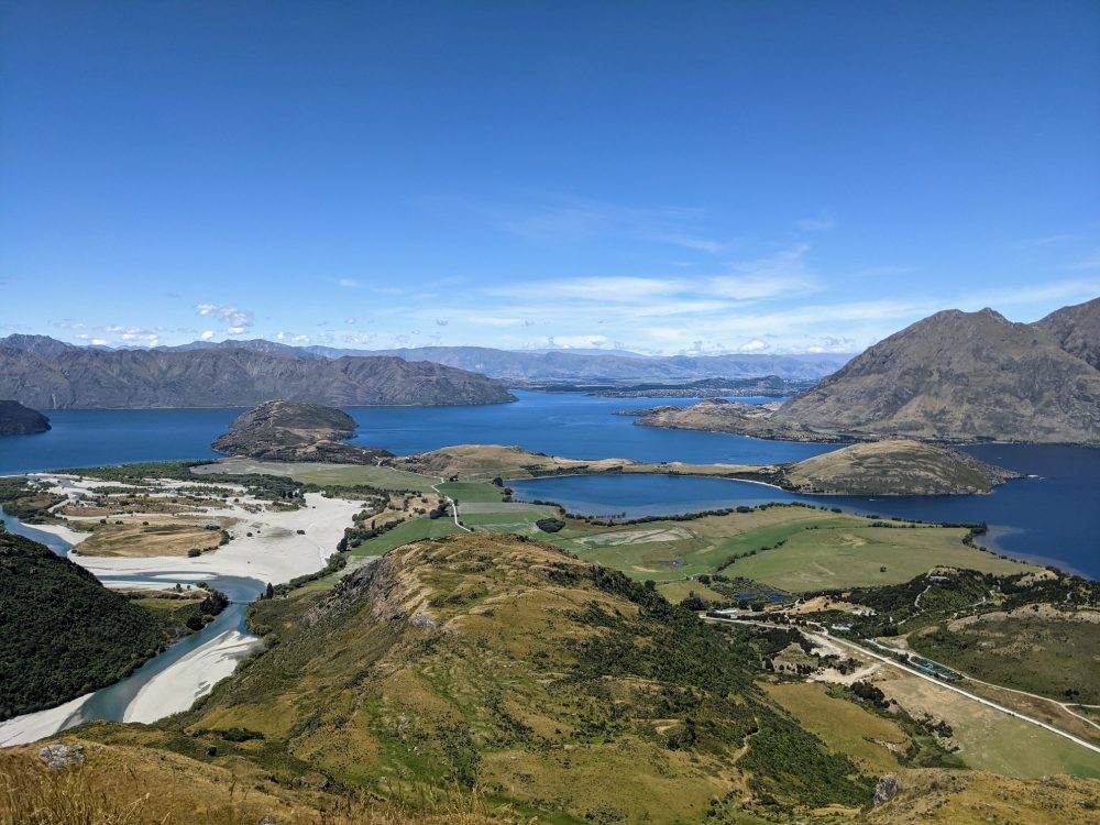
Roys Peak Track
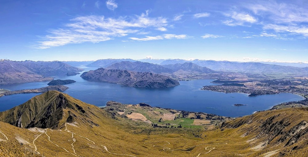
Made famous by a zillion Instagrammers, Roys Peak is undoubtedly one of the jewels in the crown of Wanaka’s hiking trails. Switchbacks climb steadily up the side of the mountain from the minute you leave the carpark, steeply for the first 45 minutes and then somewhat less so for the remaining couple of hours to the lookout that has stunning views over Lake Wanaka and the surrounding peaks.
That lookout is where most of the famous photos are taken from, but you can also continue for an extra half hour or so up to the summit. That’s where I took the above shot, and it’s different and spectacular enough to make it worth the extra effort. Again, switchbacks lead you to the top.
The track is relatively wide and well-formed, making it a steady rather than difficult climb and descent. It’s a lengthy ascent, though, and there’s virtually no shelter anywhere on the track, so expect to be exposed to whatever weather the day has in store.
I went on a cloudless 28 degree (C) day, and it was… sweaty. Two litres of water was the bare minimum, and I was almost out by the time I got back. I arrived at 8am, and soon wished I’d been there two hours earlier. Those who’d started in the late morning really looked to be struggling when I passed them on the way down.
Similarly, if there’s wind or rain around, you’ll want appropriate clothing for the conditions at the top, not just those at the bottom: there’s a 1200m+ difference between the two. There’s a toilet in the carpark, and another one at the lookout.
In non-pandemic times this is a very popular walk, to the point where the large carpark at the bottom is often full and there can be a long line of people at the lookout waiting to get their perfect photo. When I was last there at the start of 2021, however, there were only a few other people around.
- Route: Roys Peak Track
- Length: 16km return
- Duration: 5-6 hours
- Difficulty: Moderate
- Location: Carpark is 6km west of Wanaka, on the Wanaka-Mount Aspiring Road.
West Matukituki Track (to Aspiring Hut)
It’s a bit further away from Wanaka than the rest of these walks, but if you’re happy to drive for an hour and put up with a pretty bad road, the Matukituki Valley is a spectacular part of the world that’s home to a number of great walking tracks.
The Rob Roy Track is probably the most well-known in the area, but since it was closed when I last visited, I decided to go for something a little different.
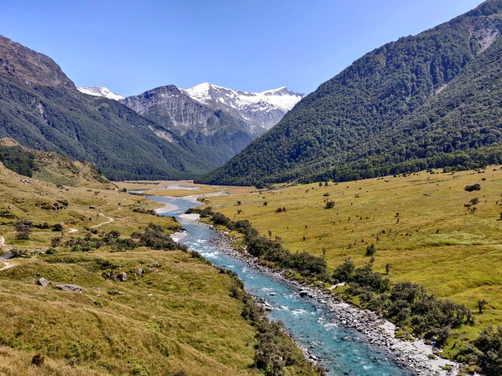
The West Matukitauki Track starts from the same place, the Raspberry Flat carpark, and initially runs along the same trail. Instead of crossing over the swing bridge, however, you carry on beside the river, across grassy flats and small bluffs with spectacular views towards the Rob Roy glacier and down the valley before ultimately ending up at Aspiring Hut.
It’s possible to spend the night here, but there’s no particular need unless you’re planning to continue on to the end of the West Matukituki track or join up with the Liverpool track further up the valley. Instead, enjoy a leisurely lunch or snack beside the hut (but watch out for sandflies) before turning around and heading back.
There are plenty of good photo opportunities along the trail, along with a couple of spots that are ideal for taking a quick (and definitely refreshing) dip in the river to cool off. There was also one small creek that needed to be waded through when I walked it, although it was only ankle-deep at the time.
It’s not a particularly difficult hike, being mostly flat and on well-formed trails, but there’s virtually no shelter the entire way. If you do it on a 30+ degree (C) day like I did, you’ll want to bathe in sunscreen and carry far more water than you think you’ll need!
There are flush toilets available (in summer) and a water supply at the car park, although you’ll probably want to bring your own since it’s advisable to boil what comes out of the tap. If you’re lucky, the local landowner will also be running a caravan selling ice-cream and cold drinks a few kilometres back down the road on your way out!
- Route: West Matukituki Track to Aspiring Hut
- Length: 18km return
- Duration: 5-6 hours
- Difficulty: Easy
- Location: The track starts at Raspberry Flat carpark, 54km west of Wanaka at the end of the Wanaka-Mount Aspiring Road. The last half is gravel, pretty rough in places and only passable in fine weather, so expect the drive from Wanaka to take around an hour.
Got any other favourite walks in and around Wanaka? Let me know about them in the comments!